Branchville, South Carolina
| Branchville, South Carolina | |
|---|---|
| Town | |
|
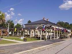
Depot during Raylrode Daze 2007 | |
 Location in Orangeburg County, South Carolina | |
| Coordinates: 33°15′7″N 80°49′4″W / 33.25194°N 80.81778°WCoordinates: 33°15′7″N 80°49′4″W / 33.25194°N 80.81778°W | |
| Country | United States |
| State | South Carolina |
| County | Orangeburg |
| Area | |
| • Total | 3.3 sq mi (8.5 km2) |
| • Land | 3.3 sq mi (8.5 km2) |
| • Water | 0.0 sq mi (0 km2) |
| Elevation | 115 ft (35 m) |
| Population (2000) | |
| • Total | 1,083 |
| • Density | 331/sq mi (127.9/km2) |
| Time zone | EST (UTC-5) |
| • Summer (DST) | EDT (UTC-4) |
| ZIP code | 29432 |
| Area code(s) | 803 |
| FIPS code | 45-08245[1] |
| GNIS feature ID | 1220931[2] |
| Website |
www |
Branchville is a town in Orangeburg County, South Carolina, United States. The population was 1,024 at the 2010 census.
History
The Southern Railway Passenger Depot was added to the National Register of Historic Places in 1973.[3]
Geography
Branchville is located at 33°15′7″N 80°49′4″W / 33.25194°N 80.81778°W (33.252055, -80.817778).[4]
According to the United States Census Bureau, the town has a total area of 3.3 square miles (8.5 km2), all of it land.
Demographics
| Historical population | |||
|---|---|---|---|
| Census | Pop. | %± | |
| 1870 | 366 | — | |
| 1880 | 517 | 41.3% | |
| 1890 | 732 | 41.6% | |
| 1900 | 1,101 | 50.4% | |
| 1910 | 1,471 | 33.6% | |
| 1920 | 1,814 | 23.3% | |
| 1930 | 1,689 | −6.9% | |
| 1940 | 1,351 | −20.0% | |
| 1950 | 1,353 | 0.1% | |
| 1960 | 1,182 | −12.6% | |
| 1970 | 1,011 | −14.5% | |
| 1980 | 1,769 | 75.0% | |
| 1990 | 1,107 | −37.4% | |
| 2000 | 1,083 | −2.2% | |
| 2010 | 1,024 | −5.4% | |
| Est. 2015 | 989 | [5] | −3.4% |
| U.S. Decennial Census | |||
As of the census[1] of 2000, there were 1,083 people, 446 households, and 276 families residing in the town. The population density was 331.2 people per square mile (127.9/km²). There were 508 housing units at an average density of 155.3 per square mile (60.0/km²). The racial makeup of the town was 54.48% White, 43.12% African American, 0.18% Native American, 0.09% Asian, 1.11% from other races, and 1.02% from two or more races. Hispanic or Latino of any race were 1.39% of the population.
There were 446 households out of which 27.8% had children under the age of 18 living with them, 41.7% were married couples living together, 16.6% had a female householder with no husband present, and 37.9% were non-families. 35.7% of all households were made up of individuals and 15.5% had someone living alone who was 65 years of age or older. The average household size was 2.39 and the average family size was 3.12.
In the town the population was spread out with 26.3% under the age of 18, 9.1% from 18 to 24, 24.0% from 25 to 44, 24.6% from 45 to 64, and 16.0% who were 65 years of age or older. The median age was 38 years. For every 100 females there were 84.2 males. For every 100 females age 18 and over, there were 72.7 males.
The median income for a household in the town was $22,429, and the median income for a family was $34,625. Males had a median income of $26,607 versus $20,917 for females. The per capita income for the town was $14,509. About 17.5% of families and 20.7% of the population were below the poverty line, including 27.8% of those under age 18 and 18.6% of those age 65 or over.
See also
References
- 1 2 "American FactFinder". United States Census Bureau. Archived from the original on 2013-09-11. Retrieved 2008-01-31.
- ↑ "US Board on Geographic Names". United States Geological Survey. 2007-10-25. Retrieved 2008-01-31.
- ↑ National Park Service (2010-07-09). "National Register Information System". National Register of Historic Places. National Park Service.
- ↑ "US Gazetteer files: 2010, 2000, and 1990". United States Census Bureau. 2011-02-12. Retrieved 2011-04-23.
- ↑ "Annual Estimates of the Resident Population for Incorporated Places: April 1, 2010 to July 1, 2015". Retrieved July 2, 2016.
External links
- Town Website
- History of Branchville
- Info on Branchville
- Raylrode Daze Festivul Homepage
- Webpage on Town of Branchville from Orangeburg County
Municipalities and communities of Orangeburg County, South Carolina, United States | ||
|---|---|---|
| City |  | |
| Towns | ||
| CDPs |
| |
| Unincorporated communities | ||