Braeburn Heights, New Jersey
| Braeburn Heights, New Jersey | |
|---|---|
| Unincorporated community | |
|
Homes along Groveland Avenue in the Braeburn Heights section of Ewing, New Jersey | |
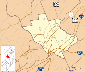 Braeburn Heights, New Jersey  Braeburn Heights, New Jersey  Braeburn Heights, New Jersey Location of Braeburn Heights in Mercer County Inset: Location of county within the state of New Jersey | |
| Coordinates: 40°15′24″N 74°46′06″W / 40.25667°N 74.76833°WCoordinates: 40°15′24″N 74°46′06″W / 40.25667°N 74.76833°W | |
| Country |
|
| State |
|
| County | Mercer |
| Township | Ewing |
| Elevation[1] | 108 ft (33 m) |
| GNIS feature ID | 874891[1] |
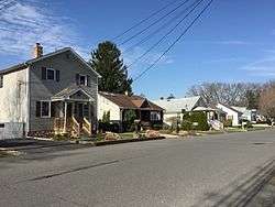
Braeburn Heights is a neighborhood located within Ewing Township in Mercer County, New Jersey, United States.[2] It is a residential neighborhood primarily consisting of detached, single family homes built from the 1940s through the 1970s.[3]
References
- 1 2 "Braeburn Heights". Geographic Names Information System. United States Geological Survey.
- ↑ Google (January 9, 2015). "Braeburn Heights, New Jersey" (Map). Google Maps. Google. Retrieved January 9, 2015.
- ↑ "Brae Burn Heights, Ewing Township, New Jersey". livingplaces.com. Retrieved 2015-01-18.
Brae Burn Heights (also known as Brae Burn Park) is a residential neighborhood of detached, single family homes built from the 1940s through the 1970s. Median lot size is less than 1/5th of an acre. The Brae Burn Heights neighborhood is generally bounded by Parkside Avenue, Pennington Road, Somerset Street and Buttonwood Drive.

This article is issued from Wikipedia - version of the 6/8/2016. The text is available under the Creative Commons Attribution/Share Alike but additional terms may apply for the media files.