Brașov County
| Brașov County Județul Brașov | ||
|---|---|---|
| County | ||
|
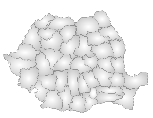
Administrative map | ||
| ||
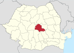 Location of Brașov County in Romania | ||
| Coordinates: 45°47′N 25°17′E / 45.79°N 25.28°ECoordinates: 45°47′N 25°17′E / 45.79°N 25.28°E | ||
| Country |
| |
| Development region1 | Centru | |
| Historic region | Transylvania | |
| Capital city (Reședință de județ) | Brașov | |
| Government | ||
| • Type | County Board | |
| • President of the County Board | Aristotel Căncescu (National Liberal Party) | |
| • Prefect2 | Adriana Donțu | |
| Area | ||
| • Total | 5,363 km2 (2,071 sq mi) | |
| Area rank | 25th in Romania | |
| Population (2011 census[1]) | ||
| • Total | 549,217 | |
| • Rank | 13th in Romania | |
| • Density | 100/km2 (270/sq mi) | |
| Time zone | EET (UTC+2) | |
| • Summer (DST) | EEST (UTC+3) | |
| Postal Code | 50wxyz3 | |
| Area code(s) | +40 x684 | |
| Car Plates | BV5 | |
| GDP | US$ 6.63 billion (2008) | |
| GDP/capita | US$ 11,262 (2008) | |
| Website |
County Board County Prefecture | |
|
1The developing regions of Romania have no administrative role. They were formed just to attract funds from the European Union 2 as of 2007, the Prefect is not a politician, but a public functionary. He (or she) is not allowed to be a member of a political party, and is banned to have any political activity in the first six months after the resignation (or exclusion) from the public functionary corps 3w, x, y, and z are digits that indicate the city, the street, part of the street, or even the building of the address 4x is a digit indicating the operator: 2 for the former national operator, Romtelecom, and 3 for the other ground telephone networks 5used on both the plates of the vehicles that operate only in the county limits (like utility vehicles, ATVs, etc.), and the ones used outside the county | ||
Brașov (Romanian pronunciation: [braˈʃov]) is a county (județ) of Romania, in Transylvania, with the capital city at Brașov. The county incorporates within its boundaries most of the Medieval "lands" (țări) Burzenland and Făgăraș.
Name
In Hungarian, it is known as Brassó megye, and in German as Kreis Kronstadt. During Austro-Hungarian administration, from 1876 to 1918, there was a county with similar name (see: Brassó County).
Demographics
In October 20, 2011, it had a population of 549,217 and the population density was 100/km².[1]
- Romanians – 87.4%
- Hungarians – 7.77%
- Romas – 3.5%
- Ethnic Germans – 0.65%
| Year | County population[1][2] |
|---|---|
| 1948 | 300,836 |
| 1956 | |
| 1966 | |
| 1977 | |
| 1992 | |
| 2002 | |
| 2011 |
Traditionally the Romanian population was concentrated in the West and South-West of the County, the Hungarians are in the East part of the county, and the Germans were in the North and around Brașov city.
Geography
The county has a total area of 5,363 km².
The South side comprises the Carpathian Mountains (Southern Carpathians and Eastern Carpathians) with Făgăraș Mountains, Bucegi Mountains, Piatra Mare Mountains, Piatra Craiului Mountains and the Postăvarul Massif. In the east side there is the Brașov Depression, and in the west side there is the Olt River valley. Between them there are the Perșani Mountains. The North and West side of the county is crossed by the Olt River.
Neighbours
- Covasna County in the East.
- Sibiu County in the West.
- Mureș County and Harghita County in the North.
- Argeș County, Dâmbovița County and Prahova County in the South.
Economy
Brașov is one of the most prosperous regions of Romania and has a tradition in industry. During World War II, IAR 80 and towards the end of the war Bf109, fighter aircraft were built in Brașov. During the communist period it was heavily industrialised, and its heritage were some very large industrial complexes. Some of them managed to survive and adapt to the capitalist type market economy, some of them didn't, leaving behind them a high rate of unemployment. Due to new investments, mainly foreign ones, the economy managed to partially recover.
The predominant industries in the county are:
- Mechanical and automotive industry.
- Chemical industry.
- Construction materials.
- Food industry.
Around Victoria there are big chemical complexes which pollute the region.
Tourism
Brașov contains some of the most attractive tourist destinations in Romania.
The main tourist attractions in the county are:
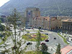
- The city of Brașov.
- Poiana Brașov mountain resort.
- Predeal mountain resort.
- Bran with its castle often referred to as Dracula's castle.
- The Făgăraș Mountains.
- The medieval fortresses of Făgăraș and Râșnov.
- The Fortified churches from the Saxon villages in the Burzenland area.
Politics
The Brașov County Council, elected at the 2016 local government elections, is made up of 35 counselors, with the following party composition:[3]
| Party | Seats | Current County Council | ||||||||||||||||
|---|---|---|---|---|---|---|---|---|---|---|---|---|---|---|---|---|---|---|
| National Liberal Party | 16 | |||||||||||||||||
| Social Democratic Party | 11 | |||||||||||||||||
| Democratic Alliance of Hungarians | 3 | |||||||||||||||||
| Ecologist Party | 3 | |||||||||||||||||
| Democratic Forum of Germans | 2 | |||||||||||||||||
Administrative divisions
Brașov County has 4 municipalities, 6 towns and 48 communes:
- Communes
- Apața
- Augustin
- Beclean
- Bod
- Bran
- Budila
- Bunești
- Cața
- Cincu
- Comăna
- Cristian
- Crizbav
- Drăguș
- Dumbrăvița
- Feldioara
- Fundata
- Hălchiu
- Hărman
- Hârseni
- Hoghiz
- Holbav
- Homorod
- Jibert
- Lisa
- Mândra
- Măieruș
- Moieciu
- Ormeniș
- Părău
- Poiana Mărului
- Prejmer
- Racoș
- Recea
- Șercaia
- Șinca
- Șinca Nouă
- Sâmbăta de Sus
- Sânpetru
- Șoarș
- Tărlungeni
- Teliu
- Ticușu
- Ucea
- Ungra
- Vama Buzăului
- Viștea
- Voila
- Vulcan
References
| Wikimedia Commons has media related to Brașov County. |
- 1 2 3 "Population at 20 October 2011" (in Romanian). INSSE. 5 July 2013. Retrieved 9 July 2013.
- ↑ National Institute of Statistics, "Populația la recensămintele din anii 1948, 1956, 1966, 1977, 1992, 2002" Archived September 22, 2006, at the Wayback Machine.
- ↑ "Mandate de CJ pe judete si competitori" (in Romanian). Biroul Electoral Central. 10 June 2016. Retrieved 16 June 2016.