Bordertown, South Australia
| Bordertown South Australia | |||||||||||||
|---|---|---|---|---|---|---|---|---|---|---|---|---|---|
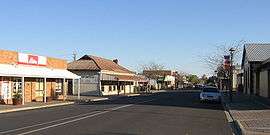 Main street in Bordertown | |||||||||||||
 Bordertown | |||||||||||||
| Coordinates | 36°18′0″S 140°46′0″E / 36.30000°S 140.76667°ECoordinates: 36°18′0″S 140°46′0″E / 36.30000°S 140.76667°E | ||||||||||||
| Population | 2,581 (2006 census)[1] | ||||||||||||
| Established | 1852 | ||||||||||||
| Postcode(s) | 5268 | ||||||||||||
| Location | |||||||||||||
| LGA(s) | Tatiara District Council | ||||||||||||
| State electorate(s) | MacKillop | ||||||||||||
| Federal Division(s) | Barker | ||||||||||||
| |||||||||||||
Bordertown is a small South Australian town near the Victorian border. It is where the Dukes Highway and the railway line, the two main routes between Adelaide and Melbourne, cross Tatiara Creek.
Bordertown is the commercial and administrative centre of the Tatiara District Council. Tatiara is the local Aboriginal word for "Good Country". Bordertown was established in 1852 when a direct route across the 90-mile desert was being planned for gold escorts from the Victorian goldfields to Adelaide. Police Inspector Alexander Tolmer was instructed to create a town as close as practical to the border. Tolmer was upset when the town was not named after him, but that was made up for by naming several sites around Bordertown after him, such as Tolmer Park and Tolmer Takeaway.[2] Bordertown is also the birthplace of former Prime Minister of Australia, Bob Hawke.
Governance
Bordertown is in the state electoral district of MacKillop and the federal Division of Barker. It is the birthplace of former Prime Minister of Australia, Bob Hawke.
Landmarks
Bordertown is home to the historic Clayton Farm Heritage Museum. It is also famous for its white Kangaroos which have been bred for zoos and animal shelters around Australia. The lightning clock on the main street marks the site of the first electricity source.
Heritage listings
Bordertown has a number of heritage-listed sites, including:
- Clayton Farm Road: Clayton Farm Complex [3]
- Hay Avenue: Bordertown railway station [4]
- Woolshed Street: Bordertown Institute [5]
Transport
Bordertown is on the main routes by road and rail between Adelaide and Melbourne. There are several bus services daily towards each of Adelaide, Melbourne, and Mount Gambier.[6] The Overland train stops twice a week each way.[7] Most rail traffic is freight passing through, although the local grain silos are also served by rail. In 2012, the crossing loop at Bordertown railway station was lengthened to 1500m.[8]
See also
References
- ↑ Australian Bureau of Statistics (25 October 2007). "Bordertown (Urban Centre/Locality)". 2006 Census QuickStats. Retrieved 2008-06-01.
- ↑ From information signs in Bordertown
- ↑ "Clayton Farm Complex, including Dwelling, Shearing Shed, Hay Shed, Chaff Shed, Stables, Blacksmithy, Cottage and Workshop". South Australian Heritage Register. Department of Environment, Water and Natural Resources. Retrieved 5 June 2016.
- ↑ "Bordertown Railway Station". South Australian Heritage Register. Department of Environment, Water and Natural Resources. Retrieved 5 June 2016.
- ↑ "Bordertown Institute". South Australian Heritage Register. Department of Environment, Water and Natural Resources. Retrieved 5 June 2016.
- ↑ "Bordertown". Australian Rail Maps. Retrieved 4 July 2014.
- ↑ "The Overland". Great Southern Railway. 20 July 2013. Retrieved 4 July 2014.
- ↑ "Archived copy". Archived from the original on 21 April 2013. Retrieved 2012-10-20.