Boitzenburger Land
Boitzenburger Land is a municipality in the Uckermark district, in Brandenburg, Germany.
Demography
-
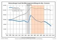
Development of Population since 1875 within the Current Boundaries (Blue Line: Population; Dotted Line: Comparison to Population Development of Brandenburg state; Grey Background: Time of Nazi rule; Red Background: Time of Communist rule)
-
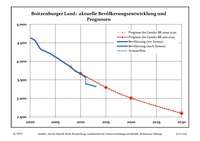
Recent Population Development (Blue Line) and Forecasts
Boitzenburger Land:
Population development within the current boundaries (2013)[2]
| Year |
Population |
|---|
| 1875 | 5 797 |
| 1890 | 5 687 |
| 1910 | 5 234 |
| 1925 | 5 504 |
| 1933 | 4 983 |
| 1939 | 5 019 |
| 1946 | 7 536 |
| 1950 | 7 443 |
| 1964 | 5 677 |
| 1971 | 5 365 |
|
|
| Year |
Population |
|---|
| 1981 | 4 918 |
| 1985 | 5 068 |
| 1989 | 5 256 |
| 1990 | 5 251 |
| 1991 | 5 075 |
| 1992 | 5 069 |
| 1993 | 5 152 |
| 1994 | 5 009 |
| 1995 | 4 997 |
| 1996 | 4 947 |
|
|
| Year |
Population |
|---|
| 1997 | 4 826 |
| 1998 | 4 740 |
| 1999 | 4 631 |
| 2000 | 4 631 |
| 2001 | 4 553 |
| 2002 | 4 343 |
| 2003 | 4 270 |
| 2004 | 4 204 |
| 2005 | 4 119 |
| 2006 | 4 032 |
|
|
| Year |
Population |
|---|
| 2007 | 3 939 |
| 2008 | 3 853 |
| 2009 | 3 732 |
| 2010 | 3 668 |
| 2011 | 3 392 |
| 2012 | 3 360 |
| 2013 | 3 319 |
|
|
References