Blüemlisalp
| Blüemlisalp | |
|---|---|
| Blüemlisalphorn | |
|
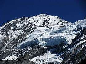
Blüemlisalphorn from the west side | |
| Highest point | |
| Elevation | 3,661 m (12,011 ft) |
| Prominence | 874 m (2,867 ft) [1] |
| Isolation | 7.0 km (4.3 mi) [2] |
| Parent peak | Finsteraarhorn |
| Coordinates | 46°29′19″N 7°46′18″E / 46.48861°N 7.77167°ECoordinates: 46°29′19″N 7°46′18″E / 46.48861°N 7.77167°E |
| Geography | |
 Blüemlisalp Location in Switzerland | |
| Location | Berne, Switzerland |
| Parent range | Bernese Alps |
| Climbing | |
| First ascent | 27 August 1860 by Leslie Stephen, Melchior Anderegg, R. Liveing, F. Ogi, P. Simond and J. K. Stone |
The Blüemlisalp is a massif of the Bernese Alps, in the territory of the municipalities of Kandersteg and Reichenbach im Kandertal.
Its main peaks are:
- Blüemlisalphorn (3,661 m)
- Wyssi Frau (3,648 m) 46°29′35″N 7°47′0″E / 46.49306°N 7.78333°E
- Morgenhorn (3,623 m) 46°29′46″N 7°47′28″E / 46.49611°N 7.79111°E
The entire massif is contained within the canton of Berne, as it lies north of the main crest and water divide of the Bernese Alps. To the west, it is connected with the Doldenhorn group via the Oeschinenhorn and Fründenhorn peaks; to the east, it is continued by the Gspaltenhorn. To the south, it is connected to the main crest by the Tschingel Pass.
Ascent is from the Blüemlisalphütte (2,840 m), over the glacier, past the Wildi Frau (3,260 m)
Geography

The Blüemlisalp forms a ridge of great height, cut away in precipices on the southeast side, surmounted by four principal peaks, in the following order, reckoning from east to west: Morgenhorn (3,623 m), Wyssi Frau (3,648 m), the Blüemlisalphorn (3,661 m) and the Oeschinenhorn (3,486 m). To the southwest of the last peak, and between it and the Doldenhorn, is a minor summit — the Fründenhorn (3,369 m). In front of the main ridge, as seen from the northwest, e. g. from the Dündenhorn, are seen three minor peaks which project as steep islets of rock from the great glacier-fields that cover that side of the mountain. These are the Wildi Frau (3,260 m), the Ufem Stock (3,221 m), and the Blümlisalp Rothhorn (3,297 m).[3]
The two main feeders of the Blüemlisalp Glacier (German: Blüemlisalpgletscher) flow downwards through the openings between the three last-named summits, but a short branch from the ice-stream that descends between the Wildi Frau and the Ufem Stock turns to the north, and flows into the head of the Kiental.[4]
.JPG)
First ascent

The highest peak was ascended in 1860 by Leslie Stephen, accompanied by R. Liveing and J.K. Stone, with Melchior Anderegg and Pierre Simond of Argentière as guides. Starting from the chalets of the Oeschinenalp at 2 a.m., they reached the ridge near the Dündengrat at 4.15. Then mounting over snowfields, and the glacier lying between the Wilde Frau and the Ufem Stock, they passed behind, or south, of the latter summit, and gained the depression between the Blüemlisalp Rothhorn and the highest peak at 6 a.m. They finally reached the top 2 hours laters, Stephen wrote:[4]
- "We reached the top at 8 a.m., and had a grand view down the cliffs to the Tschingel Glacier, as well as a very fine view over the Swiss plains, and a general panorama resembling that from the Altels, returning easily to Kandersteg by 2 p.m."
See also
References
- ↑ Retrieved from the Swisstopo topographic maps. The key col is the Tschingelpass (2,787 m).
- ↑ Retrieved from Google Earth. The nearest point of higher elevation is west of the Breithorn (Lauterbrunnen).
- ↑ Swisstopo map
- 1 2 John Ball, The Alpine Guide, Central Alps, p. 43
External links
| Wikimedia Commons has media related to Blüemlisalp. |
| Wikisource has the text of the 1921 Collier's Encyclopedia article Blümlisalp. |