Biriatou
| Biriatou | |
|---|---|
|
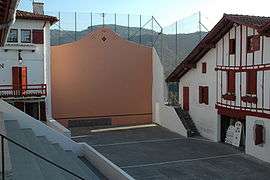
Basque pelota pitch | |
 Biriatou | |
|
Location within Nouvelle-Aquitaine region  Biriatou | |
| Coordinates: 43°20′03″N 1°44′31″W / 43.3342°N 1.7419°WCoordinates: 43°20′03″N 1°44′31″W / 43.3342°N 1.7419°W | |
| Country | France |
| Region | Nouvelle-Aquitaine |
| Department | Pyrénées-Atlantiques |
| Arrondissement | Bayonne |
| Canton | Hendaye |
| Intercommunality | Sud Pays Basque |
| Government | |
| • Mayor (2008–2014) | Michel Hiriart |
| Area1 | 11.04 km2 (4.26 sq mi) |
| Population (2009)2 | 989 |
| • Density | 90/km2 (230/sq mi) |
| Time zone | CET (UTC+1) |
| • Summer (DST) | CEST (UTC+2) |
| INSEE/Postal code | 64130 / 64700 |
| Elevation |
0–552 m (0–1,811 ft) (avg. 100 m or 330 ft) |
|
1 French Land Register data, which excludes lakes, ponds, glaciers > 1 km² (0.386 sq mi or 247 acres) and river estuaries. 2 Population without double counting: residents of multiple communes (e.g., students and military personnel) only counted once. | |
Biriatou (Basque Biriatu) is a village in the traditional Basque province of Labourd, now a commune in the Pyrénées-Atlantiques department in southwestern France.
The village lies on the edge of a hill rising east to the minor mount Xoldokogaina (486 m), the first noticeable prominence across the Spanish-French border at the lower Bidasoa. The hiking trail GR 10 crosses the village, heading east through the southern side of Xoldokogaina.
European road carriers and travellers are acquainted with the name, Basque for 'gate/pass of the way' (bide + ate), on account of the border customs and toll at the AP-8 - A-63 motorway to the west of the actual village, often jammed with vehicles and long queues.
See also
References
External links
| Wikimedia Commons has media related to Biriatou. |
Municipalities in Labourd (Lapurdi) | ||
|---|---|---|
|  | |