Bad Berleburg
| Bad Berleburg | ||
|---|---|---|
 | ||
| ||
 Bad Berleburg | ||
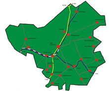
Location of Bad Berleburg within Siegen-Wittgenstein district  | ||
| Coordinates: 51°02′59″N 08°24′00″E / 51.04972°N 8.40000°ECoordinates: 51°02′59″N 08°24′00″E / 51.04972°N 8.40000°E | ||
| Country | Germany | |
| State | North Rhine-Westphalia | |
| Admin. region | Arnsberg | |
| District | Siegen-Wittgenstein | |
| Government | ||
| • Mayor | Bernd Fuhrmann (Ind.) | |
| Area | ||
| • Total | 275.33 km2 (106.31 sq mi) | |
| Population (2015-12-31)[1] | ||
| • Total | 19,774 | |
| • Density | 72/km2 (190/sq mi) | |
| Time zone | CET/CEST (UTC+1/+2) | |
| Postal codes | 57319 | |
| Dialling codes | 02751 | |
| Vehicle registration | SI, BLB | |
| Website | www.bad-berleburg.de | |

Bad Berleburg (![]() , earlier also Berlenburg) is a town, in the district of Siegen-Wittgenstein, in North Rhine-Westphalia, Germany. It is one of Germany's largest towns by land area. It is located approximately 30 km northeast of Siegen and 35 km northwest of Marburg an der Lahn.
, earlier also Berlenburg) is a town, in the district of Siegen-Wittgenstein, in North Rhine-Westphalia, Germany. It is one of Germany's largest towns by land area. It is located approximately 30 km northeast of Siegen and 35 km northwest of Marburg an der Lahn.
Geography
Location

Bad Berleburg lies in the northeast of Siegen-Wittgenstein in the middle of the Rothaargebirge, a low mountain range. The western town limit is also the boundary with the neighbouring district of Olpe. The town is also bordered on the north by the Hochsauerland district. The town's eastern limit is likewise the boundary with the Bundesland of Hesse. The town of Bad Laasphe borders on Bad Berleburg in the south, and the community of Erndtebrück in the southwest.
The small river Odeborn flows through Berleburg and empties into the Eder further south.
Constituent communities
Since 1975, the following villages have been part of Bad Berleburg:
|
|
Population
(in each case at 31 December)
- 1998 - 21,177
- 1999 - 21,190
- 2000 - 21,219
- 2001 - 21,135
- 2002 - 21,022
- 2003 - 20,884
- 2004 - 20,794
History

Archaeological finds confirm that the area covered by today's municipal area was settled as far back as the 7th century BC. On the castle hills at Aue, Dotzlar and Wemlighausen are traces of circular forts from this time. There is, however, no evidence of settlement in the area for the time that follows, up to the 8th century.
The constituent communities of Arfeld and Raumland were mentioned in documents in 800 and 802 respectively. There are also documents from 1059 confirming the existence of Alertshausen, Beddelhausen, Elsoff and Schwarzenau. In 1174, the name "Widechinstein" was mentioned for the first time. The village of Berleburg is mentioned for the first time in 1258 in documents from the Grafschaft Abbey (in this instance Grafschaft is a location rather than the German word for "county"), under the name Berneborg. The castle passed on 30 March 1258 to Count Siegfried I and the "monastery reeve" ("Klostervogt") Adolf von Grafschaft. In 1322, this double overlordship in Berleburg was ended by Widekind von Grafschaft when he forwent his rights to the town in Siegfried II's favour. Siegfried was the last of his noble line, and when he died, the inheritance went to his son-in-law, Salentin von Sayn. He founded the House of Sayn-Wittgenstein.
In 1488, and again in 1522, great fires roared through the town.
Until Count Ludwig the Elder's death in 1605, Berleburg was developing itself into a capital and residence town of the County of Sayn-Wittgenstein-Berleburg, which in the 18th century was a centre in Germany for the Inspiration Movement, which had grown out of radical pietism. Between 1726 and 1742, the well known Berleburg Bible was printed here. Christoph Sauer (1695–1758) lived at Schwarzenau for a few years before emigrating to Pennsylvania in 1724. There in 1743 he would print the first German-language Bible in North America with a press and Fraktur type formerly used by the Berleburg Pietists. Tolerance of religious dissenters ebbed by the mid-1750s.
Wittgenstein was placed under the Grand Duchy of Hesse-Darmstadt in 1806. Under the terms of the Congress of Vienna, it was then ceded to the Prussian province of Westphalia in 1816.
When the Rothaarbahn railway was built to Berleburg in 1911, it brought with it the onset of industrialization, although it was limited to forest products at first. Other forms of industry did not come to town until after the Second World War.
The town was already acknowledged as a climatic spa in 1935 for its gentle and agreeably mild climate. After 1949, the Klinik Wittgenstein was built as a psychosomatic hospital.
In 1951, on private initiative, a Kneipp spa association was founded, which was the forerunner to the Wittgenstein spa institution (Wittgensteiner Kuranstalt; WKA). In the first year that the WKA Kneipp spa works were open, there were 11,000 overnight stays. Little by little, Berleburg became Germany's second largest Kneipp spa.
In 1971, once the town had been granted state recognition as a Kneipp spa, Berleburg was entitled to use the prefix Bad (lit. "bath") with its name, thereby becoming the town of Bad Berleburg, as it has been known ever since. In 1974 also came recognition as a curative spa.
In 1975, with the Sauerland-Paderborn Law, dealing with municipal reform, the surrounding Amt of Berleburg was abolished, and a great deal of it then became part of the town of Bad Berleburg, making the town North Rhine-Westphalia's second largest by land area. The communities of Hoheleye, Langewiese, Mollseifen and Neuastenberg were assigned to the newly established Hochsauerland district. They are today constituent communities of Winterberg. The communities of Balde, Birkelbach, Birkefehl, Leimstruth and Womelsdorf were transferred to the community of Erndtebrück. At the same time, the old district of Wittgenstein was dissolved and added to Siegen district.
In 1984, this district's name was changed to Siegen-Wittgenstein, as it is still called now.
Politics
Town council
The town council's 34 seats were apportioned as of 2009 as follows:
| CDU | SPD | Greens | FDP | UWG | total | |
| 2009 | 15 | 13 | 1 | 2 | 3 | 34 |
Note: UWG is a citizens' coalition.
Coat of arms
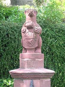
The lion rampant is the mark of the House of Sayn, and the bear stands for the hunt. Some sources, on the other hand, say that it is a canting symbol ("Bear" is Bär in German, pronounced the same way as the first syllable of Berleburg). The House of Wittgenstein is also represented by the pallets (vertical stripes) from their old arms.
Culture and sightseeing
Buildings

- Courtyard of Schloss Wittgenstein- Tours are available to the public at differing times depending on the season for €5, in German only. Note: Do not pick the flowers in the park behind the Schloss.

- Schloss Wittgenstein – a Baroque stately home from 1733 with a museum about the princely house of Sayn-Wittgenstein-Berleburg
- Schulkapelle Sassenhausen (school chapel) – this half-timbered structure was built in 1703 as a church by Mannus Riedesel but was later adapted to house a school as well.
- Ludwigsburg – built for a side branch of the Sayn-Wittgensteins, it is richly embellished on the cornices and corner beams. Also the work of Mannus Riedesel.
Regular events
- Wollmarkt (wool market) – first Sunday in May
- Stünzelfest, menagerie and fair – second Saturday in June
- Berleburger Schützenfest (marksmanship festival) – first weekend in July
- Schützenfest des Schieß- und Schützenverein Wingeshausen 1928 e.V. (marksmanship festival) – fourth weekend in July
- Schützenfest in Müsse des Schieß- und Schützenverein Müsse 1925 e.V. (marksmanship festival) – second weekend in August
Economy and infrastructure
Transport
The municipal area is crossed from north to south by Federal Highway (Bundesstraße) 480, joining Bad Berleburg with Winterberg in the north and Erndtebrück in the south.
The Rothaarbahn railway reaches the town from the south, ending there. Until 31 May 1981 there was a connection from Bad Berleburg to Allendorf and Frankenberg by the Upper Edertalbahn and the Ruhr-Eder-Bahn.
Notable people
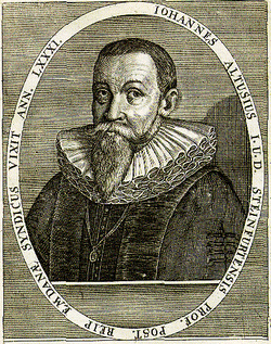
- Johannes Althusius (1563–1638) legal scholar and politician from Bad Berleburg-Diedenshausen
- Lewis Keseberg (1814-1895) emigrated to USA in 1844, famed member of the Donner Party and last member of the Party to be rescued.[2]
- Adolf Kraemer (1832-1910), a Swiss agronomist
- Jacob Nolde (1859–1916) attained great wealth in the United States in the hosiery industry and was an environmentalist largely responsible for the creation of Nolde Forest Environmental Education Center in Pennsylvania.
- Johann Friedrich Henschel (born 1931) born in Bad Berleburg-Schwarzenau, until 1995 vice-president of the Federal Constitutional Court of Germany.
- Gerhard Dickel (1938–2003) born in Bad Berleburg-Girkhausen, Church Music Director, cantor, organist and music professor in Hamburg.
- Hans-Werner Schwarz (born 1946), politician (FDP)
- Paul Breuer (1950-) born in Bad Berleburg-Berghausen, Member of the Bundestag 1980-2003, since 2003 Landrat of the Siegen-Wittgenstein district.
- Norbert Dickel (born 1961) born in Bad Berleburg-Berghausen, German football player, stadium announcer for Borussia Dortmund
- Jürgen Roth (born 1968), writer
- Maik Eckhardt (born 1970) in Bad Berleburg-Berghausen, marksman
- Princess Nathalie of Sayn-Wittgenstein-Berleburg (born 1975) in Copenhagen, dressage rider
- Pia Wunderlich (born 1975) born in Bad Berleburg-Schwarzenau, German football player (since 1993 1. FFC Frankfurt)
- Tina Wunderlich (born 1977) born in Bad Berleburg-Schwarzenau, German football player (since 1994 1. FFC Frankfurt)
- Christina Zerbe (born 1980) from Bad Berleburg-Wingeshausen, former football national player
- Tim Treude (born 1990) in Bad Berleburg-Wingeshausen, football player
Gallery
-

Wunderthausen, chapel
-
between Elsoff and Schwarzenau, street-panorama
-

Dotzlar, view to a street
-
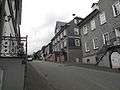
Bad Berleburg, view to a street
-
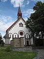
Wemlighausen, chapel
-
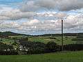
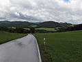
near Landebach, panorama
References
- John Nolde. "Jacob Nolde". Pennsylvania Department of Environmental Protection. Retrieved 2007-01-30.
External links
- Official site (German)
| Wikimedia Commons has media related to Bad Berleburg. |
Towns and municipalities in Siegen-Wittgenstein | ||
|---|---|---|