Belo Horizonte
| Belo Horizonte | |||
|---|---|---|---|
| Municipality | |||
| |||
|
Top left:Church of St. Francis of Assisi, Top right:Rui Barbosa Square (Praça Rui Barbosa), 2nd:Panorama view of Belo Horizonte, from Mangabeiras area, 3rd:Magalhaes Pinto Stadium, Bottom left:Administrative City President Tancredo Neves, Bottom right:Praça da Liberdade (Belo Horizonte Liberty Square) | |||
| |||
|
Nickname(s):
| |||
 Location in Minas Gerais | |||
 Belo Horizonte Location in Brazil | |||
| Coordinates: 19°55′S 43°56′W / 19.917°S 43.933°WCoordinates: 19°55′S 43°56′W / 19.917°S 43.933°W | |||
| Country |
| ||
| Region | Southeast | ||
| State |
| ||
| Founded | 1701 | ||
| Incorporated (as city) | December 12, 1897 | ||
| Government | |||
| • Mayor | Marcio Lacerda (PSB (2013–2016)) | ||
| Area | |||
| • Municipality | 330.9 km2 (127.8 sq mi) | ||
| • Urban | 282.3 km2 (109.0 sq mi) | ||
| • Metro | 9,459.1 km2 (3,652.2 sq mi) | ||
| Elevation | 760 m (2,490 ft) | ||
| Population (2014)[1] | |||
| • Municipality | 2,502,557 | ||
| • Rank | 6th | ||
| • Metro | 5,156,217 (3rd) | ||
| Demonym(s) | Belo-horizontino | ||
| Time zone | BRT (UTC−3) | ||
| • Summer (DST) | BRST (UTC−2) | ||
| Postal Code | 30000-000 | ||
| Area code(s) | (+55) 31 | ||
| Website | Belo Horizonte, MG | ||

.svg.png)
.svg.png)
Belo Horizonte (Portuguese pronunciation: [ˌbɛloɾiˈzõtʃi];[2] Beautiful Horizon) is the sixth largest city in Brazil, the thirteenth largest city in South America and the eighteenth largest city in the Americas. The metropolis is anchor to the Belo Horizonte metropolitan area, ranked as the third most populous metropolitan area in Brazil and the seventeenth most populous in the Americas. Belo Horizonte is the capital of the state of Minas Gerais, Brazil's second most populous state. It is the first planned modern city in Brazil.
The region was first settled in the early 18th century, but the city as it is known today was planned and constructed in the 1890s, in order to replace Ouro Preto as the capital of Minas Gerais. The city features a mixture of contemporary and classical buildings, and is home to several modern Brazilian architectural icons, most notably the Pampulha Complex. In planning the city, Aarão Reis and Francisco Bicalho sought inspiration in the urban planning of Washington, D.C.[3] The city has employed notable programs in urban revitalization and food security, for which it has been awarded international accolades.
The city is built on several hills and is completely surrounded by mountains.[4] There are several large parks in the immediate surroundings of Belo Horizonte. The Mangabeiras Park (Parque das Mangabeiras), located 6 km (4 mi) south-east from the city centre in the hills of Curral Ridge (Serra do Curral), has a very broad view of the city. It has an area of 2.35 km2 (580 acres), of which 0.9 km2 (220 acres) is covered by the native forest. The Jambeiro Woods (Mata do Jambeiro) nature reserve extends over 912 hectares (2,250 acres), with vegetation typical of the Atlantic forest. More than one hundred species of birds inhabit the reserve, as well as ten different species of mammals.
Belo Horizonte was one of the host cities of the 1950 and the 2014 FIFA World Cup. Additionally, the city shared the host of the 2013 FIFA Confederations Cup.
Geography
Surrounding cities and metropolitan area

.jpg)
The term "Grande BH" ("Greater Belo Horizonte") denotes any of various definitions for the metropolitan area of Belo Horizonte. The legally defined Metropolitan Region of Belo Horizonte consists of 34 municipalities in total, and a population of around five million inhabitants (as of 2007, according to IBGE).[5][6]
The intense process of urbanization that is taking place in the metropolitan region has made some of the political boundaries between municipalities in the region obsolete. The city is now composed of a relatively contiguous urban area, centred on Belo Horizonte, which extends out into municipalities such as Contagem, Betim, Nova Lima, Raposos, Ribeirão das Neves, Ibirité, Santa Luzia and Sabará, among others.
The municipality bounded to the north by Vespasiano, to the north east by Santa Luzia, by Sabará to the east, by Nova Lima to the southeast, Brumadinho to the south and Ribeirão das Neves, Contagem and Ibirité to the west.
Geology and geomorphology

Belo Horizonte lies on a region of contact between different geological series of the Proterozoic. The geology largely comprises various crystalline rocks, which give rise to the varied morphology of the landscape. It is located in a large geological unit known as the craton of San Francisco, referring to extensive crustal nucleus of central-eastern Brazil, tectonically stable at the end of the Paleoproterozoic and bordering areas that suffered the regeneration at the Neoproterozoic.
The archean rocks members of Belo Horizonte complex and supracrustal sequences of the Paleoproterozoic is predominant. The area of Belo Horizonte complex includes the geomorphological unit called Depression of Belo Horizonte, which represents about 70% of the municipality area and has its greatest expression in the northern Ribeirão Arrudas (Rues Stream) pipeline. The metasedimentary rocks has its area of occurrence on the south of Ribeirão Arrudas pipeline, constituting about 30% of the area of Belo Horizonte. The characteristics of this area are lithological diversities and rugged topography, which has its maximum expression in the Serra do Curral (Corral Ridge), the southern boundary of the municipality.
Its soil comprises a succession of layers of rocks of varied composition, represented by itabirite, dolomite, quartzite, filities and schists different from the general direction northwest-southeast and dip to the southeast. The hills of Belo Horizonte are part of the Espinhaço Mountains and belong to the larger Itacolomi mountain chain. The highest point in the municipality is in the Serra do Curral, reaching 1,538 metres (5,046 ft).
Climate
Belo Horizonte's latitude at 19'55"South places it in the tropical zone. Yearly temperatures average between 9 and 35 °C (48 and 95 °F). The Köppen climate classification of the region is tropical savanna climate (Aw) and it borders on a humid subtropical climate (Cwa), (tropical on high altitudes, humid/warm summers and a dry/mild winters). Belo Horizonte is located about 300 kilometres (190 mi) from the sea.
Even though inter-seasonal differences are not as pronounced as they are in temperate places, there is a contrast between spring and summer, and between fall and winter. The coldest month is generally July, with a lowest recorded temperature of 2 °C (36 °F). The hottest month is usually January, with a highest recorded temperature of 37.4 °C (99 °F).
The 852-metre (2,795 ft) elevation of Belo Horizonte helps a little in cooling the city, suppressing high maximum air temperatures experienced in nearby cities at lower altitudes. Belo Horizonte's climate is mild throughout the year. Temperatures vary between 11 and 31 °C (52 and 88 °F), the average being 22 °C (72 °F). Winter is dry and mostly sunny, and summer is rainy.
| Climate data for Belo Horizonte | |||||||||||||
|---|---|---|---|---|---|---|---|---|---|---|---|---|---|
| Month | Jan | Feb | Mar | Apr | May | Jun | Jul | Aug | Sep | Oct | Nov | Dec | Year |
| Record high °C (°F) | 35.3 (95.5) |
35.2 (95.4) |
35.2 (95.4) |
32.8 (91) |
32.9 (91.2) |
30 (86) |
32 (90) |
34 (93) |
36.1 (97) |
37.4 (99.3) |
36.2 (97.2) |
35.5 (95.9) |
37.4 (99.3) |
| Average high °C (°F) | 28.2 (82.8) |
28.8 (83.8) |
28.6 (83.5) |
27.5 (81.5) |
26 (79) |
25 (77) |
24.6 (76.3) |
26.5 (79.7) |
27.2 (81) |
27.7 (81.9) |
27.5 (81.5) |
27.3 (81.1) |
27.08 (80.76) |
| Daily mean °C (°F) | 23.5 (74.3) |
23.9 (75) |
23.7 (74.7) |
22.4 (72.3) |
20.5 (68.9) |
19.2 (66.6) |
18.9 (66) |
20.5 (68.9) |
21.7 (71.1) |
22.6 (72.7) |
22.9 (73.2) |
22.9 (73.2) |
21.89 (71.41) |
| Average low °C (°F) | 18.8 (65.8) |
19 (66) |
18.8 (65.8) |
17.3 (63.1) |
15 (59) |
13.4 (56.1) |
13.1 (55.6) |
14.4 (57.9) |
16.2 (61.2) |
17.5 (63.5) |
18.2 (64.8) |
18.4 (65.1) |
16.67 (61.99) |
| Record low °C (°F) | 12.5 (54.5) |
12.8 (55) |
11.7 (53.1) |
6.4 (43.5) |
5 (41) |
2.4 (36.3) |
2.2 (36) |
5.8 (42.4) |
5 (41) |
9.2 (48.6) |
11.4 (52.5) |
12.8 (55) |
2.2 (36) |
| Average precipitation mm (inches) | 296.3 (11.665) |
188.4 (7.417) |
163.5 (6.437) |
61.2 (2.409) |
27.8 (1.094) |
14.1 (0.555) |
15.7 (0.618) |
13.7 (0.539) |
40.5 (1.594) |
123.1 (4.846) |
227.6 (8.961) |
319.4 (12.575) |
1,491.3 (58.713) |
| Average precipitation days (≥ 0.1 mm) | 17 | 13 | 14 | 7 | 6 | 2 | 3 | 4 | 6 | 10 | 14 | 20 | 116 |
| Average relative humidity (%) | 79 | 75.1 | 74.7 | 73.9 | 72.5 | 71.4 | 68.7 | 64.5 | 65.1 | 69.8 | 74.1 | 78 | 72.23 |
| Mean monthly sunshine hours | 189.1 | 197.8 | 213.9 | 228 | 235.6 | 240 | 257.3 | 254.2 | 210 | 189.1 | 183 | 164.3 | 2,562.3 |
| Source #1: World Meteorological Organization.,[7] Hong Kong Observatory (sun only 1961-1990),[8] Climate charts (humidity)[9] | |||||||||||||
| Source #2: Weatherbase (record highs and lows)[10] | |||||||||||||
History
The metropolis was once a small village, founded by João Leite da Silva Ortiz, a bandeirante explorer from São Paulo. The explorer settled in the region in 1701, leaving a gold rush expedition. He then established a farm called "Curral d'el Rey", archaic Portuguese for the "King's Corral", which in modern Portuguese would be spelled Curral do Rei. The farm's wealth and success encouraged people from surrounding places to move into the region, and Curral del Rey became a village surrounded by farms.[11]
Another important factor contributing to the growth of the village was the number of migrants from the São Francisco river region, who had to pass through Curral d'el Rey in order to reach southern parts of Brazil. Travelers usually visited a small wooden chapel, where they prayed for a safe trip. Due to this fact, the chapel was named Capela da Nossa Senhora da Boa Viagem, which means "Chapel of Our Lady of the Good Journey." After the construction of Belo Horizonte, the old baroque chapel was replaced by a neo-gothic church which became the city's cathedral.[12]
The previous capital of Minas Gerais, Ouro Preto (meaning "black gold", due to dark rocks with gold inside found on the region), originally called "Vila Rica" ("wealthy village"), was a symbol of both the monarchic Brazilian Empire and the period when most of Brazilian income was due to mining, and that never pleased the members of the Inconfidência Mineira, republican intellectuals who conspired against the Portuguese dominion of Brazil. In 1889, Brazil became a republic, and it was agreed that a new state capital, in tune with a modern and prosperous Minas Gerais, had to be set.[13]


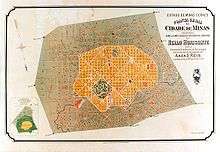
In 1893, due to the climatic and topographic conditions, Curral Del Rey was selected by Minas Gerais governor Afonso Pena among other cities as the location for the new economical and cultural centre of the state, under the new name of "Cidade de Minas," or City of Minas.
Aarão Reis, an urbanist from the State of Pará, was then set to design the second planned city of Brazil (the first one is Teresina), and then Cidade de Minas was inaugurated finally in 1897, with many unfinished constructions as the Brazilian Government set a deadline for its completion. Inhabitation of the city was subsidised by the local government, through the concession of free empty lots and funding for building houses. An interesting feature of Reis' downtown street plan for Belo Horizonte was the inclusion of a symmetrical array of perpendicular and diagonal streets named after Brazilian states and Brazilian indigenous tribes.[14]

In 1906, the name was then changed to Belo Horizonte, and at that time the city was experiencing a considerable industrial expansion that increased its commercial and service sectors. From its very beginning, the city's original plan prohibited workers to live inside the urban area which was defined by Avenida do Contorno (a long avenue which goes around the city's central areas), reserved for the public sector functionaries (hence the name of the still trendy neighbourhood "Funcionários"), and bringing about an accelerated occupation outside the city's area well provided with infrastructure since its very beginning. Obviously, the city's original planners did not count on its population growth afterwards, which proved especially intense in the last twenty years of the 20th century.
In the 1940s, a young Oscar Niemeyer designed the Pampulha Neighbourhood to great acclaim, a commission he got thanks to then-mayor, soon-to-be-president Juscelino Kubitschek. These two men are largely responsible for the wide avenues, large lakes, parks and jutting skylines that characterise the city today.[15]
Belo Horizonte is fast becoming a regional centre of commerce. The Latin American Research and development centre of Google, situated in Belo Horizonte, was responsible for the management and operation of the former social networking website Orkut. It continues to be a trendsetter in the arts, particularly where music, literature, architecture and the avant-garde are concerned.[16]
Demographics


According to the 2010 IBGE Census, there were 2,258,096 people residing in the city of Belo Horizonte.[17] The census revealed the following numbers: 1,110,034 White people (46.7%), 995,167 Pardo (Multiracial) people (41.9%), 241,155 Black people (10.2%), 25,270 Asian people (1.1%), 3,477 Amerindian people (0.1%).[18]
In 2010, the city had 428,893 opposite-sex couples and 1,090 same-sex couples. The population of Belo Horizonte was 53.1% female and 46.9% male.[18]
The Metropolitan Region of Belo Horizonte, called Greater Belo Horizonte, is the 3rd most populous of Brazil, after only Greater São Paulo (with 19,672,582 people, first in Brazil and 5th in the world) and Greater Rio de Janeiro (with 14,387,000 people). The city is the 6th most populous of the country.
During the 18th century, Minas Gerais received many Portuguese immigrants, mainly from Northern Portugal as well as many enslaved Africans.[19]
Belo Horizonte has a notable Italian influence; around 30% of the city's population have some Italian origin.[20] The Italian culture is present in the cuisine, dance, and language.[21] People of German, Spanish, and Syrian-Lebanese ancestries also make up sizeable groups.
Religion
| Religion | Percentage | Number |
|---|---|---|
| Catholic | 59.87% | 1,422,084 |
| Protestant | 25.06% | 595,244 |
| No religion | 8.02% | 190,414 |
| Spiritist | 4.07% | 96,639 |
Economy

Belo Horizonte receives large numbers of visitors, as it is in the Brazilian main economic axis, exerting influence even on other states. Both multinational and Brazilian companies, like Google and Oi, maintain offices in the city. The service sector plays a very important role in the economy of Belo Horizonte, being responsible for 85% of the city's gross domestic product (GDP), with the industry making up for most of the remaining 15%. Belo Horizonte has a developed industrial sector, being traditionally a hub of the Brazilian siderurgical and metallurgical industries, as the state of Minas Gerais has always been very rich in minerals, specifically iron ore.
Belo Horizonte is the distribution and processing centre of a rich agricultural and mining region and the nucleus of a burgeoning industrial complex. Production is centred on steel, steel products, automobiles, and textiles. Gold, manganese, and gemstones mined in the surrounding region are processed in the city.[23] The main industrial district of the city was set during the 1940s in Contagem, a part of greater Belo Horizonte. Multinational companies like FIAT (which opened its plant in Betim in 1974), Arcelor, and Toshiba have subsidiaries in the region, along with other textile like Group Rachelle Textil, Ematex and Cedro Textil, cosmetic, food, chemicals, pharmaceuticals, furnishing and refractory companies. Among the companies headquartered in the city we can list steel producer Açominas (held by Gerdau, one of the largest multinationals originated in Brazil); Usiminas; Belgo-Mineira (held by Arcelor); Acesita (partially held by Arcelor); mobile communication Vivo; and Telecom Italia Mobile, Dasein executive search, executive coaching company, as well as the NYSE-listed electrical company CEMIG. Leading steel product makers Sumitomo Metals of Japan and Vallourec of France have also plans to construct an integrated steel works on the outskirts of the city.

There are also a large number of small enterprises in the technological sector with regional to nationwide success, particularly in the fields of computing and biotechonology. Because of both governmental and private funding in the diversification of its economy, the city has become an international reference in Information Technology and Biotechnology, and is also cited because of the advanced corporate and university research in Biodiesel fuel. The number of jobs in the Information sector has been growing at annual rates above 50%. The Belo Horizonte Metropolitan Area, composed of 33 cities under the capital's direct influence, is home to 16% of the country's biotechnology companies, with annual sales of over R$550 million.[24]
Projects in these fields are likely to expand because of integration between universities, the oil company Petrobras and the Brazilian Government. One of the largest events that ever took place in the city, the Inter-American Development Bank meeting, occurred in 2005 and attracted people from everywhere in the world.
For a long time it was marked by the predominance of its industrial sector, but from the 1990s there has been a constant expansion of the service sector economy, particularly in computer science, biotechnology, business tourism, fashion and the making of jewelry. The city is considered to be a strategic leader in the Brazilian economy. The move towards business tourism transformed the capital into a national hub for this segment of the tourist industry.
- In 2008, the city's GDP was R$42 billion (or about of US$26,2 billion).[25]
- In 2008, the Greater Belo Horizonte's GDP was R$98,5 billion (or about of US$61 billion).[26]
- In 2008, the city's per capita income was R$17,313 (or US$10,820).[27] In 2007, it was R$15,830[28] (about of US$9,893).[28]
Education


Portuguese is the official national language, and thus the primary language taught in schools. English and Spanish are both taught as second languages.
Educational institutions
Several higher education institutions are located in Belo Horizonte, including:
- Universidade Federal de Minas Gerais (UFMG);
- Centro Federal de Educação Tecnológica de Minas Gerais (CEFET-MG);
- Pontifícia Universidade Católica de Minas Gerais (PUC-MG);
- Universidade do Estado de Minas Gerais (UEMG) (State University of Minas Gerais);
- Centro Universitário de Belo Horizonte (UNI-BH);
- Faculdade Pitágoras de Belo Horizonte (FP-BH);
- Faculdades Kennedy (FKBH);
- Centro Universitário (UNA);
- Universidade FUMEC (FUMEC);
- Universidade José do Rosário Vellano (UNIFENAS);
- Centro Universitário Newton Paiva;
- Escola Superior Dom Helder Câmara - Especializada em Direito;
- Faculdade Jesuíta de Filosofia e Teologia (FAJE)
- Skema Business School (SK).
Culture

Food and drink

Belo Horizonte is internationally known as the "capital of neighborhood bars."[30] Every year, the city hosts the Comida di Buteco festival ("Pub Foods", in an approximate translation), in which a panel selects 41 bars to be visited, and then elects the one with the best appetizers using the theme ingredient of each year.
Minas Gerais' cuisine is famous for its traditional dishes, like pão de queijo, feijão tropeiro, tutu de feijão, pork ribs, chicken-and-okra (served with a rich, brown gravy and rice) and other usually heavy, comfort-like food. The city also abounds with pizza places, barbecue houses, fine restaurants of various nationalities and other options.
Music

Clube da Esquina is one of the most important musical movements in the musical history of Brazil. It originated in the mid-1960s, and since then its members have been hugely influential in Brazilian and even international music, some like Milton Nascimento and Toninho Horta achieving worldwide acclaim. Other people involved in the movement include musicians, songwriters, composers, conductors and lyricists, such as Tavinho Moura, Wagner Tiso, Andersen Viana, Milton Nascimento, Lô Borges, Beto Guedes, Flávio Venturini, Toninho Horta, Márcio Borges and Fernando Brant, among others.
The band Uakti - known for performing with self-built musical instruments - originated in Belo Horizonte under the influence of Walter Smetak and the Composition School from Bahia. Also, several nationally famous rock groups have been founded in Belo Horizonte, including Jota Quest, Pato Fu, Skank, 14 Bis and Tianastácia. In later years, Belo Horizonte has been more frequently included in Brazilian tours of foreign mainstream and independent acts.
Belo Horizonte is also known as the Brazilian Capital of Metal, hence the huge number of heavy metal bands (and the likes) founded there, especially in the 1980s. Most importantly, Overdose, the first metal band from BH and one of the first to gain prominence in Brazil; Sepultura, the world's best known Brazilian metal band; and Sarcófago, one of the founders of modern black metal. The contemporary Christian music band Diante do Trono, is also of Belo Horizonte. A short instrumental song by American band Earth, Wind & Fire is named after the city on their album Now, Then & Forever.
Museums

Belo Horizonte features a number of museums including the Mineiro Museum, the Abílio Barreto Historic Museum, Arts and Workmanship Museum, a Natural History Museum and the UFMG Botanic Gardens, a telephone museum, the Pampulha Art Museum, the Professor Taylor Gramke Mineralogy Museum, and the UFMG Conservatory. The puppet theatre group Giramundo was established here in 1970, and continues to maintain a puppetry museum hosting a collection of their creations. There is also The Circuito Cultural Praça da Liberdade, located in the central region of Belo Horizonte is currently the largest cultural circuit in Brazil. In all, there are eleven functioning museums and cultural spaces: Arquivo Público Mineiro (Minas Gerais Public Archive), Biblioteca Pública Estadual Luiz de Bessa (Luiz de Bessa State Public Library), Cefar Liberdade, Centro de Arte Popular Cemig (Cemig Center of Popular Art), Centro Cultural Banco do Brasil (Culture Center Bank of Brazil), Espaço do Conhecimento UFMG (UFMG Knowledge Space), Horizonte Sebrae - Casa da Economia Criativa (Sebrae Horizon - The House of Creative Economy), Memorial Minas Gerais Vale (Minas Gerais Memorial), Museu das Minas e do Metal (Mines and Metal Museum), Museu Mineiro (Minas Gerais Museum) and Palácio da Liberdade (Liberty Palace). Besides these, another three spaces are already in the process of being implemented: the Casa Fiat de Cultura (Fiat Culture House), CENA and Oi Futuro. The proposal, according to the Circuit manager, Cristiana Kumaira, is to strengthen the circuit in the world cultural context. “We are already on this path and are being careful to ensure that the activities, services and assistance fulfill the needs and expectations of both the local population and the tourists who come to Belo Horizonte from different parts of the world. The Circuit is establishing itself as one more source of pride for the people of Minas Gerais”, she stresses. Inaugurated in 2010, the Circuito Cultural Praça da Liberdade was created with the goal of exploring cultural diversity – with interactive options open to the public – in an area of great symbolic, historical and architectural value for Belo Horizonte. The opportunity came with the transference of the Minas Gerais Government headquarters to the Cidade Administrativa (Administrative City), in Serra Verde. After they had been adapted, the old department buildings opened their doors and began to house museums and cultural spaces. The Circuito Cultural Praça da Liberdade is co-managed by the Instituto Sérgio Magnani (Institute) since June, 2012, through a partnership signed with the Minas Gerais Government, and the museums/spaces are mostly run by private companies, which carry out investments in heritage recovery and building maintenance. According to Kumaira, this public-private partnership model allows large companies to participate and effectively contribute to the cultural advance of the city. “Beyond their fields of activities, the partners invest in the implantation and maintenance of museums, learning spaces, exhibitions rooms and shows, as well as memory centers that consolidate the history of Minas Gerais, presenting it either for free or at affordable prices”, she adds. [31]
Natural History Museum and the UFMG Botanic Gardens
The Natural History Museum and Botanical Garden holds an important treasure of folk art – the Nativity of Pipiripau. Created during the 20th century, the craftsman Raimundo Machado, synchronizes 586 figures, distributed in 45 scenes, which tell the story of life and death of Jesus, mixed with its variety of arts and crafts.[32]
With 600,000 sq. m. of green area, the UFMG Museum of Natural History and Botanic Garden (MHN-JB) is a privileged ecological space that enables visitors to experience nature in a rich, multidisciplinary way. For 30 years, the mission of the MHN-JB has been to do research, to educate, and to meet the community’s demand for service. It covers the areas of Anthropology, Archeology, Environmental Education, Natural History, Mineralogy, and Paleontology. It has an Ecological Amphitheater, a Free Art Atelier, a Greenhouse, and an Interactive Room. One of its traditional exhibitions is the Pipiripau Nativity Crèche.It has also created many attractions for the public such as:
Palácio das Artes
Palácio das Artes, inaugurated in 1970, is the largest and most varied cultural complex in Minas Gerais. It comprises three theaters, three art galleries, a movie theater, a bookstore a coffee shop and photography exhibition space. It offers high quality programs for the several expressions in arts. The building was designed by Oscar Niemeyer and it also houses the Minas Gerais Handcraft Center.
Pampulha Art Museum (MAP)
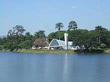
The Pampulha Art Museum is located at the Pampulha Lake in Belo Horizonte in a building that originally housed the Pampulha Casino. The building was designed by Oscar Niemeyer, commissioned by the then mayor and future president of Brazil Juscelino Kubitschek in the early 1940s, with external grounds by landscaper Roberto Burle Marx.
The building was the first project of Oscar Niemeyer, opened as a casino, and closed in 1946. In 1957, it was re-opened as the Art Museum. His design was influenced by the principles of Le Corbusier. The gardens of Burle Marx are an tribute to the tropical green. There is three sculptures by Ceschiatti, Zamoiski and José Pedrosa. In 1996, it won new multimedia rooms, library, café bar, souvenir shop and technical infrastructure. The MAP has an impressive collection of 1.600 works.[33] The Museum is an integral part of the "Pampulha Architectural Complex" a watershed in the history of modern architecture in Brazil and internationally.

Theatre
Every two years, FIT BH, The International Theater Festival of Belo Horizonte, takes place in the city. This attracts artists from all over Brazil and worldwide. With the merger of two projects that would happen separately in 1994, one stage based, organized by the Francisco Nunes Theater, and the other street based, idealized by Grupo Galpão, came FIT-BH Palco & Rua. Produced every two years, under responsibility from the Belo Horizonte City Hall, through the Municipal Culture Office and the Association Movimento Teatro de Grupo of Minas Gerais, in the program there are street and stage shows, and also seminars, workshops, courses, talks, etc.
Dance
.jpg)
.jpg)
Several notable artistic groups originated in Belo Horizonte. Grupo Corpo, which is perhaps the most famous contemporary dance group in the country, was formed in the city in 1975. In March and April is the performance program from FID promoting contemporary dance in Belo Horizonte. The program presents groups from Belo Horizonte. For this project the priority invitations go to the shows created by groups and choreographers living in the city. The purpose is to take shows and other activities such as workshops, talks and video screenings to the less privileged regions of the city regarding access to cultural assets. Belo Horizonte is also host to the Centro Mineiro de Danças Clássicas school.
Architecture
Under the leadership of the then mayor of city, Juscelino Kubitschek, architects and artists such as Oscar Niemeyer, landscaper Burle Marx, and painter Candido Portinari, started a type of modern architecture and art here that was greatly developed later with the construction of Brazil's new capital, Brasilia, also led by the now president Juscelino (aka JK). It is at the Pampulha complex that one can see the routes of this new architecture movement.
The modern and protomodern architecture can also be seen all over Belo Horizonte, either in emblematic 1950's buildings such as Edificio Acaiaca, Conjunto JK, Hotel Amazonas [34] and former Hotel Excelsior,[35] all reflecting the modernity culture of the first planned capital of Brazil.
Transport


Airports
Belo Horizonte is served by three airports:
- Tancredo Neves/Confins International Airport, dedicated to domestic and international traffic. It is located in the municipalities of Lagoa Santa and Confins, 38 kilometres (24 mi) from Belo Horizonte, and was opened in January 1984. Plans for gradual expansion to meet growing demand had been already drawn up from the airport's inception. The airport has one of the lowest rates of shutdown for bad weather in the country. It ran at limited capacity until 2005, when a large proportion of Pampulha Airport air traffic was transferred to Confins. There are direct international flights to/from Miami, Lisbon, Buenos Aires and Panama City.
- Pampulha - Carlos Drummond de Andrade Airport, dedicated to domestic traffic;
- Carlos Prates Airport, dedicated to general aviation.
Highways
The city is connected to the rest of Minas Gerais state and the country by a number of roadways. Minas Gerais has the country's largest federal highway network.[36]
- BR-040 connects Belo Horizonte to Rio de Janeiro (going south) and Brasília (going northwest). It also links other cities in the state, such as Juiz de Fora, Conselheiro Lafaiete, Barbacena, Sete Lagoas, and Paracatu.
- BR-262 begins in Mato Grosso do Sul and ends in Espírito Santo, crossing Minas Gerais from west to east. It links Belo Horizonte to Pará de Minas, Araxá, Manhuaçu, Uberaba, Governador Valadares, and Vitória, the capital of Espírito Santo state.
- BR-381 is an important federal highway. It connects Belo Horizonte to São Paulo.
- MG-010 is a state highway that connects the capital to the Tancredo Neves International Airport, itself located in the municipalities of Confins and Lagoa Santa, which are part of the metropolitan area of Belo Horizonte. Starting in 2005, several flights were transferred from the Pampulha Regional Airport to the international airport. To improve access to the international airport, MG-010 is being expanded (effectively duplicating its lanes).[37]
The city is also served by other minor roads such as state highways MG-020, MG-050, MG-030, and MG-433. There is also an East-West Express Way, which goes from the city to the nearby industrial centres of Contagem and Betim (together having a population of ca. 900,000), and Anel Rodoviário, a kind of "beltway" - indeed it is not circumferential, but connects many highways, such as the federal (BR-ones) so it is not necessary for a large number of cars and trucks to pass through the city centre. Many of these roads are in poor condition, but in the last years many revitalization and rebuilding projects have been started.
Bus system
The bus system has a large number of bus lines going through all parts in the city, and is administrated by BHTRANS. Among the upcoming projects are the expansion of the integration between bus lines and the metro, with integrated stations, many already in use. And the construction of bus corridors, with lanes and bus stops exclusively for the bus lines. Keeping buses from traffic congestions, making the trips more viable for commuters.
Railways
Belo Horizonte Metro or MetroBH started operating at the end of the 1970s. There is one line, with 19 stations, from Vilarinho to Eldorado Station, in Contagem, transporting over 160,000 people daily. The current projects of expansion include Line 2, linking the existing Calafate Station to the region of Barreiro. And Line 3, from the city's main bus terminal to Savassi economical district. Line 2 is planned to be overground (similar to the current line) and Line 3 is planned to be underground, passing through the city's financial centre, Praça Sete and Afonso Pena Avenue. Also, Line 1 is planned to be extended to Novo Eldorado Station.[38]
Landmarks


Belo Horizonte has several significant cultural landmarks, many of them situated in the Pampulha district, where there are notable examples of Brazilian contemporary architecture.[39]
Pampulha Park
The park area includes one of the largest soccer stadiums in the world, the Mineirão stadium, and the São Francisco de Assis Church, widely known as Igreja da Pampulha, designed by Brazilian Modernist architect Oscar Niemeyer. In Pampulha there is also the Universidade Federal de Minas Gerais campus, whose buildings themselves are important contributions to the city's architecture. Other notable buildings include the Mesbla and Niemeyer buildings, in addition to the headquarters of corporations such as Usiminas, Seculus, and Telemig Celular.[40]
Downtown
In the downtown area, landmarks include the church of São José, the Praça da Estação (Station Square), which is an old train station that now is also the Museum of Arts and Workmanship, the Municipal Park, the famous Sete de Setembro Square, where an obelisk built in 1922 marks the one hundred years of Brazilian independence from Portugal.[41]
Near Central the area, in the Lourdes neighborhood, the Lourdes Basilica, is an example of Gothic Revival style. The Nossa Senhora de Fátima Church, in Santo Agostinho neighborhood, is situated in Carlos Chagas Square. Both churches are referred to as the Assembléia Church and the Assembléia Square because of their proximity to the state's legislative assembly.
Next to the downtown region is the famous Savassi district, known for fine restaurants and as a centre of cultural events as well as the best of the city's nightlife. Many landmarks are located there, such as the Praça da Liberdade (Liberty Square), and its surrounding buildings, including the former Executive Offices of the governor called the Palácio da Liberdade (Liberty Palace), the first building to be finished during the city's planned development in the late 1890s. The government offices moved to the "Cidade Administrativa" in 2010. This complex is made by a few massive buildings just outside the city. Nowadays, the "palaces" are being turned into museums. Still on Savassi, the meeting point of many social groups, especially the youth, is "Praça da Savassi" (Savassi Square), which is not exactly a square, and more a crossing between two major avenues (Getúlio Vargas and Cristóvão Colombo), and gathers some of the busiest bars and pubs (called locally "botecos" or "botequins") in town.
Another important landmark is Praça do Papa (Pope's Square), located at a high point south of the downtown area, with its great view of the entire city. It is named for the July 1st, 1980, visit by John Paul II, who held a youth mass there. The nearby Parque das Mangabeiras (Mangabeiras Park) features extensive wildlife, and-owing to its considerable size-has its own bus service, which operates solely within the confines of the park.
On Sundays, Afonso Pena Avenue hosts Latin America's biggest open-air market. This is the Market of Arts and Handicrafts, most commonly known as Feira Hippie (hippie fair). Every Sunday morning 70,000 visitors find food, drinks, clothes, furniture, earrings, shoes and almost anything else.[42]

Zoological Park and Botanical Garden
A centre for conservation and preservation of animals and plants it has also developed environmental education projects. The Zoo, which encompasses a total area of 1.4 million square meters, is located at the Foundation's headquarters and is regarded as one of the most complete in Latin America. It has a collection of close to 900 animals representing 200 species, from Brazil and other parts of the world, as well as the first public butterfly sanctuary in South America.
Pampulha Ecological Park is administered by the Zoo-Botanical Foundation of Belo Horizonte and was inaugurated in May 21 of 2004. It's 30 acres (12 ha) of green area that offers to the population and the tourists a permanent programming of environmental, cultural and patrimonial education.
Human development
The human development of Belo Horizonte varies greatly by locality, reflecting the city's spatial social inequality and vast socioeconomic inequalities. There are neighborhoods that had very high human development indexes in 2000 (equal to or greater than the indexes of some Scandinavian countries), but those in the lower range (in line with, for example, North Africa).[43]
Highest-scoring neighborhoods and localities
Carmo/Sion (0.973): greater than Iceland - 0.968; Cruzeiro/Anchieta/Funcionários (0.970): greater than Iceland - 0.968; Grajau/Gutierrez (0.965): greater than Australia - 0.962; Belvedere/Mangabeiras/Comiteco (0.964): greater than Australia - 0.962; Serra/São Lucas (0.953): equal to Japan, Netherlands - 0.953.
Food as a right
In 1993, under mayor Patrus Ananias de Souza, the city started a series of innovations based on its citizens having the "right to food". These include, for example, creating farmers' markets in the town to enable direct sales and regularly surveying market prices and posting the results across the city.[44] The city's process of participatory budgeting was linked with these innovations, as a result of which the infant mortality rate was reduced by 50% in a decade.[45][46] There is some evidence that these programs have helped support a higher quality of life for the local farmers partnering with the city and that this may be having positive effects on biodiversity in the Atlantic rainforest around the city.[46][47] The city's development of these policies garnered the first "Future Policy Award" in 2009, awarded by the World Future Council, a group of 50 activists (including Frances Moore Lappé, Vandana Shiva, Wes Jackson, and Youssou N'Dour[48]) concerned with the development and recognition of policies to promote a just and sustainable future.
Vila Viva
The city has undertaken an internationally heralded project called Vila Viva ("Living Village" in Portuguese) that promises to "urbanize" the poorest areas (favelas), relocating families from areas with high risk of floods and landslides but keeping them in the same neighborhood, paving main avenues to allow public transportation, police and postal service to have access. All the work is done with 80% of locals, reducing unemployment and increasing family income.[49][50] Former mayor Fernando da Mata Pimentel was nominated for World Mayor in 2005 on the strength of these and other programs.[49]
Sports
Football
As in the rest of Brazil, football is the most popular sport. The city's major teams are Atlético Mineiro, Cruzeiro and América Mineiro.
The city also has one of the biggest football stadiums in the world, the Mineirão, which opened in 1965. The older Independência Stadium was the site of the FIFA World Cup 1950 game, when the United States beat England in a 1–0 win.[51]
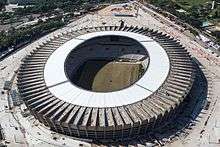
Mineirão, officially called Estádio Governador Magalhães Pinto, was built to provide the city of Belo Horizonte with a larger alternative for Independência Stadium, then the prime venue of the city. The stadium was meant to become the most modern stadium of Brazil and the new home of Atlético Mineiro and Cruzeiro. Construction took almost five years, and on the 5th of September 1965 Mineirão officially opened. Mineirão hardly changed in the following decades, and in the 1990s still had its original capacity. When Brazil won their bid to host the 2014 FIFA World Cup, it was clear that Mineirão needed to undergo a large redevelopment.
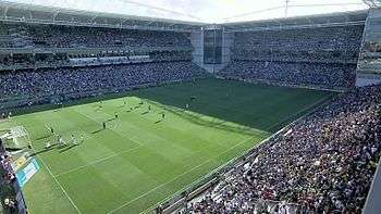
The project included the complete reconstruction of the bottom tier, an extension of the roof, and further refurbishments to upgrade the stadium to FIFA standards. Building works took a total of three years, and were completed in December 2012. The first match at the reopened Mineirão was played on the 3rd of February 2013 with a state championship match between Cruzeiro and Atlético. While Cruzeiro agreed on a lease to play the next 25 years at Mineirão, Atlético have not yet come to an agreement and will keep playing at Independência Stadium until doing so. Mineirão hosted a total of six matches during the 2014 FIFA World Cup, including one round of 16 match and the historical semifinal referred to as Mineirazo in which Brazil lost 1-7 against Germany. The stadium also was one of the playing venues of the 2013 FIFA Confederations Cup.[52]
| Club | League | Venue | Established (team) |
|---|---|---|---|
| Atlético Mineiro | Série A | Independência Stadium
23,018 (32,721 record) |
1908 |
| Cruzeiro | Série A | Mineirão
58,170 (132,834 record) |
1921 |
| América | Série A | Independência Stadium
23,018 (32,721 record) |
1912 |
In addition to football, Belo Horizonte has one of the largest attendances at volleyball matches in the entire country. They are played either at Mineirinho, home of Brazil's national volleyball team, or at Minas Tênis Clube.
Tennis
Belo Horizonte is home to 2015 French Open men's doubles champion and former World no. 1 doubles player Marcelo Melo as well as 2016 Australian Open men's doubles and mixed doubles champion Bruno Soares.
International relations
Twin towns – Sister cities
Belo Horizonte's sister cities are:[53][54]
 San Paolo de Loanda, Angola (1968)
 Zahlé, Lebanon (1974)
 Granada, Spain (1975)
 Porto, Portugal (1986)
 Minsk, Belarus (1987)[55]
 Havana, Cuba (1995)
 Nanjing, China (1996)
 Bethlehem, Palestine (2001)
 Homs, Syria (2001)
 Masaya, Nicaragua (2002)
 Tripoli, Libya (2003)
 Fort Lauderdale, United States (2003)
 Tegucigalpa, Honduras (2004)
 Cuenca, Ecuador (2004)
- Newark, New Jersey, United States (2006)
 Lagos, Nigeria (2011)
References
- ↑ "2014 population estimates. Brazilian Institute of Geography and Statistics (IBGE) (1 July 2014)." (PDF). Ibge.gov.br. Retrieved September 14, 2014.
- ↑ This is the local pronunciation. Elsewhere in Brazil, it is pronounced [bɛlu oɾiˈzõtʃi]. In European Portuguese, it is pronounced [bɛlu oɾiˈzõtɨ]
- ↑ "Belo Horizonte in Brazil Travel". V-brazil.com. Retrieved 2011-04-17.
- ↑ "About Belo Horizonte". World66.com. Archived from the original on 14 May 2011. Retrieved 2011-04-17.
- ↑ "Estimativas / Contagem da População 2007". Instituto Brasileiro de Geografia e Estatística (IBGE). 2007-11-14. Archived from the original on 11 June 2008. Retrieved 2008-05-29.
- ↑ "Tabela 793 - População residente, em 1º de abril de 2007: Publicação Completa". Sistema IBGE de Recuperação Automática (SIDRA). 2007-11-14. Retrieved 2008-05-29.
- ↑ Climate Information for Belo Horizonte, World Weather Information Service, accessed 07 August 2012.
- ↑ Climatological Information for Belo Horizonte, Brazil, Hong Kong Observatory, accessed 07 August 2012.
- ↑ "Belo Horizonte, Brazil: Climate, Global Warming, and Daylight Charts and Data (19°56'S 43°56'W, 850m)". Climate Charts. Retrieved 2014-10-13.
- ↑ "Weatherbase: Historical Weather for Belo Horizonte". Retrieved 2012-08-07.
- ↑ History of BH (English)
- ↑ About Belo Horizonte (English)
- ↑ BH - History (English)
- ↑ History of Belo Horizonte (English)
- ↑ Belo Horizonte, Brazil (English)
- ↑ "History of Belo Horizonte". Belotur.com.br. Retrieved 2011-04-17.
- ↑ Archived May 14, 2012, at the Wayback Machine.
- 1 2 "IBGE :: Censo 2010". Censo2010.ibge.gov.br. Retrieved 2012-11-16.
- ↑ "Portuguese immigration". Asminasgerais.com.br. 2002-02-19. Retrieved 2011-04-17.
- ↑ "Italian origin in BH". Insieme.com.br. Retrieved 2011-04-17.
- ↑ "Italian Culture in BH". Cmbh.mg.gov.br. 2008-04-29. Retrieved 2011-04-17.
- ↑ "Sistema IBGE de Recuperação Automática – SIDRA". Sidra.ibge.gov.br. Retrieved October 11, 2012.
- ↑ "BH city". Darkwing.uoregon.edu. Archived from the original on 13 May 2011. Retrieved 2011-04-17.
- ↑ "Economy of the city of Belo Horizonte". Belotur.com.br. Retrieved 2011-04-17.
- ↑ GDP (PDF) (in Portuguese). Belo Horizonte, Brazil: IBGE. 2006. ISBN 85-240-3919-1. Retrieved 2009-07-21.
- ↑ "Produto Interno Bruto dos Municípios 2002-2005" (PDF). Instituto Brasileiro de Geografia e Estatística (IBGE). Archived from the original (PDF) on 2 October 2008. Retrieved 30 May 2009.
- ↑ per capita income (PDF) (in Portuguese). Belo Horizonte, Brazil: IBGE. 2007. ISBN 85-240-3919-1. Retrieved 2010-01-10.
- 1 2 per capita income (in Portuguese). 2006. Retrieved 2009-07-21.
- ↑ "Regional food and drink BH". World66.com. 2006-09-25. Archived from the original on 14 May 2011. Retrieved 2011-04-17.
- ↑ "Cuisine in Belo Horizonte". Belotur.com.br. Retrieved 2011-04-17.
- ↑ http://en.circuitoculturalliberdade.com.br/plus/modulos/conteudo/index.php?tac=historia&layout=conheca
- ↑ "UFMG Museum of Natural History and Botanic Garden". Belo Horizonte, Brazil. Retrieved September 30, 2011.
- ↑ "Belo Horizonte: um guia completo da capital de todos os mineiros" (PDF). Belo Horizonte, Brazil. Retrieved September 30, 2011.
- ↑ http://www.em.com.br/app/noticia/gerais/2015/07/15/interna_gerais,668573/hotel-no-centro-de-belo-horizonte-abriga-paineis-de-artista-frances.shtml
- ↑ http://www.em.com.br/app/noticia/economia/2013/09/18/internas_economia,450154/hotel-excelsior-vira-residencial-no-centro-de-bh.shtml
- ↑ Tempo bom e trânsito lento marcam volta de feriado (PDF) (in Portuguese). Belo Horizonte, Brazil: Terra. 2007. ISBN 85-240-3919-1. Archived from the original on 7 March 2007. Retrieved 2007-02-22.
- ↑ Linha Verde (PDF) (in Portuguese). Belo Horizonte, Brazil: Governo do Estado de Minas Gerais. 2007. ISBN 85-240-3919-1. Archived from the original on 25 January 2007. Retrieved 2007-01-30.
- ↑ "Metrominas - Trem Metropolitano de Belo Horizonte". Metrominas.mg.gov.br. Retrieved 2012-11-16.
- ↑ Info BH (English)
- ↑ Things of BH (English)
- ↑ Downtown BH (English)
- ↑ FeiraHippiebh.com. "Feira Hippie WebSite". Feirahippiebh.com. Retrieved 2011-04-17.
- ↑ HDI (PDF) (in Portuguese). Belo Horizonte, Brazil: PNUD. 2000. ISBN 85-240-3919-1. Retrieved 2008-01-09.
- ↑ Wayne Roberts and Cecilia Rocha (2008). Belo Horizonte: The Beautiful Horizon of Community Food Sovereignty. Quebec, Canada: Alternatives International Journal. Retrieved 2009-11-10.
- ↑ FRANCIS MOORE LAPPÉ, CounterPunch, 18 March 2009, The City That Ended Hunger
- 1 2 M. Jahi Chappell, PhD Thesis, 2009, From Food Security to Farm to Formicidae: Belo Horizonte, Brazil's Secretaria Municipal de Abastecimento and Biodiversity in the Fragmented Atlantic Rainforest
- ↑ Cecilia Rocha and Adriana Aranha (2003). Urban Food Policies and Rural Sustainability: How the Municipal Government of Belo Horizonte, Brazil is Promoting Rural Sustainability. Toronto, Canada: Centre for Studies in Food Security, and Department of Nutrition, Ryerson University. Archived from the original (PDF) on November 14, 2011. Retrieved 2009-11-10.
- ↑ "Councillors". The World Future Council. Archived from the original on 23 May 2011. Retrieved 2011-04-17.
- 1 2 "Belo Horizonte Mayor Fernando Damata Pimentel: A program of financial efficiency and social boldness". Worldmayor.com. Archived from the original on 14 May 2011. Retrieved 2011-04-17.
- ↑ "Favela é isso ai" (in Portuguese). Favelaeissoai.com.br. 2010-01-18. Retrieved 2011-04-17.
- ↑ Soccerhall (PDF) (in Portuguese). Belo Horizonte, Brazil: Soccerhall. 2005. ISBN 85-240-3919-1. Retrieved 2007-07-18.
- ↑ Mineirão Stadium (English)
- ↑ Prefeitura Municipal de Belo Horizonte. "Relações Internacionais - Cidades Irmãs". Retrieved 29 December 2008.
- ↑ "Mayor's International Council Sister Cities Program". Belo Horizonte, Minas Gerais. Archived from the original on 2007-12-23. Retrieved 2008-08-18.
- ↑ "Twin towns and Sister cities of Minsk [via WaybackMachine.com]" (in Russian). The department of protocol and international relations of Minsk City Executive Committee. Archived from the original on 2 May 2013. Retrieved 2013-07-21.
External links
Official
- (Portuguese) Page of the City Hall of Belo Horizonte
- (Portuguese) Page of the Government of the State of Minas Gerais
Education
- (Portuguese) PUC-MG - the Pontifical Catholic University of Minas Gerais
- (Portuguese) UNI-BH - the University of Belo Horizonte
- (Portuguese) UFMG - Federal University of Minas Gerais
- (Portuguese) CEFET-MG - Federal Center of Technologic Education of Minas Gerais
- (English) Escola Americana de Belo Horizonte - (American School of Belo Horizonte)
- (English) SKEMA Business School (SKEMA Business School)
Photos
Architecture
- (Portuguese) ARQBH
- (Portuguese) Guia Arquitetônico de Belo Horizonte
Tourism
- Tourism Belo Horizonte
- Information about Belo Horizonte
- Travel Information
- AboutBrasil/Belo Horizonte - Metropolis on the Horizon
- (Portuguese) BeloHorizonte.com - City Portal with services and business links
- (Portuguese) Maplink - Belo Horizonte Street Guide and Maps
- (Portuguese) Belo Horizonte Yellow Pages
- (Portuguese) Culture in Belo Horizonte
Food security
- Video about Belo Horizonte's receipt of the World Future Policy award
- Presentations and papers on Belo Horizonte by Brazilian Canadian economist Cecilia Rocha, Toronto Food Policy Council coordinator Wayne Roberts, and former city food security administrator Adriana Aranha at Ryerson University's Centre for Studies in Food Security
- "The City that Ended Hunger", Frances Moore Lappé's essay on Belo Horizonte's programs in Yes! Magazine
Culture
- (Portuguese) Comida di Buteco Festival of bar appetizers.
| Articles Related to Belo Horizonte | ||||||||||||||||||||||||||||||||||||||||||||||||||||||||||||||||||||||||||||||||||||||||||||||||||||||||||||||||||||||||||||||||||||||||||||||||||||||||||||||||||||||||||||||||||||||||||||||||||||||||||||||||||||||||||||||||||||||||||||||||||||||||||||||||||||||||||||||||||||||||||||||||||||||||||||||||||||||||||||||||||||||||||||||||||||||||
|---|---|---|---|---|---|---|---|---|---|---|---|---|---|---|---|---|---|---|---|---|---|---|---|---|---|---|---|---|---|---|---|---|---|---|---|---|---|---|---|---|---|---|---|---|---|---|---|---|---|---|---|---|---|---|---|---|---|---|---|---|---|---|---|---|---|---|---|---|---|---|---|---|---|---|---|---|---|---|---|---|---|---|---|---|---|---|---|---|---|---|---|---|---|---|---|---|---|---|---|---|---|---|---|---|---|---|---|---|---|---|---|---|---|---|---|---|---|---|---|---|---|---|---|---|---|---|---|---|---|---|---|---|---|---|---|---|---|---|---|---|---|---|---|---|---|---|---|---|---|---|---|---|---|---|---|---|---|---|---|---|---|---|---|---|---|---|---|---|---|---|---|---|---|---|---|---|---|---|---|---|---|---|---|---|---|---|---|---|---|---|---|---|---|---|---|---|---|---|---|---|---|---|---|---|---|---|---|---|---|---|---|---|---|---|---|---|---|---|---|---|---|---|---|---|---|---|---|---|---|---|---|---|---|---|---|---|---|---|---|---|---|---|---|---|---|---|---|---|---|---|---|---|---|---|---|---|---|---|---|---|---|---|---|---|---|---|---|---|---|---|---|---|---|---|---|---|---|---|---|---|---|---|---|---|---|---|---|---|---|---|---|---|---|---|---|---|---|---|---|---|---|---|---|---|---|---|---|---|---|---|---|---|---|---|---|---|---|---|---|---|---|---|---|---|---|---|---|---|---|---|---|---|---|---|---|---|---|---|---|---|---|---|---|---|
| ||||||||||||||||||||||||||||||||||||||||||||||||||||||||||||||||||||||||||||||||||||||||||||||||||||||||||||||||||||||||||||||||||||||||||||||||||||||||||||||||||||||||||||||||||||||||||||||||||||||||||||||||||||||||||||||||||||||||||||||||||||||||||||||||||||||||||||||||||||||||||||||||||||||||||||||||||||||||||||||||||||||||||||||||||||||||