Beaucens
| Beaucens | ||
|---|---|---|
|
The village of Beaucens | ||
| ||
 Beaucens | ||
|
Location within Occitanie region  Beaucens | ||
| Coordinates: 42°58′39″N 0°03′35″W / 42.9775°N 0.0597°WCoordinates: 42°58′39″N 0°03′35″W / 42.9775°N 0.0597°W | ||
| Country | France | |
| Region | Occitanie | |
| Department | Hautes-Pyrénées | |
| Arrondissement | Argelès-Gazost | |
| Canton | Argelès-Gazost | |
| Intercommunality | Vallée d'Argelès-Gazost | |
| Government | ||
| • Mayor (2008–2020) | Stéphanie Lacoste | |
| Area1 | 36.82 km2 (14.22 sq mi) | |
| Population (2012)2 | 421 | |
| • Density | 11/km2 (30/sq mi) | |
| Time zone | CET (UTC+1) | |
| • Summer (DST) | CEST (UTC+2) | |
| INSEE/Postal code | 65077 / 65400 | |
| Elevation |
434–2,637 m (1,424–8,652 ft) (avg. 480 m or 1,570 ft) | |
|
1 French Land Register data, which excludes lakes, ponds, glaciers > 1 km² (0.386 sq mi or 247 acres) and river estuaries. 2 Population without double counting: residents of multiple communes (e.g., students and military personnel) only counted once. | ||

Beaucens (Occitan: Biussens) is a French commune in the Hautes-Pyrénées department in the Occitanie region of south-western France.[1]
The inhabitants of the commune are known as Beaucinois or Beaucinoises.[2]
Geography
Beaucens is located in the Pyrénées National Park some 10 km south of Lourdes and 30 km south of Tarbes. Access to the commune is by the D913 from Préchac in the north which passes through the west of the commune and the village and continues south to join the D921 south-east of Soulom. The D13 goes north from the village to Ayros-Arbouix. Apart from the village there are the hamlets of Vielle, Gézat, and Nouillan. Most of the commune is rugged and inaccessible with some farmland in the west and forests south-east of the village. The Hautacam Ski resort is located in the centre of the commune[3][4]
The Gave du Pau Ou du Lavedan flows through the west of the commune from south to north forming the Lac des Gaves before continuing north to become the Gave de Pau north of the commune. The Ruisseau des Bariquėres rises in the west of the commune and flows east to join the Gave du Pau Ou du Lavedan west of the village. The Ruisseau d'Estibos rises in the east of the commune and forms part of the north-eastern border before continuing west to join the Gave du Pau Ou du Lavedan. The Ruisseau d'Isaby flows east from the Lac d'Isaby forming part of the south-eastern border of the commune as it flows south-west to join the Gave de Gavarnie Ou de Pau at Soulom.[3][4]
Mapping
A list of online mapping systems can be displayed by clicking on the coordinates (latitude and longitude) in the top right hand corner of this article.
Neighbouring communes and villages
 |
Préchac | Germs-sur-l'Oussouet | Campan | |
| Bun | |
Arreau | ||
| ||||
| | ||||
| Estaing | Viscos | Barèges |
Toponymy
- Historical names
- [5]
- Belsen, (around 870, Livre vert de Bénac, around 980, ibid;. 1050-1070, Cartulary of Saint-Savin; 1168, Papal bull of Pope Alexander III).
- Beusen, (1285, Montre Bigorre; 1300, Enquête Bigorre; 1313 Debita regi Navarre;).
- de Beucennio, Latin (1379 procuration of Tarbes).
- Beucen, Beussen, Beusen (1429 Censier de Bigorre).
- Beaussen, Beaucen, (1614, Guillaume Mauran).
- Beaucen en Lavedan, (1737-1779, parish records).
- Beucen, (1768, Duco).
- Beaucen, (1790, Department 1 and 2).
Beaucens appears as Beaucen on the 1750 Cassini Map[6] and the same on the 1790 version.[7]
Heraldry
.svg.png) |
Blazon: Party per pale, Argent, a crow sable posed on a branch Vert and surmounted by 2 crows sable in fess first; paly of 9 Or and Gules second. |
Administration
| From | To | Name | Party | Position |
|---|---|---|---|---|
| 1995 | 1995 | André Ducasa | ||
| 1995 | 2001 | Claude Vielle | ||
| 2001 | 2008 | Monique Arrode | ||
| 2008 | 2008 | Claude Bat | ||
| 2008 | 2020 | N | Stéphanie Lacoste |
(Not all data is known)
Demography
In 2012 the commune had 421 inhabitants. The evolution of the number of inhabitants is known from the population censuses conducted in the commune since 1793. From the 21st century, a census of communes with fewer than 10,000 inhabitants is held every five years, unlike larger communes that have a sample survey every year.[Note 1]
| 1793 | 1800 | 1806 | 1821 | 1831 | 1836 | 1841 | 1846 | 1851 |
|---|---|---|---|---|---|---|---|---|
| 379 | 402 | 435 | 460 | 491 | 491 | 488 | 502 | 470 |
| 1856 | 1861 | 1866 | 1872 | 1876 | 1881 | 1886 | 1891 | 1896 |
|---|---|---|---|---|---|---|---|---|
| 463 | 457 | 468 | 441 | 445 | 417 | 380 | 365 | 346 |
| 1901 | 1906 | 1911 | 1921 | 1926 | 1931 | 1936 | 1946 | 1954 |
|---|---|---|---|---|---|---|---|---|
| 335 | 342 | 311 | 283 | 265 | 361 | 271 | 237 | 244 |
| 1962 | 1968 | 1975 | 1982 | 1990 | 1999 | 2007 | 2012 | - |
|---|---|---|---|---|---|---|---|---|
| 260 | 247 | 244 | 249 | 309 | 350 | 437 | 421 | - |
Sources : Ldh/EHESS/Cassini until 1962, INSEE database from 1968 (population without double counting and municipal population from 2006)

Culture and heritage
Civil heritage
The commune has two buildings and sites that are registered as historical monuments:
- The Manor of Cohitte (1692)
 [9]
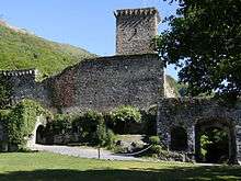
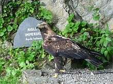
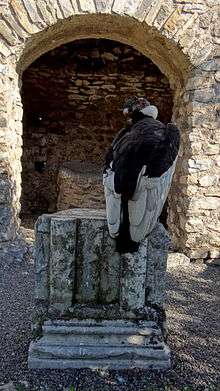
[9] - The Chateau of Beaucens (ruins) (14th century)[10] is a former castle of the Viscounts of Lavedan. The site was transformed into a zoo, the Keep of Eagles, where there are Birds of prey flying around the ruins of the castle with a view of the Gaves valley.
Religious heritage
The Church of Saint Vincent contains two items that are registered as historical objects:
See also
Notes and references
Notes
- ↑ At the beginning of the 21st century, the methods of identification have been modified by Law No. 2002-276 of 27 February 2002, the so-called "law of local democracy" and in particular Title V "census operations" allows, after a transitional period running from 2004 to 2008, the annual publication of the legal population of the different French administrative districts. For communes with a population greater than 10,000 inhabitants, a sample survey is conducted annually and the entire territory of these communes is taken into account at the end of the period of five years. The first "legal population" after 1999 under this new law came into force on 1 January 2009 and was based on the census of 2006.
References
- ↑ Beaucens on Lion1906
- ↑ Inhabitants of Hautes-Pyrénées (French)
- 1 2 3 Beaucens on Google Maps
- 1 2 Beaucens on the Géoportail from National Geographic Institute (IGN) website (French)
- ↑ Michel Grosclaude, Jean-François Le Nail, Jacques Boisgontier, Toponymic Dictionary of communes of Hautes-Pyrénées, Conseil général des Hautes-Pyrénées, 2000, 348 pages, ISBN 2951481012, 9782951481015 (French)
- ↑ Beaucen on the 1750 Cassini Map
- ↑ Beaucen on the 1790 Cassini Map
- ↑ List of Mayors of France (French)
- ↑ Ministry of Culture, Mérimée PA65000006 Manor of Cohitte (French)
- ↑ Ministry of Culture, Mérimée PA00095344 Chateau (French)
- ↑ Ministry of Culture, Palissy PM65000120 Altar table
 (French)
 - ↑ Ministry of Culture, Palissy PM65000119 Notre-Dame-de-Bedouret Statue
(French)
| Wikimedia Commons has media related to Beaucens. |