Bayrampaşa
| Bayrampaşa | |
|---|---|
| district | |
 | |
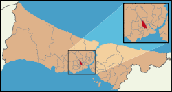 Location within Istanbul | |
 Bayrampaşa Location within Istanbul | |
| Coordinates: 41°02′53″N 28°54′01″E / 41.04806°N 28.90028°ECoordinates: 41°02′53″N 28°54′01″E / 41.04806°N 28.90028°E | |
| Country | Turkey |
| City | Istanbul |
| Government | |
| • Mayor | Atila Aydıner (AKP) |
| • Governor | Abdulkadir Yazıcı |
| Area[1] | |
| • District | 6.98 km2 (2.69 sq mi) |
| Elevation | 17 m (56 ft) |
| Population (2012)[2] | |
| • Urban | 269,774 |
| • District | 269,774 |
| • District density | 39,000/km2 (100,000/sq mi) |
| Time zone | EET (UTC+2) |
| • Summer (DST) | EEST (UTC+3) |
| Area code(s) | 0-212 |
| Website |
www |
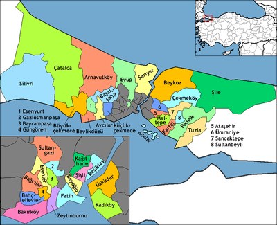
Bayrampaşa (pronounced [bajˈɾampaʃa]) is a suburban district of Istanbul, Turkey on the European side of the city. The district comprises both working class residential and industrial areas. The population is 240,000 (1997), and the district covers an area of 8 km2 (3.1 sq mi). The mayor is Atila Aydıner (AKP). It was part of Fatih district till 1936 and Eyüp one between 1936 and 1990. Former name of Bayrampaşa was "Sağmalcılar" till 1960s. Its neighbours are Gaziosmanpaşa from north, Eyüp from east, Zeytinburnu from south and Esenler from west.
The people of Bayrampaşa are mainly Albanians and Bosniaks.[3] The housing in Bayrampaşa is generally poor quality and there are workshops and small factories even in the residential streets, while large areas of the district are purely industrial.
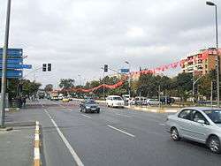
There are a number of important public buildings in the area: Istanbul's largest prison (that has been now idled); two large sports complexes; the main bus station (which is actually in Bayrampaşa although it is named Esenler bus station). Bayrampaşa lies on the route of the old road to Thrace and a number of major roads and a light railway run through the middle of the area.
The area was known as Sağmalcılar until 1970, when a large outbreak of cholera, caused by pollution of the Ottoman-built water supply by new buildings and factories, led to the area being quarantined. Following this incident, the name Sağmalcılar became synonymous with cholera, so the district was renamed Bayrampaşa, after the 17th-century Ottoman grand vizier Bayram Pasha. Little of the Ottoman water system, which was built by Mimar Sinan, remains today.
Bayrampaşa is famous for its artichokes produced in the past, but now although there is no production in the region its name is given to a variety of artichoke in Turkey. Also there is a large statue of an artichoke in the middle of the district which became a symbol of the region.
The local football team based in the district is called Bayrampaşaspor.
On 1 December 2015, an explosion occurred near Bayrampaşa metro station, leaving several injured.[4]
References
- ↑ "Area of regions (including lakes), km²". Regional Statistics Database. Turkish Statistical Institute. 2002. Retrieved 2013-03-05.
- ↑ "Population of province/district centers and towns/villages by districts - 2012". Address Based Population Registration System (ABPRS) Database. Turkish Statistical Institute. Retrieved 2013-02-27.
- ↑ Elma Gabela (5 June 2011). "Turkey's Bosniak communities uphold their heritage, traditions". Today's Zaman. Retrieved 2011-09-20.
- ↑ "Istanbul metro blast 'causes injuries' - Turkey media". BBC News. 1 December 2015. Retrieved 1 December 2015.
- "Information on Bayrampaşa district" (in Turkish). Governorship of Istanbul. 2009. Archived from the original on 2009-12-13. Retrieved 2009-08-16.
External links
- District governor's official website (Turkish)
- District municipality's official website (Turkish)
- Miscellaneous images of Bayrampaşa