Batanes
| Batanes | |||
|---|---|---|---|
| Province | |||
| Province of Batanes | |||
| |||
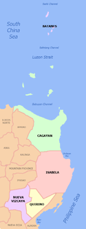
 Location in the Philippines | |||
| Coordinates: 20°35′N 121°54′E / 20.58°N 121.9°ECoordinates: 20°35′N 121°54′E / 20.58°N 121.9°E | |||
| Country | Philippines | ||
| Region | Cagayan Valley (Region II) | ||
| Founded | 1909 | ||
| Capital | Basco | ||
| Government | |||
| • Type | Sangguniang Panlalawigan | ||
| • Governor | Marilou Cayco (Liberal) | ||
| • Vice Governor | Ronald Aguto (Independent) | ||
| Area[1] | |||
| • Total | 219.01 km2 (84.56 sq mi) | ||
| Area rank | 81st out of 81 | ||
| Population (2015 census)[2] | |||
| • Total | 17,246 | ||
| • Rank | 81st out of 81 | ||
| • Density | 79/km2 (200/sq mi) | ||
| • Density rank | 73rd out of 81 | ||
| Divisions | |||
| • Independent cities | 0 | ||
| • Component cities | 0 | ||
| • Municipalities |
6
| ||
| • Barangays | 29 | ||
| • Districts | Lone district of Batanes | ||
| Time zone | PHT (UTC+8) | ||
| ZIP code | 3900–3905 | ||
| IDD : area code | +63 (0)78 | ||
| ISO 3166 code | PH-BTN | ||
| Spoken languages | |||


Batanes (Ivatan: Probinsya nu Batanes; Ilocano: Probinsya ti Batanes; Filipino: Lalawigan ng Batanes) is an archipelago province in the Philippines situated in the Cagayan Valley region. It is the northernmost province in the country, and also the smallest, both in population and land area. Its capital is Basco located in the island of Batan.
The island group is located approximately 162 kilometres (101 mi) north of the Luzon mainland and about 190 kilometres (120 miles) south of Taiwan, separated from the Babuyan Islands of Cagayan Province by the Balintang Channel, and from Taiwan by the Bashi Channel.
History
The ancestors of today's Ivatans descended from Austronesians who migrated to the islands 4,000 years ago during the Neolithic period. They lived in fortified mountain areas called idjangs and drank sugar-cane wine, or palek. They also used gold as currency and produced a thriving agriculture-based industry. They were also seafarers and boat-builders.
In 1687, a crew of English freebooters headed by William Dampier came with a Dutch crew and named the islands in honour of their country's nobility. Itbayat was named "Orange Isle" after William of Orange, and Batan was named "Grafton Isle" after Henry FitzRoy, 1st Duke of Grafton. Sabtang Isle was named "Monmouth Isle" after James Scott, 1st Duke of Monmouth. Capt. Dampier stayed for less than three months, and did not claim the islands for the British crown.
In 1783, the Spanish claimed Batanes as part of the Philippines under the auspices of Governor-General José Basco y Vargas. The Bashi Channel was increasingly used by English East India Company ships and the Spanish authorities brought the islands under their direct administration to prevent them falling under British control.[3] However, the Ivatan remained on their idjangs, or mountain fortresses. In 1790, Governor Guerrero decreed that Ivatans were to leave their idjang and to live in the lowlands, thereby giving them more people to tax. Basco and Ivana were the first towns. Mahatao was then administered by Basco, while Uyugan and Sabtang, by Ivana. Itbayat was not organized until the 1850s, its coast being a ridge. Ivatans were ordered to dress like the other Filipinos, and it didn't take them long to adapt. Soon, Ilocanos were being put in the islands, so as to control the native population there. Limestone technology used by the Spanish also spread to the islands, so that their bridges became strong and fortified. Some of these bridges still remain at Ivana and Mahatao. By 1890, many Ivatans were in Manila, and became ilustrados, who then brought home with them the revolutionary ideas of the Katipunan. These Ivatans, who were then discontented with Spanish rule, killed the ruling General Fortea and declared the end of Spanish rule.
Toward the end of the Spanish regime, Batanes was made a part of Cagayan. In 1909, the American authorities organized it into an independent province. During the American colonial period, public schools were constructed and more Ivatan became aware of their place in the Philippines. In 1920, the first wireless telegraph was installed, followed by an airfield in 1930. Roads were constructed and the Batanes High School was instituted.
Because of their strategic location, the islands was one of the first points occupied by invading Japanese imperial forces at the outbreak of the Pacific War. The morning of December 8, 1941, the Batan Task Force from Taiwan landed on the Batan Islands, which became the first American territory occupied by the Japanese. The purpose of the invasion was to secure the existing small airfield outside Basco, which was accomplished without resistance. Japanese fighters from Basco took part in the raid on Clark Air Base the following day. However, over the next several days, the success of the Japanese bombing of Clark Field rendered a base at Basco unnecessary, and on December 10, 1941, the naval combat force was withdrawn to participate in the invasion of Camiguin.[4]
One of the first School Superintendents on Batan was Victor de Padua, an Ilocano, who in 1942-45 during the Japanese occupation was made Provincial Governor.
Early in 1945 the island was liberated by the Philippine Commonwealth forces of the 1st and 12th Infantry Division of the Philippine Commonwealth Army.
On July 23, 2007, a magnitude-5.2 quake rocked Batanes, but no damage or casualties were immediately reported. The United States Geological Service said the quake was recorded at about 10:58 a.m., with the epicenter at 40 km south of Basco town in Batanes, about 250 km northeast of Laoag, Ilocos Norte; or 560 km south of Taipei, Taiwan.[5]
On June 1, 2008, a magnitude 6.3 earthquake struck the seabed off the coast of Batanes, but no injuries or damage was reported.[6]
Geography
The province has a total area of 219.01 square kilometres (84.56 sq mi)[7] comprising ten islands situated within the Luzon Strait between the Babuyan Islands (belonging to Cagayan province) and Taiwan. The islands are sparsely populated and subject to frequent typhoons. The three largest islands, Batan, Itbayat, and Sabtang, are the only inhabited islands.
The northernmost island in the province, also the northernmost land in the entire Philippines, is Mavudis Island. Other islands in the chain are Misanga, Siayan, Ivuhos, and Dequey.[8] The islands are part of the Luzon Volcanic Arc.
Topography
Almost one-half of Batanes are hills and mountains. Batan Island, with a land area of 35 square kilometres (14 sq mi), is generally mountainous on the north and southeast. It has a basin in the interior. Itbayat Island, which has a total area of 95 square kilometres (37 sq mi), slopes gradually to the west, being mountainous and hilly along its northern, eastern coast. As for Sabtang, mountains cover the central part of its 41 square kilometres (16 sq mi) area, making the island slope outward to the coast.
The islands are situated between the vast expanse of the waters of Bashi Channel and Balintang Channel, where the Pacific Ocean merges with the China Sea. The area is a sealane between the Philippines and Japan, China, Hong Kong and Taiwan. It is rich with marine resources, including the rarest sea corals in the world.

The province is hilly and mountainous, with only 1,631.5 hectares or 7.1% of its area level to undulating and 78.2% or 17,994.4 hectares varying in terms from rolling to steep and very steep. Forty two percent (42%) or 9,734.40 hectares are steep to very steep land. Because of the terrain of the province, drainage is good and prolonged flooding is non-existent. The main island of Batan has the largest share of level and nearly level lands, followed by Itbayat and Sabtang, respectively. Itbayat has gently rolling hills and nearly level areas on semi-plateaus surrounded by continuous massive cliffs rising from 20 to 70 metres (66–230 feet) above sea level, with no shorelines. Sabtang has its small flat areas spread sporadically on its coasts, while its interior is dominated by steep mountains and deep canyons. Batan Island and Sabtang have intermittent stretches of sandy beaches and rocky shorelines.
The terrain of the province, while picturesque at almost every turn, has limited the potential for expansion of agriculture in an already very small province.
Climate
Batanes has a tropical climate (Köppen climate classification Af). The average yearly temperature is 26.0 °C (78.8 °F), and the average monthly temperature ranges from 22.0 °C (71.6 °F) in January to 28.5 °C (83.3 °F) in July, similar to that of Southern Taiwan. Precipitation is abundant throughout the year; the rainiest month is August while the driest month is April. November to February are the coldest months. There is a misconception that Batanes is constantly battered by typhoons. Batanes is mentioned frequently in connection with typhoons because it holds the northernmost weather station in the Philippines and is thus a reference point for all typhoons that enter the Philippine area. However, in September 2016, Typhoon Meranti impacted the entire province, including a landfall on Itbayat.[9]
| Climate data for Basco, Philippines (1961-1990) | |||||||||||||
|---|---|---|---|---|---|---|---|---|---|---|---|---|---|
| Month | Jan | Feb | Mar | Apr | May | Jun | Jul | Aug | Sep | Oct | Nov | Dec | Year |
| Average high °C (°F) | 24.9 (76.8) |
25.9 (78.6) |
27.6 (81.7) |
29.6 (85.3) |
31.3 (88.3) |
31.7 (89.1) |
31.9 (89.4) |
31.2 (88.2) |
31.2 (88.2) |
29.8 (85.6) |
27.7 (81.9) |
25.6 (78.1) |
29.0 (84.2) |
| Daily mean °C (°F) | 22.0 (71.6) |
22.9 (73.2) |
24.4 (75.9) |
26.5 (79.7) |
28.1 (82.6) |
28.5 (83.3) |
28.5 (83.3) |
28.1 (82.6) |
27.9 (82.2) |
26.7 (80.1) |
24.9 (76.8) |
22.9 (73.2) |
26.0 (78.8) |
| Average low °C (°F) | 19.2 (66.6) |
19.8 (67.6) |
21.2 (70.2) |
23.3 (73.9) |
24.8 (76.6) |
25.3 (77.5) |
25.2 (77.4) |
24.9 (76.8) |
24.5 (76.1) |
23.6 (74.5) |
22.2 (72) |
20.1 (68.2) |
22.8 (73) |
| Average rainfall mm (inches) | 178.0 (7.008) |
122.7 (4.831) |
91.4 (3.598) |
70.3 (2.768) |
169.7 (6.681) |
258.4 (10.173) |
279.4 (11) |
419.6 (16.52) |
380.4 (14.976) |
328.1 (12.917) |
296.9 (11.689) |
253.0 (9.961) |
2,847.9 (112.122) |
| Average rainy days | 18 | 14 | 10 | 8 | 10 | 14 | 15 | 20 | 18 | 18 | 19 | 19 | 183 |
| Source: Hong Kong Observatory [10] | |||||||||||||
Administrative divisions
Batanes is subdivided into 6 municipalities, all encompassed by a lone congressional district.
|
←
→
→
←
(clickable map)
| |||||||||||||||||||||||||||||||||||||||||||||||||||||||||||||||||||||||||||||||||||||||||||||||||||||||||||||||||||||||||||||||||||||
Barangays
The 6 municipalities of the province comprise a total of 29 barangays, with Ihubok II in Basco as the most populous in 2010, and Nakanmuan in Sabtang as the least.[11]
Demographics
| Population Census of Batanes | ||
|---|---|---|
| Year | Pop. | ±% p.a. |
| 1990 | 15,026 | — |
| 1995 | 14,180 | −1.08% |
| 2000 | 16,467 | +3.26% |
| 2007 | 15,974 | −0.42% |
| 2010 | 16,604 | +1.42% |
| 2015 | 17,246 | +0.72% |
| Source: National Statistics Office[2][11][11] | ||
The population of Batanes in the 2015 census was 17,246 people,[2] with a density of 79 inhabitants per square kilometre or 200 inhabitants per square mile.

The natives are called The Ivatans and share prehistoric cultural and linguistic commonalities with the Babuyan on Babuyan Island and the Tao people of Orchid Island.
This divided homeland is a result of the Dutch invasion of Taiwan in 1624 (Dutch Formosa) and Spanish invasion in 1626 (Spanish Formosa). The northern half of the Ivatan homeland, Formosa and Orchid Island which were formally part of the Viceroyalty of New Spain, fell to the Dutch who were in turn expelled in 1662 by forces of the Chinese Southern Ming dynasty, led by the Chinese pirate Koxinga who then set himself up as The King of Taiwan.
The southern half of the Ivatan homeland, the islands of Batanes, was reinforced and fortified by Spanish refugees from Formosa before being formally joined in the 18th century with the Spanish government in Manila.
The main languages spoken in Batanes are Ivatan, which is spoken on the islands of Batan and Sabtang, Itbayaten, which is spoken primarily on the island of Itbayat, and Ilocano. The Ivatan which is dominant in the province is considered to be one of the Austronesian languages. From college level down to elementary level, the language is widely spoken.[12]
Religion
The large majority (94%) of the island's people adhere to Roman Catholicism. The remaining faiths are other Christian Churches.
Ecology

An extensive survey of the ecology of Batanes[13] provided the scientific basis for confirming the need for a national park in Batanes protecting the Batanes protected landscapes and seascapes, proposed as a UNESCO World Heritage Site, submitted on 15 August 1993. The whole province, along with the sugar central sites in Negros, are currently being pushed in UNESCO to be declared UNESCO World Heritages Sites by the end of 2020.[14]
Flora and fauna
The province is the home of the unique conifer species Podocarpus costalis. Although it is reportedly growing in some other places such as coasts of Luzon, Catanduanes and even Taiwan, full blossoming and fruiting are observed only in Batanes. Its fruiting capacity on the island remains a mystery but some consider several factors such as climate, soil and type of substratum of the island.
Several species of birds, bats, reptiles and amphibians also inhabit the island; many of those are endemic in the Philippines. The island is also a sanctuary of different migratory birds during winter in the Northern Hemisphere.
Economy
About 75% of the Ivatans are farmers and fishermen. The rest are employed in the government and services sector. Garlic and cattle are major cash crops. Ivatans also plant camote (sweet potato), cassava, gabi or tuber and a unique variety of white uvi. Sugarcane is raised to produce palek, a kind of native wine, and vinegar.
In recent years, fish catch has declined due to the absence of technical know-how. Employment opportunities are scarce. Most of the educated Ivatans have migrated to urban centers or have gone abroad.
A wind diesel generating plant was commissioned in 2004.
Distance and bad weather work against its economic growth. Certain commodities like rice, soft drinks, and gasoline carry a 75% to 100% mark-up over Manila retail prices.
Transportation
The island province of Batanes is accessible by air via the Basco Airport and Itbayat Airport. There are 3 flights per week from Manila by SkyJetAir, and from Tuguegarao (Cagayan) by small local airliners (as of January 2013). PAL Express flies to Batanes every Monday, Wednesday, and Friday since May 1, 2013.[15]
Tourist Attractions

- Sabtang Island is undisturbed and unspoiled. The island has natural attractions guaranteed to satisfy the most sophisticated nature lovers. It has intermittent white sand beaches with steep mountains and deep canyons with small level areas sporadically found along the coastline. Southwest of Batan Island, Sabtang is accessible by 30-minute falowa ride from Radiwan Port in Ivana. Sabtang Island is also the take off point for Ivuhos Island from Barangay Nakanmuan.
- Itbayat Island is located north of Batan Island. Itbayat is shaped like a giant bowl. The island is surrounded by massive boulders and cliffs rising from 20 to 70 feet (6.1–21.3 metres) above sea level and has no shoreline. It has a dirt airstrip for light aircraft. A regular ferry runs the Batan-Itbayat route. Travel time is about four hours on falowa from Basco Seaport or Radiwan Port in Ivana. A light plane flies from Basco Airport to Itbayat at P1,875 per person and leaves only when the plane is full.
- Batan Island is the most populated island of the province. It is composed of four municipalities namely Basco, Ivana, Uyugan and Mahatao. Basco is the center of commerce and seat of the provincial government.
- Mount Iraya is a dormant volcano standing at 1,517 metres (4,977 feet) whose last eruption was recorded in 505 AD. Mountaineering, trekking and trailblazing are recommended sports activities on the mountain. Walking distance from Basco, the top of Mt. Iraya can be reached in about three hours.
- Yami/Amianan is the northernmost island of Batanes. It is also called the Orchid Island. One can see Formosa (Taiwan) on a clear day. Tatus or coconut crabs abound in the island surrounded by rich marine life.
- Di-atay Beach is a cove with multi-colored rocks and white sand ideal for picnics and beach combing. Located along the highway of Mahatao, it is 9.85 kilometres (6.12 miles) from Basco.
- Songsong in Chadpidan Bay is an hour of exhilarating trek from Basco proper (3 kilometres (1.9 miles)). It is famous for its beautiful sunset view.
- Naidi Hills is walking distance from Basco.
- Chawa Cave is for the more adventurous. An enchanted cave with a natural salt bed whose mouth opens to the south China Sea and is accessible through the boulders of Chawa Point in Mahatao. It is 4km from Basco.
- Sitio Diura at Racuj-a-Ide is the fishermens village at Mananoy Bay. Fishing season is marked by a festival in mid-March called Kapayvanuvanua. Visitors are treated with fresh fish delicacies from the Pacific Ocean. Within the area is the legendary Spring of Youth and living cave with crystal limestone formations. The bay is nine kilometres (5.6 miles) from Basco proper.
- Nakabuang Cave is 5.5 kilometres (3.4 miles) from San Vicente Centro in Sabtang.
- Mt. Matarem is an extinct volcano 495 metres (1,624 feet) at its summit. It is eight kilometres (5.0 miles) from Basco.
- White Beach at Vatang, Hapnit and Mavatuy Point all in Mahatao.

- Radar Tukon was a United States weather station on a hilltop. It offers a magnificent 360-degree view of Batan Island, the South China Sea, Mt. Iraya, Basco proper, boulder lined cliffs and the Pacific Ocean. At present, it houses the northernmost weather station in the Philippines, the Basco Radar Station and is only 2.75 kilometres (1.71 miles) from Basco.
- Old Loran Station housed a US Coast Guard detachment for almost two decades and is about 25 kilometres (16 miles) from Basco.
- Ruins Of Songsong is a ghost barangay which is a cluster of roofless shells of old stone houses abandoned after a tidal wave that hit the island of Batan in the 1950s. It has a long stretch of beach. The ruins are 23 kilometres (14 miles) from Basco.
- San Jose Church in Ivana was built in 1814. It has a crenellated fortress-like campanile. The church fronts the Ivana Seaport and is 14 kilometres (8.7 miles) from Basco.
- Kanyuyan Beach & Port at Baluarte Bay in Basco is the port of call of the cargo ships bringing goods from Manila.
- San Carlos Borromeo Church and a convent at Mahatao are six kilometres (3.7 miles) from Basco. It was completed in 1789 and still retains its centuries-old features.
- Idjangs or fortified stone fortresses where the native Ivatans' ancestors migrated to Batanes as early as 4,000 BC lived in them for defensive cover.
- Radiwan Point at Ivana Seaport is where the Katipuneros landed in September 18, 1898. It is also the ferry station of the falowas plying the islands of Sabtang and Itbayat.
- Boat-shaped Stone Grave Markers, Chuhangin Burial Site, Ivuhos Island, Sabtang, Batanes
- Chavulan Burial Jar Site, Ivuhos Island, Sabtang Island
- Arrangement of Stone with Holes, Sumnanga, Sabtang
- Columnar Stones, Post Holes, Stone Anchors, Itbud Idyang, Uyugan, Batanes
- Arrangement of Stone Walls, Idyang Site, Basco, Batanes
- Paso Stone Formation, Ivuhos Island, Sabtang, Batanes
- Columnar Stone with Holes, Mahatao, Batanes
Image gallery
-

A rocky shore in Batanes
-

Gloomy sky over the lighthouse in Basco
-

An example of a town in Batanes where houses made from limestone and coral are scattered
-

Batanes town in Chavayan.

References
- ↑ "List of Provinces". PSGC Interactive. Makati City, Philippines: National Statistical Coordination Board. Archived from the original on 21 January 2013. Retrieved 2 February 2014.
- 1 2 3 4 "Region II (CAGAYAN VALLEY)". Census of Population (2015): Total Population by Province, City, Municipality and Barangay (Report). PSA. Retrieved 20 June 2016.
- ↑ Howard T. Fry, "The Eastern Passage and Its Impact on Spanish Policy in the Philippines, 1758-1790", Philippine Studies, vol.33, First Quarter, 1985, pp.3-21, p.18.
- ↑ "The First Landings". Retrieved 18 March 2014.
- ↑ GMA NEWS.TV, Intensity 5.2 jolts Batanes
- ↑ 6.4-magnitude earthquake rocks Philippines, Taiwan Archived June 2, 2008, at the Wayback Machine.
- 1 2 "Province: Batanes". PSA. Philippines: National Statistical Coordination Board. Retrieved 8 January 2016.
- ↑ Britannica CD (1995). Batan Islands. University of Valencia. Retrieved on 2010-09-15.
- ↑ Clark, Steven (14 September 2016). "Eye of typhoon Meranti passes over Philippines' Itbayat". Channel NewsAsia. Retrieved 14 September 2016.
- ↑ "Climatological Information for Basco, Philippines". Hong Kong Observatory. Retrieved 2011-06-11.
- 1 2 3 4 "Region II (CAGAYAN VALLEY)". Census of Population and Housing (2010): Total Population by Province, City, Municipality and Barangay (Report). NSO. Retrieved 29 June 2016.
- ↑ www.BatanesOnline.com
- ↑ Final Report Batanes Biodiversity Survey
- ↑ UNESCO proposal on Batanes
- ↑ Airphil Express to launch Manila-Batanes flights on May
External links
-
 Batanes travel guide from Wikivoyage
 -
 Media related to Batanes at Wikimedia Commons
 -
 Geographic data related to Batanes at OpenStreetMap
 - Batanes Islands Cultural Atlas
- Northern Luzon cultures
- Batanes Budget Travel Guide
- TRAVEL TIP: A Guide on Planning a Trip to Batanes
 |
Pingtung County, Bashi Channel (Luzon Strait) |
| ||
| South China Sea | |
Philippine Sea | ||
| ||||
| | ||||
| Balintang Channel (Luzon Strait) Cagayan |