Batagarawa
| Batagarawa | |
|---|---|
| LGA and town | |
 Batagarawa Location in Nigeria | |
| Coordinates: 12°54′N 7°37′E / 12.900°N 7.617°ECoordinates: 12°54′N 7°37′E / 12.900°N 7.617°E | |
| Country |
|
| State | Katsina State |
| Established | 1991 |
| Area | |
| • Total | 433 km2 (167 sq mi) |
| Population (2006 census) | |
| • Total | 184,575 |
| Time zone | WAT (UTC+1) |
| 3-digit postal code prefix | 820 |
| ISO 3166 code | NG.KT.BG |
Batagarawa is a Local Government Area in Katsina State, Nigeria. Its headquarters are in the town of Batagarawa.
It is populated by Hausa people and the town is the capital of Mallamawa District in Katsina Emirate, North Western State.
The LGA was established in 1991.[1]
It has an area of 433 km² and a population of 184,575 at the 2006 census.
The postal code of the area is 820.[2]
References
- ↑ "Official Website". Katsina State. Archived from katsina state the original Check
|url=value (help) on 2010-02-03. Retrieved 2010-03-20. - ↑ "Post Offices- with map of LGA". NIPOST. Archived from the original on 7 October 2009. Retrieved 2009-10-20.
State capital: Katsina | ||
| LGAs | 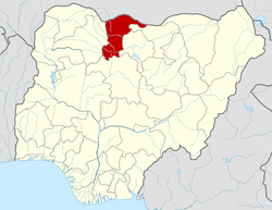 | |
This article is issued from Wikipedia - version of the 10/28/2016. The text is available under the Creative Commons Attribution/Share Alike but additional terms may apply for the media files.