Bastogne
| Bastogne Bastenaken (Dutch) Bastenach (German) | |||
|---|---|---|---|
| Municipality | |||
 | |||
| |||
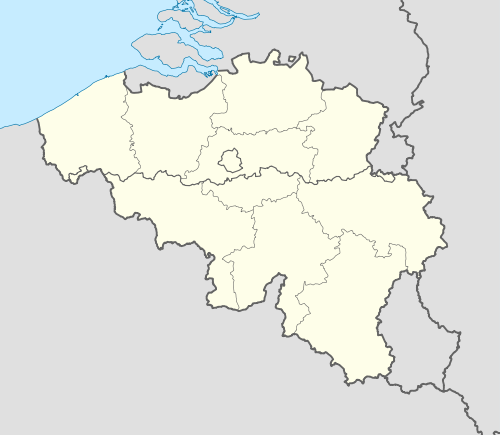 Bastogne Location in Belgium | |||
|
Location of Bastogne in Luxembourg province  | |||
| Coordinates: 50°0.25′N 05°43.2′E / 50.00417°N 5.7200°ECoordinates: 50°0.25′N 05°43.2′E / 50.00417°N 5.7200°E | |||
| Country | Belgium | ||
| Community | French Community | ||
| Region | Wallonia | ||
| Province | Luxembourg | ||
| Arrondissement | Bastogne | ||
| Government | |||
| • Mayor | Benoît Lutgen | ||
| • Governing party/ies | cdH | ||
| Area | |||
| • Total | 172.03 km2 (66.42 sq mi) | ||
| Population (1 January 2016)[1] | |||
| • Total | 15,580 | ||
| • Density | 91/km2 (230/sq mi) | ||
| Postal codes | 6600 | ||
| Area codes | 061 | ||
| Website | www.bastogne.be | ||


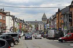
Bastogne (French pronunciation: [bas.tɔɲ], Dutch: Bastenaken, German: Bastenach, Luxembourgish: Baaschtnech) is a Walloon municipality of Belgium located in the province of Luxembourg in the Ardennes. The municipality of Bastogne includes the old communes of Longvilly, Noville, Villers-la-Bonne-Eau, and Wardin. The town is situated on a ridge in the Ardennes at an elevation of 510 metres (1,670 ft).
History
At the time of the Roman conquest the region of Bastogne was inhabited by the Treveri, a tribe of Gauls. A form of the name Bastogne was first mentioned only much later, in 634, when the local lord ceded these territories to the St Maximin's Abbey, near Trier. A century later, the Bastogne area went to the nearby Prüm Abbey. The town of Bastogne and its marketplace are again mentioned in an 887 document. By the 13th century, Henry VII, Holy Roman Emperor and count of Luxemburg, was minting coins in Bastogne. In 1332, John the Blind, his son, granted the city its charter and had it encircled by defensive walls, part of which, the current Porte de Trèves, still exists. In 1451, the lands of the county of Luxemburg were absorbed into the Duchy of Burgundy and as a result, Bastogne became part of the lands of the Spanish Crown when the Burgundian heir Charles became king of Spain in 1516.
The city’s walls were quite effective at protecting it during the troubled times that followed. The city’s economy actually flourished thanks to the renown of its agricultural and cattle fairs. The walls repelled a Dutch attack successfully in 1602. In 1688, they were dismantled by order of King Louis XIV when the town was occupied by French forces during the Nine Years War.
The 19th century and Belgium's independence were favourable to Bastogne, as its forest products and cattle fairs became better known abroad. Several railway lines were built to link it to the neighbouring towns. This all came to an end with the German occupation during World War I.
World War II
Liberated by the Allies in September 1944, Bastogne was attacked by German forces a few months later. Hitler's idea was to regain control of the Ardennes, splitting British from American forces, then advance to and reoccupy the strategic port of Antwerp and cut off the key Allied supply line. On December 16, taking advantage of cold and fog, German artillery initiated the Battle of the Bulge attacking the American divisions deployed sparsely around Bastogne. A few days later, Brigadier General McAuliffe and the 101st Airborne Division along with elements of the 10th Armored Division (United States) and the 82nd Airborne Division, arrived to counter-attack but, after heavy fighting, became encircled within the town. On December 22, German emissaries asked for the American surrender, to which the General answered tersely, “Nuts!” The next day the skies cleared, allowing Allied air forces to retaliate and to drop much needed food, medicine, and weaponry to ground forces. On December 26, the Third U.S. Army under the command of General Patton arrived and broke the deadlock. The official end of the Battle of Bastogne occurred three weeks later, when all fighting in the area ceased.
Bastogne is the terminus of the Liberty Road (France), the commemorative way that marks the path of liberating Allied forces, and of the Third Army that subsequently relieved Bastogne.
Geography
The municipality of Bastogne comprises five sections (Bastogne proper, Longvilly, Noville, Villers-la-Bonne-Eau, and Wardin) which were separate municipalities before a merger in 1977. Each contains a number of villages.
- Bastogne: Bizory, Chifontaine, Hemroulle, Isle-la-Hesse, Isle-le-Pré, Savy, Senonchamps ;
- Longvilly: Al-Hez, Arloncourt, Bourcy, Horritine, Michamps, Moinet, Oubourcy ;
- Noville: Cobru, Fagnoux, Foy, Hardigny, Luzery, Rachamps, Recogne, Vaux, Wicourt ;
- Villers-la-Bonne-Eau: Livarchamps, Losange, Lutrebois, Lutremange, Remoifosse ;
- Wardin: Benonchamps, Bras, Harzy, Mageret, Marenwez, Marvie, Mont, Neffe.
Sights

- The 101st Airborne Museum [2] includes dioramas and more about the experiences of soldiers and civilians during the siege of the city during World War II.
- The Bastogne Barracks [3] museum is free and operated by the Belgian Army. It is located in the barracks used as the headquarters of the U.S. 101st Airborne during the Siege of Bastogne. It features an extensive collection of restored tanks and military vehicles as well as a guided tour of the underground barracks and artifacts from U.S., German and British forces. The base ("caserne") is about 5 blocks from the Place de St. Pierre. The museum includes the basement office where General McAuliffe issued the famous "Nuts!" response to the German demand for surrender. Other rooms display artillery, small arms, radio and medical equipment. Belgian Army specialists guide visitors through the base.
- The Bastogne War Museum has many war artifacts and videos recreating the experience of the Battle of the Bulge for visitors.
- The Porte de Trèves, part of the defensive walls that had been erected in the 14th century by John the Blind, can still be seen.
- The Romanesque tower of St Pierre church and its baptismal fonts also date from the Middle Ages.
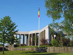
- The Mardasson Memorial, was erected near Bastogne in 1950 to honor the memory of American soldiers wounded or killed during the Battle of the Bulge.
- Monuments to Brigadier General McAuliffe, General Patton and others can be found around town.
- Recogne German war cemetery, 6 km to the North. Contains the graves of 6,807 German soldiers.
Folklore
The key character of all legends about Bastogne is the so-called piche-cacaye.[4] This is pronounced pish-cackay.
Transportation
Bastogne originally had an NMBS/SNCB railway line connecting it to Libramont and to Gouvy. Passenger trains to Gouvy stopped in 1984 [5] and in the 1990s the line to Libramont was taken out of service.[6][7] The two station buildings in Bastogne remain, but are now used for other purposes. Part of the rail line has been converted into a cycle path. However, two bus stations are now open in Bastogne, according to SNCB: Bastogne Nord and Bastonge Sud. The short line that runs is only a rural shuttle line from Bastogne Nord to Libramont stopping only at Bastogne Sud.
Sports
- Bastogne is the halfway point of the Liège–Bastogne–Liège classic bicycle race, one of the oldest and most prestigious one-day events in the professional cycling calendar, dating back to the late 19th century.
- The Circuit des Ardennes, which today refers to a bicycle race, used to refer to a 600 kilometres (370 mi) long car-racing event in the Bastogne area. The race used to attract famous enthusiasts, such as William II, German Emperor. It was relocated to Francorchamps around the time of World War I, where it now lives on as the Belgian Grand Prix.
References
- ↑ Population per municipality as of 1 January 2016 (XLS; 397 KB)
- ↑ www.101airbornemuseumbastogne.com Archived May 2, 2014, at the Wayback Machine.
- ↑ www.facebook.com/pages/Bastogne-Barracks
- ↑ "Syndicat d'Initiative de Bastogne, The Piches Cacayes". Retrieved 30 August 2009.
- ↑ Études et Documentation Ferroviaires - rail.lu
- ↑ Belgian Line News 1995
- ↑ Belgian Branch Line News 2000
External links
| Wikimedia Commons has media related to Bastogne. |
- Official city web site (French)
 |
Houffalize | Wincrange (LU-D) | | |
| Bertogne | |
Winseler (LU-D) Lac de la Haute-Sûre (LU-D) | ||
| ||||
| | ||||
| Vaux-sur-Sûre | Fauvillers | Boulaide (LU-D) |
Municipalities of Luxembourg Province | ||
|---|---|---|
| Arlon |  | |
| Bastogne | ||
| Marche-en-Famenne | ||
| Neufchâteau | ||
| Virton | ||