Barbaza, Antique
| Barbaza | |
|---|---|
| Municipality | |
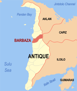 Location within Antique province | |
.svg.png) Barbaza Location within the Philippines | |
| Coordinates: 11°13′N 122°03′E / 11.22°N 122.05°ECoordinates: 11°13′N 122°03′E / 11.22°N 122.05°E | |
| Country | Philippines |
| Region | Western Visayas (Region VI) |
| Province | Antique |
| District | Lone district |
| Barangays | 39 (see Barangays) |
| Government [1] | |
| • Type | Sangguniang Bayan |
| • Mayor | Gerry Condes Necor |
| Area[2] | |
| • Total | 154.36 km2 (59.60 sq mi) |
| Population (2015 census)[3] | |
| • Total | 22,704 |
| • Density | 150/km2 (380/sq mi) |
| • Voter (2016)[4] | 14,409 |
| Time zone | PST (UTC+8) |
| ZIP code | 5706 |
| IDD : area code | +63 (0)36 |
| Income class | 4th class |
| PSGC | 060602000 |
| Website |
elgu |
Barbaza, officially the Municipality of Barbaza (Karay-a: Banwa kang Barbaza; Hiligaynon: Banwa sang Barbaza; Filipino: Bayan ng Barbaza), is a municipality in the province of Antique in the Western Visayas (Region VI) of the Philippines. The population was 22,704 at the 2015 census.[3] In the 2016 election, it had 14,409 registered voters.[4]
Major sources of income of the people are derived from agriculture, fishing, trade and commerce, employment and remittances from abroad.[5] About 94% of the total population have access to potable water. Five health centers serve 39 barangays. There is a 10-bed capacity government hospital manned by 27 health personnel.
Transportation services are generally provided by tricycles, jeepneys, vans and buses. There are also daily buses available going back and forth to Manila that pass by Barbaza via the roll-on/roll-off nautical highway.
History
Long after the discovery of the Philippines by the Spaniards led by Ferdinand Magellan on March 16, 1521, there was already an established settlement in a place presumably now Barangay Esparar. In later years however, the Moros from Palawan and Mindoro started coming to raid and plunder the inhabitants, and often abducted beautiful maidens and men to be made slaves. Because of fear, the inhabitants moved to a much safer place, in a narrow strip of land at the foot of Mount Dumangsal. The site of the new settlement up to this day is called Igtara. The population rapidly increased. When the Moros stopped coming, they decided to move down to a much wider plain. The settlement started to flourish and later a church and a town hall were built out of bamboo and cogon grass. Today, it is where Barangay Binanu-an stands. Binanu-an means “Ginbanwahan or Binanwahan”.[5]
The formation of a formal government which was headed either by a Teniente or a Captain, started at Binanu-an. The settlement in Binanu-an lasted so long until sometime in the 17th century when the inhabitants, again, found a much better place to live in because it is nearer to the sea which yields fish in abundance. They decided to transfer from Binanu-an to the seashore by the bank of the once deep river called Nalupa. The new settlement was named Nalupa Nuevo. Permanent structures like a church and a Municipal Hall were built.[5]
Unfortunately, sometime in the 18th century the settlement suffered another drawback. Dalanas River, one of the bigger rivers in Antique, used to overflow during heavy rains causing destruction to properties and lives of people living near the area. Alarmed by the situation affecting the settlement at Nalupa Nuevo, the Spanish Governor Enrique Barboza ordered to transfer the people to another site called Otngol which was at that time, part of what is now the town of Laua-an.[5]
During the transfer of the settlement from Nalupa to Otngol the Municipal Government was already run by a Capitan. The first Capitan was ('Tan) Julian Flores. He was later succeeded by ('Tan) Roman Francisco, then by Capitan Justiniano Ogatis-Barrientos. It was during his administration sometime in 1886 when he worked out for the separation of the town from the Municipality of Laua-an. The town's name was changed to Barboza in honor of Spanish Governor Enrique Barboza of Antique. The spelling was later changed to Barbaza because of the difficulty in pronouncing the former name. To this day the town is officially named the Municipality of Barbaza.[5]
Geography
Barbaza is located at 11°13′N 122°03′E / 11.22°N 122.05°E.
According to the Philippine Statistics Authority, the municipality has a land area of 154.36 square kilometres (59.60 sq mi)[2] constituting 5.66% of the 2,729.17-square-kilometre- (1,053.74 sq mi) total area of Antique.
Located at the central portion of Antique, Barbaza is 62 kilometres (39 mi) north from the provincial capital. It has a coastline of 12 kilometres (7.5 mi) along the Sulu Sea, and its highest point is Mount Nangtud with an elevation of 2,080 metres (6,820 ft), the highest mountain on Panay Island.[5]
Barangays
Barbaza is politically subdivided into 39 barangays.[6] It is composed of 22 upland and l7 lowland barangays where upland area accounts for 88.43% of the total land area.
| PSGC | Barangay | Population | ±% p.a. | ||
|---|---|---|---|---|---|
| 2015[3] | 2010[7] | ||||
| 060602002 | Baghari | 1.3% | 286 | 271 | +1.03% |
| 060602003 | Bahuyan | 3.4% | 773 | 1,025 | −5.23% |
| 060602004 | Beri | 3.9% | 889 | 704 | +4.54% |
| 060602005 | Biga-a | 1.1% | 244 | 294 | −3.49% |
| 060602006 | Binangbang | 0.9% | 201 | 211 | −0.92% |
| 060602007 | Binangbang Centro | 3.7% | 829 | 750 | +1.93% |
| 060602008 | Binanu-an | 2.0% | 451 | 396 | +2.51% |
| 060602009 | Cadiao | 0.8% | 184 | 252 | −5.81% |
| 060602010 | Calapadan | 0.6% | 125 | 122 | +0.46% |
| 060602011 | Capoyuan | 8.9% | 2,026 | 2,016 | +0.09% |
| 060602012 | Cubay | 3.5% | 792 | 777 | +0.36% |
| 060602018 | Embrangga-an | 1.5% | 341 | 282 | +3.68% |
| 060602013 | Esparar | 4.7% | 1,076 | 1,054 | +0.39% |
| 060602014 | Gua | 5.8% | 1,309 | 1,231 | +1.18% |
| 060602015 | Idao | 1.1% | 242 | 174 | +6.48% |
| 060602016 | Igpalge | 4.3% | 978 | 943 | +0.70% |
| 060602017 | Igtunarum | 0.6% | 131 | 127 | +0.59% |
| 060602019 | Integasan | 0.5% | 114 | 106 | +1.40% |
| 060602020 | Ipil | 4.4% | 1,002 | 935 | +1.33% |
| 060602021 | Jinalinan | 7.3% | 1,661 | 1,033 | +9.46% |
| 060602022 | Lanas | 0.6% | 129 | 104 | +4.19% |
| 060602023 | Langcaon (Evelio Javier) | 0.8% | 184 | 198 | −1.39% |
| 060602024 | Lisub | 3.4% | 764 | 570 | +5.74% |
| 060602025 | Lombuyan | 3.1% | 706 | 669 | +1.03% |
| 060602026 | Mablad | 2.7% | 609 | 552 | +1.89% |
| 060602027 | Magtulis | 2.1% | 477 | 403 | +3.26% |
| 060602028 | Marigne | 0.9% | 203 | 236 | −2.83% |
| 060602029 | Mayabay | 1.2% | 274 | 219 | +4.36% |
| 060602030 | Mayos | 1.0% | 219 | 210 | +0.80% |
| 060602031 | Nalusdan | 0.9% | 197 | 860 | −24.47% |
| 060602032 | Narirong | 0.9% | 215 | 202 | +1.19% |
| 060602033 | Palma | 6.2% | 1,417 | 1,392 | +0.34% |
| 060602034 | Poblacion | 6.3% | 1,428 | 1,369 | +0.81% |
| 060602035 | San Antonio | 3.0% | 677 | 657 | +0.57% |
| 060602036 | San Ramon | 0.7% | 167 | 180 | −1.42% |
| 060602037 | Soligao | 1.2% | 277 | 231 | +3.52% |
| 060602038 | Tabongtabong | 2.0% | 465 | 447 | +0.75% |
| 060602039 | Tig-Alaran | 0.5% | 121 | 118 | +0.48% |
| 060602040 | Yapo | 2.3% | 521 | 455 | +2.61% |
| Total | 22,704 | 21,775 | +0.80% | ||
Demographics
| Population census of Barbaza | |||||||||||||||||||||||||
|---|---|---|---|---|---|---|---|---|---|---|---|---|---|---|---|---|---|---|---|---|---|---|---|---|---|
|
| ||||||||||||||||||||||||
| Source: PSA[3][7][8] | |||||||||||||||||||||||||
In the 2015 census, Barbaza had a population of 22,704.[3] The population density was 150 inhabitants per square kilometre (390/sq mi).
In the 2016 election, it had 14,409 registered voters.[4]
Tourist attractions
- The Batabat and Punta Coral Reefs — features spectacular diversities of tropical fishes and distinct coral formations in vibrant colors.
- Mount Nangtud — considered the highest peak in Panay island.
- Camp Eupre Forest and Orchard Resort
- Macalbag Waterfalls — 50-ft waterfalls with unchartered caves.
- Barbaza Catholic Church — considered as the most modernly designed church in the province of Antique
Festivals
Barbaza celebrates the annual Batabat Festival, held every 3rd week of March. The feast of Saint Anthony of Padua is celebrated every 13 June.
References
- ↑ "Municipality". Quezon City, Philippines: Department of the Interior and Local Government. Retrieved 31 May 2013.
- 1 2 "Province: Antique". PSGC Interactive. Makati City, Philippines: Philippine Statistics Authority. Retrieved 30 October 2016.
- 1 2 3 4 5 "Region VI (WESTERN VISAYAS)". Census of Population (2015): Total Population by Province, City, Municipality and Barangay (Report). PSA. Retrieved 20 June 2016.
- 1 2 3 "2016 National and Local Elections Statistics". Commission on Elections. 2016.
- 1 2 3 4 5 6 "Barbaza". Official Antique Website. Retrieved 9 February 2013.
- ↑ "Municipal: Barbaza, Antique". PSA. Philippines: National Statistical Coordination Board. Retrieved 8 January 2016.
- 1 2 "Region VI (WESTERN VISAYAS)". Census of Population and Housing (2010): Total Population by Province, City, Municipality and Barangay (Report). NSO. Retrieved 29 June 2016.
- ↑ "Region VI (WESTERN VISAYAS)". Census of Population (1995, 2000 and 2007): Total Population by Province, City and Municipality (Report). NSO. Archived from the original on 24 June 2011.
 |
Tibiao | | ||
| Sulu Sea | |
Jamindan, Capiz | ||
| ||||
| | ||||
| Laua‑an |
San Jose de Buenavista (capital) | |
| Municipalities | |