Baltimore Pike
| |
|---|---|
| Route information | |
| Maintained by MDSHA and PennDOT | |
| Major junctions | |
| South end: |
|
| |
| North end: |
|
| Location | |
| States: | Maryland, Pennsylvania |
| Highway system | |
|
Auto Trails | |

The Baltimore Pike was an auto trail in the United States, connecting Baltimore, Maryland, with Philadelphia, Pennsylvania.
Today, parts of the road are signed as U.S. Route 1, U.S. Route 13, and a small portion of Pennsylvania Route 41. A section of the road within the city limits of Philadelphia and surrounding boroughs is known as Baltimore Avenue, although locals are known to call the Delaware County portion "Baltimore Pike". In further western suburbs, some sections retain the formal name "Baltimore Pike." Today, Baltimore Avenue's eastern terminus is at 38th Street in Philadelphia, where it intersects with Woodland Avenue (from Southwest Philadelphia and the borough of Darby) and funnels into University Avenue The road used to continue to Market Street until the University City area was redeveloped.
Route description
Maryland
The Baltimore Pike name is not currently used in Maryland. The routing of the Baltimore Pike in Maryland follows US 1 from Baltimore northeast to the Pennsylvania border near Rising Sun in Cecil County. The road passes through Bel Air and crosses the Susquehanna River on the Conowingo Dam.[1]
Pennsylvania
Chester County
The Baltimore Pike enters Pennsylvania from Maryland in West Nottingham Township, Chester County, with the southernmost part of the road in the state a part of US 1, which is a four-lane divided highway at this point. North of the Ridge Road intersection, US 1 becomes a freeway called the Kennett Oxford Bypass and Baltimore Pike continues northeast as a two-lane undivided road that dead ends near the US 1 freeway. The road heads through wooded areas with some homes, with an older alignment of the road known as Old Baltimore Pike looping to the west of the road. Baltimore Pike comes to the Herr's Snacks plant in the community of Nottingham, at which point the alignments of both Baltimore Pike and Old Baltimore Pike are severed, with traffic having to head west and north along Herr Drive to access PA 272. A short distance to the east along PA 272, the alignment of Baltimore Pike resumes as a two-lane undivided road and runs north-northeast past a few businesses, crossing into East Nottingham Township. The road curves northeast and passes through a mix of farmland and woodland with some residential and commercial development, running a short distance to the northwest of an East Penn Railroad line.[2][3]

Baltimore Pike turns to the north-northeast at the Barnsley Road intersection and passes through commercial areas with some residences before crossing into Oxford. At this point, the road becomes South 3rd Street and heads north past more homes and businesses. In the commercial center of Oxford, the road comes to an intersection with PA 472 and the southern terminus of PA 10, where Baltimore Pike turns east to briefly follow PA 472 on Market Street before heading northeast on Lincoln Street. The road heads through more residential and commercial areas, becoming the border between Lower Oxford Township to the northwest and Oxford to the southeast before fully entering Lower Oxford Township and the name returning to Baltimore Pike.[2][3]
Baltimore Pike continues through a mix of farmland and woodland with some homes and businesses, passing to the north of the Lincoln University campus. The road continues into Upper Oxford Township and runs through more agricultural areas with some housing developments, coming to an intersection with PA 896. Baltimore Pike heads through more rural areas of with some residential development and curves to the east, crossing the East Branch Big Elk Creek into Penn Township. At this point, the road name becomes West Baltimore Pike and it passes between residential development to the north and farmland to the south before passing north of Jennersville Regional Hospital. The road heads past a few commercial establishments, reaching an intersection with PA 796 in the community of Jennersville. Following this intersection, West Baltimore Pike heads through farmland before heading into wooded areas with residential developments and crossing into London Grove Township. The road heads near more residences and enters West Grove, becoming West Evergreen Street. Here, the road is lined with more homes and comes to an intersection with PA 841, at which point that route joins the road with the name changing to East Evergreen Street. This road curves to the northeast and PA 841 splits north onto Chatham Road. The road heads back into London Grove Township and becomes East Baltimore Pike, continuing through a mix of farms, woods, and development. East Baltimore Pike heads to the east and comes to an intersection with PA 41, at which point Baltimore Pike merges onto PA 41 and heads southeast as Gap Newport Pike.[2][3]

The road runs through areas of residential and commercial development before crossing into Avondale, where the name changes to Pennsylvania Avenue. Through this area, the road passes several homes. Baltimore Pike splits east from PA 41, heading northeast into industrial areas to the south of a quarry as a three-lane road with two eastbound lanes and one westbound lane. The road heads into New Garden Township and narrows to two lanes, passing through commercial areas to the south of New Garden Airport. Baltimore Pike continues past more homes and businesses in the community of Toughkenamon. The road heads through more rural areas with some residential and commercial development before splitting into a one-way pair that carries two-lane West Cypress Street eastbound and two-lane West Baltimore Pike westbound. The one-way pair continues through business areas with some farm fields and residential developments, entering Kennett Township. Upon crossing into Kennett Square, the name of the westbound direction becomes West State Street and the roads continue through residential areas before heading into the commercial downtown. Here, Baltimore Pike intersects PA 82 and the name of the one-way pair becomes East Cypress Street eastbound and East State Street westbound, leaving the downtown area and heading into wooded residential areas with some businesses. The roads curve to the northeast and cross back into Kennett Township, with the westbound direction becoming Millers Hill. The two one-way roads join again and become four-lane divided East Baltimore Pike, heading into commercial areas and merging into the northbound direction of US 1 at the end of the Kennett Oxford Bypass.[2][3]
At this point, US 1 continues northeast along East Baltimore Pike into East Marlborough Township and passes more businesses, widening to six lanes. The road narrows to four lanes and passes near homes and businesses before coming to an interchange that provides access to Longwood Gardens to the north of the road, at which point it crosses back into Kennett Township. A short distance later, US 1 comes to an intersection with PA 52, at which point that route heads onto East Baltimore Pike along with US 1. The road heads into wooded areas with some homes and businesses, at which point PA 52 splits to the southeast. East Baltimore Pike turns to the northeast and crosses into Pennsbury Township, where the official name becomes Baltimore Pike. The road curves to the east again and passes through more woodland with some residential and commercial development, crossing an East Penn Railroad line before heading across the Brandywine Creek.[2][3]
Delaware County

Upon crossing the Brandywine Creek, the Baltimore Pike continues into Chadds Ford Township in Delaware County and passes to the north of the Brandywine River Museum. US 1 heads into the community of Chadds Ford and intersects Creek Road in a commercial area. The road continues through wooded areas with some development, passing to the south of the Brandywine Battlefield.[2][3] Baltimore Pike curves northeast and heads into areas of businesses, intersecting US 202/US 322 in Painters Crossroads. Here, US 322 turns east to join US 1 in a concurrency along Baltimore Pike, running past more commercial establishments in Concord Township. In Concordville, US 322 splits to the southeast and US 1 continues along Baltimore Pike, heading into more wooded areas with occasional businesses.
Baltimore Pike curves to the east and enters Chester Heights, passing businesses before heading into forested areas, where it passes the corporate headquarters of Wawa Inc. The road turns northeast and crosses the Chester Creek into Middletown Township, passing under SEPTA's Media/West Chester Branch. US 1 continues into commercial areas, coming to an intersection with PA 452 in the community of Lima. Following this, Baltimore Pike continues east and passes between the closed Granite Run Mall to the north and Riddle Memorial Hospital to the south, coming to an interchange with PA 352. A short distance later, US 1 splits from Baltimore Pike by heading northeast onto the limited-access Media Bypass.[2][4]

Past this interchange, Baltimore Pike continues east as an unnumbered road, passing through woodland and crossing the Ridley Creek into Upper Providence Township. Here, the road turns northeast and enters Media, narrowing into a two-lane undivided road and becoming West Baltimore Avenue. West Baltimore Avenue curves east and heads into residential areas with some businesses. Upon reaching the commercial downtown of Media, the road intersects Jackson Street and becomes East Baltimore Avenue, passing more businesses and intersecting PA 252. A short distance past this intersection, the road heads into Nether Providence Township and becomes Baltimore Pike again, heading into wooded residential areas with some businesses. Baltimore Pike widens into a four-lane divided highway and comes to an interchange with I-476. Immediately after the interchange, the road crosses the Crum Creek into Springfield Township and passes between the Springfield Mall to the north and wooded areas of homes to the south, at which point it becomes the border between Springfield Township to the north and Swarthmore to the south. Baltimore Pike comes to an intersection with PA 320 and continues past more businesses, fully entering Springfield Township again and becoming a five-lane road with a center left-turn lane. The road curves to the east-northeast and crosses PA 420, becoming the border between Springfield Township to the north and Morton to the south past this intersection. Baltimore Pike fully enters Springfield Township and is lined with more businesses.[2][4]
At the intersection with South Bishop Avenue, the road becomes a four-lane divided highway and enters Upper Darby Township, where the name changes to Baltimore Avenue. The median turns into a center left-turn lane as the road passes more commercial establishments, becoming the border between Clifton Heights to the north and Upper Darby Township to the south. Baltimore Avenue fully enters Clifton Heights and passes through residential and commercial areas as a two-lane undivided road. After passing through the commercial downtown, the road crosses SEPTA's Route 102 trolley at the Baltimore Pike station and running past more businesses. Baltimore Avenue crosses the Darby Creek into Lansdowne and heads into wooded areas of homes, curving to the east. The road passes through the commercial downtown of Lansdowne before heading past more businesses, crossing back into Upper Darby Township. Baltimore Avenue crosses the abandoned Newtown Square Branch railroad right-of-way and becomes the border between East Lansdowne to the north and Upper Darby Township to the south, lined with more businesses. The road comes to an intersection with US 13, at which point US 13 turns east to join the road, which changes names to Baltimore Pike. Baltimore Pike fully enters Upper Darby Township again, passing between Fernwood Cemetery to the north and urban residential and commercial development to the south, becoming the border between Upper Darby Township to the north and Yeadon to the south.[2][4]
Philadelphia
Baltimore Avenue crosses Cobbs Creek into the West Philadelphia section of the city of Philadelphia. Immediately after crossing the creek, the road comes to the Angora Loop at 61st Street, which serves as the terminus of SEPTA's Route 34 trolley. At this point, the trolley tracks follow Baltimore Avenue as it continues through urban neighborhoods consisting of rowhomes along with a few businesses. The road curves to the east, passing through more urban development with the Route 34 trolley splitting from Baltimore Avenue at 40th Street, where it heads underground at the 40th Street Portal. The road heads into the University City neighborhood, becoming a four-lane road at the 39th Street intersection as it heads onto the University of Pennsylvania campus. A block later, Baltimore Avenue ends at an intersection with University Avenue, with US 13 turning north onto University Avenue.[2][4]
Streetcar service
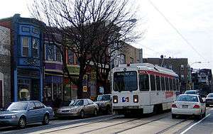
The West Philadelphia section of Baltimore Avenue has carried streetcars since 1890, when tracks were laid for horsecar service. Electric-powered trolleys began operating on the avenue on January 13, 1895.[5] Today, the avenue is served by SEPTA Route 34, which runs on Baltimore from the subway mouth at 40th Street to the Angora terminal loop at 61st Street.
History
.svg.png)
Despite its name, the road was not itself a former turnpike, but portions were, including Baltimore and Jerusalem Turnpike between Baltimore and Bel Air, Maryland. The road's easternmost part was another such section: the Chaddsford Turnpike, depicted on an 1843 map running from Mill Creek (present-day 43rd Street in West Philadelphia) to the western limits of Philadelphia County, in the direction of Chadds Ford Township in Delaware County, Pennsylvania.[6]
Its northern section was renamed Pennsylvania Route 12 in 1924.[7] Much of the route was renamed U.S. Route 1 in 1926.
Until 1928, the route crossed the Susquehanna River on the Conowingo Bridge, which was destroyed and replaced by the Conowingo Dam.
Baltimore Avenue formerly continued northward to Market Street as part of Woodland Avenue; this segment was stricken from the City street plan in the late 1950s due to redevelopment by the University of Pennsylvania and what is now Drexel University.
Major intersections
Maryland
See U.S. Route 1 in Maryland#Junction list
Pennsylvania
| County | Location | mi | km | Destinations | Notes |
|---|---|---|---|---|---|
| Chester | West Nottingham Township | Dead end | Baltimore Pike continued south on nearby US 1 to Maryland border | ||
| Road severed south of intersection, Herr Drive used to access Baltimore Pike south of PA 272 | |||||
| Oxford | South end of PA 472 overlap | ||||
| North end of PA 472 overlap | |||||
| Upper Oxford Township | |||||
| Penn Township | |||||
| West Grove | South end of PA 841 overlap | ||||
| North end of PA 841 overlap | |||||
| London Grove Township | South end of PA 41 overlap | ||||
| Avondale | North end of PA 41 overlap | ||||
| Kennett Square | |||||
| Kennett Township | Southbound exit and northbound entrance, south end of US 1 overlap | ||||
| Longwood Gardens | Interchange | ||||
| South end of PA 52 overlap | |||||
| North end of PA 52 overlap | |||||
| Delaware | Chadds Ford Township | South end of US 322 overlap | |||
| Concord Township | North end of US 322 overlap | ||||
| Middletown Township | |||||
| Interchange | |||||
| Northbound exit and southbound entrance, north end of US 1 overlap | |||||
| Media | |||||
| Nether Providence Township | I-476 exit 3 | ||||
| Springfield Township | |||||
| East Lansdowne | South end of US 13 overlap | ||||
| Philadelphia | Philadelphia | North end of US 13 overlap | |||
| 1.000 mi = 1.609 km; 1.000 km = 0.621 mi | |||||
See also
 U.S. Roads portal
 Maryland Roads portal
 Pennsylvania portal
 Philadelphia portal
References
- ↑ Google (December 31, 2011). "overview of Baltimore Pike in Maryland" (Map). Google Maps. Google. Retrieved December 31, 2011.
- 1 2 3 4 5 6 7 8 9 10 Google (December 31, 2011). "overview of Baltimore Pike in Pennsylvania" (Map). Google Maps. Google. Retrieved December 31, 2011.
- 1 2 3 4 5 6 Chester County, Pennsylvania (Map) (17th ed.). 1"=2000'. ADC Map. 2006. ISBN 0-87530-778-7.
- 1 2 3 4 Metro Philadelphia, Pennsylvania (Map) (19th ed.). 1"=2000'. ADC Map. 2006. ISBN 978-0-87530-777-0.
- ↑ Staff. "Studio 34's Eponymous Trolley, or, A Short History of Route 34". Studio 34 Yoga. Archived from the original on July 9, 2008. Retrieved May 1, 2008.
- ↑ West Philadelphis Community History Center (2009). "Chapter 2: A Streetcar Suburb in the City: West Philadelphia, 1854-1907". West Philadelphia: The Basic History. University Archives of the University of Pennsylvania. Retrieved December 28, 2011.
- ↑ Weingroff, Richard (April 7, 2011). "US 22: The William Penn Highway". Highway History. Federal Highway Administration. Retrieved December 28, 2011.
Further reading
- Faris, John Thomson (1917). Old Roads Out of Philadelphia. J.B. Lippincott. pp. 77–95. Deals with the origins and landmarks of the Baltimore Pike.