Balonne River
| Balonne | |
| River | |
 The Balonne River at St George, Queensland | |
| Name origin: Mandandanji: water or running stream.[1] | |
| Country | Australia |
|---|---|
| State | Queensland |
| Region | South West Queensland |
| Part of | Darling River, Murray-Darling basin |
| Tributaries | |
| - right | Maranoa River |
| City | St George |
| Source | Condamine River |
| - location | at Surat |
| - elevation | 274 m (899 ft) |
| Mouth |
|
| - location | near Dirranbandi |
| - elevation | 171 m (561 ft) |
| - coordinates | 28°43′27″S 148°03′6″E / 28.72417°S 148.05167°ECoordinates: 28°43′27″S 148°03′6″E / 28.72417°S 148.05167°E |
| Length | 479 km (298 mi) |
| Discharge | |
| - average | 65 m3/s (2,295 cu ft/s) |
| Reservoir | Lake Kajarabie |
 Location of Balonne River mouth where confluence is reached with the Bokhara and Narran rivers in Queensland
| |
| Wikimedia Commons: Balonne River | |
| [2] | |
The Balonne River, part of the Murray-Darling Basin system, is a short and important part of the inland river group of South West Queensland, Australia.
Course and features
The river is a continuation of the Condamine River. After flowing through Surat the river flows south south-westerly down through the E.J. Beardmore Dam (Lake Kajarabie).[2] Passing through St George it continues in the same south-west direction, until about 20 kilometres (12 mi) north of Dirranbandi, where it branches, with the western branch then being called the Culgoa River. The eastern branch continues on as the Balonne River through Dirranbandi. Shortly after flowing through Dirranbandi, the Balonne River again branches into the Bokhara River on the west (right) and the Narran River on the left (eastern) side.[3] The Bokhara river joins with the Barwon River west of Brewarrina, thus contributing to the Darling River. The Narran River flows into Narran Wetlands. The confluence of the Culgoa and Barwon Rivers forms the start of the Darling River.
The Balonne-Condamine catchment area is 136,014 square kilometres (52,515 sq mi), of which an area of 603 square kilometres (233 sq mi) is composed of riverine wetlands and 559 square kilometres (216 sq mi) is estuarine wetlands.[4]
The five longest tributaries of the Balonne River are the Condamine River, the Maranoa River, Dogwood Creek, Yuleba Creek and Tartulla Creek. St St George, the river is crossed by the Andrew Nixon Bridge which carries the Balonne Highway.[5]
Water storage
E.J. Beardmore Dam was formed by the construction of a weir in 1972 at the junction of the Maranoa and Balonne Rivers.[6] When the dam is full the water backs up for 70 kilometres (43 mi) along the Balonne. Downstream from Beardmore Dam is the Jack Taylor Weir, which was built in 1953.[6] On the Balonne tributary, Dogwood Creek there is another weir, the Gill Weir, which can hold 1,050 megalitres (230×106 imp gal; 280×106 US gal).
History
Major Thomas Mitchell crossed the Balonne River on St George's Day, 23 April 1846. Mitchell named the river after the Mandandanji word for water or running stream, balun or balonn or balonne.[1]
Gallery
-
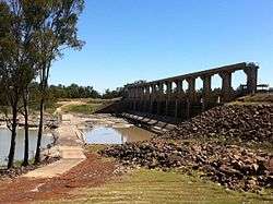
E.J. Beardmore Dam viewed from the downstream side.
-

Irrigation channel for cotton fed from E.J. Beardmore Dam.
-

Siphon irrigation of cotton near St George, Queensland.
-

Jack Taylor Weir viewed from downstream side at St George, Queensland.
See also
References
- 1 2 "Balonne River River (entry 1434)". Queensland Place Names. Queensland Government. Retrieved 23 June 2015.
- 1 2 "Map of Balonne River, QLD". Bonzle Digital Atlas of Australia. Retrieved 31 January 2009.
- ↑ "Chisholm, Alec H.". The Australian Encyclopaedia. 1. Sydney: Halstead Press. 1963. p. 406. Balonne River.
- ↑ "Balonne-Condamine drainage basin drainage basin". WetlandInfo. Queensland Government. Retrieved 23 June 2015.
- ↑ "Andrew Nixon Bridge". Balonne Shire Council. Retrieved 8 February 2011.
- 1 2 Harrison, Rod; Ernie James; Chris Sully; Bill Classon; Joy Eckermann (2008). Queensland Dams. Bayswater, Victoria: Australian Fishing Network. p. 155. ISBN 978-1-86513-134-4.
Rivers of Queensland | |||||||||||||||||||||||||
|---|---|---|---|---|---|---|---|---|---|---|---|---|---|---|---|---|---|---|---|---|---|---|---|---|---|
| |||||||||||||||||||||||||
| |||||||||||||||||||||||||
| |||||||||||||||||||||||||
| |||||||||||||||||||||||||
| |||||||||||||||||||||||||
| |||||||||||||||||||||||||
River systems and rivers of the Darling River catchments, Australia | |
|---|---|
| Darling River | |
| Warrego | |
| Macintyre | |
| Barwon / Macquarie | |
| |