Balatonalmádi
| Balatonalmádi | ||
|---|---|---|
|
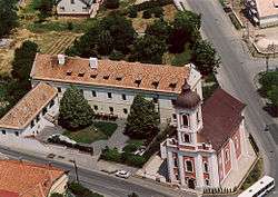
Aerial view | ||
| ||
 Balatonalmádi Location of Balatonalmádi | ||
| Coordinates: 47°01′28″N 18°00′40″E / 47.02433°N 18.01124°E | ||
| Country |
| |
| County | Veszprém | |
| Area | ||
| • Total | 49.89 km2 (19.26 sq mi) | |
| Population (2004) | ||
| • Total | 8,716 | |
| • Density | 174.7/km2 (452/sq mi) | |
| Time zone | CET (UTC+1) | |
| • Summer (DST) | CEST (UTC+2) | |
| Postal code | 8220 | |
| Area code(s) | 88 | |

Balatonalmádi, a town of 8,500 inhabitants, is a popular resort town near the northeast corner of Lake Balaton, in Hungary.
History
The town developed from three previously separated villages, which were united by combining Balatonalmádi and Káptalanfüred in 1952, and Balatonalmádi and Vörösberény in 1971. At its beginnings, the settlement was called Almádi, and later Almádi-puszta, and belonged to the vineyard located on the current city centre. The vineyards were destroyed in the end of the 1800s by phylloxera.
There is a unique Calvinist church. Around the church there is a special stonewall. Not far from here there is a Catholic church, which was built between 1977–79. Inside there are frescoes. On the other side there is a building from the 18th century. Under this building there is a huge cellar where a wine house and wine museum will be opened as well.
The village of Vörösberény existed already during the Hungarian conquest. King Stephen I donated it to Greek nuns inhabiting Veszprém Valley, according to the first charter in Greek containing the settlement's name. The first summer season started officially in 1874. Almadi summer festival starting from June to September every weekend with special programmes. The growth of Balatonalmádi was quickened by the opening of the railway in 1909.
External links
Coordinates: 47°02′N 18°01′E / 47.033°N 18.017°E