Balabac Island
 | |
.svg.png) Balabac Island Location within the Philippines | |
| Geography | |
|---|---|
| Location | Balabac Strait |
| Coordinates | 7°56′31″N 117°0′29″E / 7.94194°N 117.00806°ECoordinates: 7°56′31″N 117°0′29″E / 7.94194°N 117.00806°E |
| Archipelago | Balabac Group of Islands |
| Adjacent bodies of water | |
| Length | 31 km (19.3 mi) |
| Width | 17 km (10.6 mi) |
| Highest elevation | 525 m (1,722 ft) |
| Administration | |
|
Philippines | |
| Region | MIMAROPA |
| Province | Palawan |
| Municipality | Balabac |
Balabac Island is the southern-most island of the Palawan province in the Philippines, only about 50 kilometres (31 mi) north from Sabah, Malaysia, across the Balabac Strait.
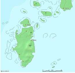
Administratively, the island forms the main part of Balabac Municipality and is divided into 14 barangays (the other 6 barangays of the municipality are on other nearby islands):
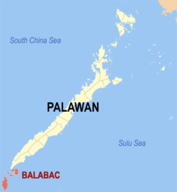 Location within the province of Palawan |
|
|
Balabac Island is home to various endemic species. It is the home of birds like the grey imperial pigeon (Ducula pickeringii), Philippine cockatoo (Cacatua haematuropygia), blue-headed racket-tail (Prioniturus platenae), and the Palawan hornbill (Anthracoceros marchei). The Philippine mouse-deer, a subspecies of the greater mouse-deer (Tragulus napu) can only be found in this island.
The Molbogs, a Muslim ethnolinguistic group, is concentrated in this island. Their livelihood includes farming, fishing and barter trading with the nearby Mapun and Sabah market centres.