Badghis Province
| Badghis بادغیس | |
|---|---|
| Province of Afghanistan | |
|
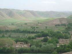
A village in Badghis | |
 Location within Afghanistan | |
 Districts prior to 2005 realignment | |
| Coordinates: 35°0′N 63°45′E / 35.000°N 63.750°ECoordinates: 35°0′N 63°45′E / 35.000°N 63.750°E | |
| Country |
|
| Provincial seat | Qala i Naw |
| Districts | |
| Government | |
| • Governor | Jamaluddin Ishaq |
| Area | |
| • Total | 20,590.6 km2 (7,950.1 sq mi) |
| • Water | 0 km2 (0 sq mi) |
| Population (2013)[1] | |
| • Total | 499,393 |
| • Density | 20.9/km2 (54/sq mi) |
| Demographics | |
| • Ethnic groups | Tajiks, Pashtuns, Uzbeks, Turkmen |
| • Languages | Dari Persian, Pashto, Turkmen |
| ISO 3166 code | AF-BDG |
Bādghīs (Pashto/Persian: بادغیس) is one of the thirty-four provinces of Afghanistan, located in the northwest of the country next to Turkmenistan. The name means "home of the winds" in Persian and Pashto languages, referring to the steppe winds that blow into the province from the north and northwest. Badghis is irrigated by the Murghab . Its northern border extends to the edge of the desert of Sarakhs. Badghis includes the Chul formations through which the Turkmen-Afghan boundary runs.[2] The province was carved out of portions of Herat Province and Meymaneh Province in 1964 and has a total area of 20,591 km2.[3] It is counted as one of the most underdeveloped of the country's 34 provinces. Qala i Naw, a small town halfway between Maimana and Herat, serves as the provincial center.
History
The province was one of the last captured by the Taliban in their military offensive before the American invasion in 2001. The province was quickly retaken by Northern Alliance forces as the United States initiated hostilities.
The province was flooded by governors which was in favor of Hamed Karzai and recently Ghani Ahmadzai after Taliban removed from power. These governors did not make a positive change. Especially governor Nasiri, who was moved to Zabul facilitated the raising of Taliban.
Politics
The current Governor of the province is Jamaluddin Ishaq.
At the province was a Provincial Reconstruction Team, which was led by Spain.
Economy
Agriculture is the main source of people's income and the existence of Murghab, river makes the available land suitable for cultivation. The province faced severe drought during the late 1990s and early 2000s, causing tens of thousands of residents to flee to refugee camps outside Herat. The situation has since improved.[4] Badghis is the leading province in Afghanistan in pistachio production. It is also one of the carpet-making capitals of the country.
Transportation
Badghis Province suffers from a lack of adequate transportation. A single airport exists at the provincial seat--Qala i Naw Airport (QAQN), which is capable of handling light aircraft.[5] Work on a 233 km section of the Afghan ring road has started in 2012.[6] This will connect Herat to Mazar-i Sharif and open up Badghis to the rest of Afghanistan. This section goes from Laman in Herat Province to Qaisar in Faryab Province, through Qala-e-Now, Muqur, Bala Murghab and Ghormach. Badghis is part of National Ring road, but because of Pashtuns supremacy and their power in the government, they made it immposible to built it. There are three main reason why do not want the connection of ring road. 1. The southern provinces with Pashtun majority will get less benefit from Herat-Kabul highway. 2. The ring road will connect North to West of the country which are non-Pashtun majority and mostly it will benefit non-Pashtun. 3. It will pave the way for breaking the old school pashtun theory to keep Afghanistan border safe by pashtuns. Pashtuns will lose the irrigated lands in Bala Murghab by flood of farmers from Faryab and Herat.
Healthcare
The percentage of households with clean drinking water fell from 11.6% in 2005 to 1% in 2011.[7] The percentage of births attended to by a skilled birth attendant increased from 15% in 2005 to 17% in 2011.[7]
Education: According to information of education department, there are 457 schools with 75 high and the rests are primary and secondary schools. As many as 120,000 students with 35% of them are female students. There is one vocational high school of agriculture and one midwife training Institute in the province as well.
Geography
Badghis Province is located in the isolated hills of northwestern Afghanistan and shares its borders with Herat, Ghor, and Faryab provinces as well as Turkmenistan. The province is dominated by the Murghab River in the north and the Hari-Rud River in the south.
Districts
- Ab Kamari
- Ghormach District official administrated by Faryab
- Jawand District
- Muqur District, Badghis
- Murghab District
- Qadis District
- Qala i Naw District
Demography
Like in the rest of Afghanistan, no exact population numbers are available. The Afghan Ministry of Rural Rehabilitation & Development (MRRD) along with UNHCR and Central Statistics Office (CSO) of Afghanistan estimates the population of the province to be around 499,393. According to the same sources, Tajiks make up around 56% of the total population, followed by 40% Pashtuns and 4% Uzbeks, Turkmens, Balochs and other minorities.[8]According to AIMS and NPS, the population of Badghis consists of 62% Tajik, 28% Pashtun, 5% Uzbek, 3% Turkmen, and 2% Baloch.[9] It is counted as one of the most underdeveloped of the country's 34 provinces. Qala i Naw, a small town half-way between Sheberghan and Herat serves as the provincial center.
References
- ↑ "Afghanistan Ministry of Rural Rehabilitation and Development: Badghis Provincial Profile" (PDF). Mrrd.gov.af. Retrieved 2016-09-25.
- ↑
 Chisholm, Hugh, ed. (1911). "Badghis". Encyclopædia Britannica. 3 (11th ed.). Cambridge University Press.
 - ↑ Bosworth, C. E.; Balland, D. "BAÚD¨GÚÈS". In Yarshater, Ehsan. Encyclopædia Iranica. United States: Columbia University. Archived from the original on 2009-01-02. Retrieved 2007-12-19.
- ↑
- ↑ Qala-i-Naw Airport at the Islamic Republic of Afghanistan Ministry of Transport and Civil Aviation
- ↑ "Archived copy". Archived from the original on 2013-09-30. Retrieved 2013-06-10.
- 1 2 "Archived copy". Archived from the original on 2014-05-31. Retrieved 2014-05-30.
- ↑ http://www.mrrd.gov.af/nabdp/Provincial%20Profiles/Badghis%20PDP%20Provincial%20profile.pdf
- ↑ http://www.nps.edu/Programs/CCS/Badghis/Badghis_Executive_Summary.pdf
External links
- Map of Badghis Province (PDF)
- Badghis Province Overview - Slides (University of Montana)
- Afghanistan Information Management Service
 |
Mary Province, |
Faryab Province | | |
| |
||||
| ||||
| | ||||
| Herat Province | Ghor Province |