Bad River Band of the Lake Superior Tribe of Chippewa Indians
|
Historic photo of Ojibwe at Bad River | |
| Total population | |
|---|---|
| 7,000 (2000)[1] | |
| Regions with significant populations | |
|
| |
| Languages | |
| English, Ojibwe | |
| Religion | |
| Catholicism, Methodism, Midewiwin | |
| Related ethnic groups | |
| other Ojibwe people, Odawa and Potwatomi |

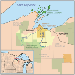
The Bad River Lapointe Band of the Lake Superior Tribe of Chippewa Indians are a federally recognized tribe of Ojibwe people. The Bad River Reservation is located on the south shore of Lake Superior and has a land area of 156,000 acres (244 sq mi; 630 km2) in northern Wisconsin straddling Ashland and Iron counties. The tribe has approximately 7,000 members, of whom about 1,800 lived on the reservation during the 2000 census.[1]
Most people live in one of four communities: Odanah, Diaperville (also called Old Odanah),[2] Birch Hill, or Frank's Field/Aspen Estates.[3] Odanah, the administrative and cultural center, is located five miles (8.0 km) east of the town of Ashland on U.S. Highway 2. New Odanah is also located on the reservation. Over 90% of the reservation is undeveloped land.
History
According to Anishinaabe prophecy, Gichi Manidoo, the Great Spirit, told the Anishinaabe people to move west from the Atlantic coast until they found the "food that grows on water."[4] After a series of stops and divisions, the branch of Anishinaabe known as the Lake Superior Chippewa found wild rice near the Chequamegon Bay on the south shore of Lake Superior, at the site of the present-day Bad River Lapointe Reservation. They made their final stopping place at nearby Madeline Island.
After the 17th century, Anishinaabe people settled throughout northern Wisconsin into lands formerly disputed with the Dakota Sioux and the Meskwaki. Those that remained near the trading post of La Pointe on Madeline Island were known collectively as the La Pointe Band; they engaged in the fur trade with neighboring French-Canadian settlers. They also pursued other seasonal occupations such as berry-picking, harvesting maple sugar, fishing, ricing, hunting, and gathering nuts, roots and medicinal plants.
After a disastrous attempt at removing the Lake Superior Bands in the 19th century, which resulted in the Sandy Lake Tragedy, the U.S. government agreed to set up permanent reservations in Wisconsin. At this point, the La Pointe band split: members who had converted to Roman Catholicism were led by Kechewaishke (Chief Buffalo) and took a reservation at Red Cliff. Those who maintained traditional Midewiwin beliefs settled at Bad River. The two bands, however, maintain close relations to this day.
The reservation land was set aside for the Bad River Lapointe Band in the Treaty of La Pointe, made with the United States and signed on Madeline Island on September 30, 1854. The treaty land included almost 2,000 acres (3.1 sq mi; 8.1 km2) on Madeline Island, which is considered the center of the Ojibwe Nation. The band is one of six federally recognized tribes in present-day Wisconsin.
During the late 19th century, the Franciscan Sisters of Perpetual Adoration set up St. Mary's School in Odanah, an Indian boarding school. Students came from a variety of tribes to learn English and western topics, as well as Christianity. During this period, timber companies on the reservation leased land for lumbering, but they cheated the tribe and destroyed much of the land by overlogging. During the Allotment period, the tribe leased almost half its land base, which originally covered all the area of modern-day Ashland, Wisconsin.
Revival of sovereignty
As Lake Superior Ojibwe, the Bad River Lapointe Band retains its rights to hunt, fish, gather wild rice, and medicinal plants over the ceded territory of northern Wisconsin, Michigan, and Minnesota. The tribe pressed these claims throughout the 20th century. Tribal members from Bad River and the other Lake Superior bands resumed their traditional practice of spear fishing, resulting in the Wisconsin Walleye War with recreational and sports fishermen.
In 1996, a group of Ojibwe activists known as the Anishinaabe Ogitchida blocked a railroad shipment of sulfuric acid from crossing the reservation; it was destined for a copper mine in Michigan. The protestors complained the acid posed an environmental danger to reservation lands and the Lake Superior watershed. The national attention brought by the protests forced the Environmental Protection Agency to stop the use of acid in the mine.[5]
Sixteen thousand acres (25 sq mi; 65 km2) of the reservation are high-quality wetlands due the Kakagon River and Bad River sloughs, registered by the United States government under the Ramsar Convention on Wetlands of International Importance. The wetlands are ideal for the cultivation of wild rice, the historical crop of the Ojibwe. The sloughs constitute the only remaining extensive coastal wild rice marsh in the Great Lakes region. Due to its habitat and proximity to Madeline Island, Bad River is of major importance to the Ojibwe Nation. People from all over Ojibwe Country come for the annual August Celebration of the manoomin, or wild rice harvest.
The headquarters of the Great Lakes Indian Fish & Wildlife Commission (GLIFWC) is on the Bad River Reservation. The tribe also owns and operates a fish hatchery, which stocks local rivers and lakes with 15 million walleye annually.
The Bad River Band Of Lapoint Ojibwe own and operate a casino, as well as the Moccasin Trail gas station and grocery store complex. The Tribe also runs a clinic, local transit, tribal school, daycare, and Head Start, as well as a police and volunteer fire department for its people. It has several community facilities: a tribal fire hall and youth center in the Birch Hill community, and a utility garage in the Franks Field community.
Topography
Bad River Reservation is nearly entirely covered by a forest and swamps. In Anishinaabemowin, they called the Anishinaabe people who lived around swamps Omashkiigowag ("Swampy people"), from mashkiig meaning "swamp". The people also go by Mashkigonaabeg, which means "Swampy-men:, where the suffix -naabe is "male" or "man" in the Anishinaabe language.
On the northern border of the Reservation, the elevation tends to be between 600 and 700 feet (180 and 210 m) above sea level. Southwards the elevation increases to between 700 and 1,100 feet (210 and 340 m) above sea level. Scattered across the reservation are many small lakes.
Climate

Bad River Reservation has extreme climate conditions. Winters are long and cold, while summers are short and warm. The climate is largely affected by Lake Superior. Low temperatures during the cold winter months tend to average slightly above 0 °F (−18 °C). High temperatures during the cold winter months average above 20 °F (−7 °C). Average low temperatures during the summer months are near 50 and 55 °F (10 and 13 °C). Average high temperatures during the summer months are between 74 and 80 °F (23 and 27 °C). Precipitation is significant as a result of the extensive forest and Lake Superior. Average yearly precipitation is around 30 inches (760 mm).
Notes
- 1 2 "Bad River Reservation, Wisconsin". United States Census Bureau.
- ↑ Watindato, Elizabeth Arbuckle (March 12, 2007). "Tribal Members: A Surprising Diverse Group" (PDF). Robert M. La Follette School of Public Affairs, University of Wisconsin–Madison. p. 6.
- ↑ "History of Bad River Band of the Lake Superior of Chippewa Indians".
- ↑ Tigerman 2006, p. 95
- ↑ Grossman, Zoltan (October 1996). "Chippewa Block Acid Shipments: The Anishinaabe Ogitchida Group, Protectors of the People, Fight Against Transport of 550 Mil Gal of Sulphuric Acid for a Copper Mining Recovery Project". The Progressive. Retrieved July 31, 2010 – via CBS Interactive Business Network.
References
- Loew, Patty (2001). Indian Nations of Wisconsin: Histories of Endurance and Renewal. Madison: Wisconsin Historical Society Press.
- Tigerman, Kathleen (2006). Wisconsin Indian Literature: Anthology of Native Voices. Madison: University of Wisconsin Press. ISBN 978-0-299-22064-8.
External links
| Wikimedia Commons has media related to Bad River Indian Reservation. |
- Bad River Band of the Lake Superior Tribe of Chippewa Indians, official website
- Great Lakes Intertribal Council description
- A Brief Bad River History/Description
- Current news in Bad River
- Oklevueha Seminole
Coordinates: 46°31′52″N 90°40′31″W / 46.53111°N 90.67528°W
Municipalities and communities of Ashland County, Wisconsin, United States | ||
|---|---|---|
| Cities | 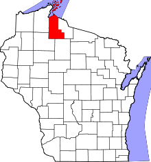 | |
| Village | ||
| Towns | ||
| CDPs | ||
| Unincorporated communities | ||
| Indian reservation | ||
| Footnotes | ‡This populated place also has portions in an adjacent county or counties | |
Municipalities and communities of Iron County, Wisconsin, United States | ||
|---|---|---|
| Cities | 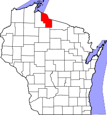 | |
| Towns | ||
| CDPs | ||
| Unincorporated communities | ||
| Indian reservations | ||
| Footnotes | ‡This populated place also has portions in an adjacent county or counties | |