Babb Creek
| Babb Creek | |
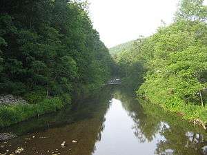 Babb Creek from the Pennsylvania Route 287 bridge in the village of Morris | |
| Country | United States |
|---|---|
| State | Pennsylvania |
| County | Tioga County |
| Source | east of Wellsboro |
| - location | Tioga State Forest, Tioga County |
| - elevation | 1,902 ft (580 m) [1] |
| - coordinates | 41°44′39″N 77°13′16″W / 41.74417°N 77.22111°W [2] |
| Mouth | Pine Creek |
| - location | Blackwell, Tioga County |
| - elevation | 846 ft (258 m) [2] |
| - coordinates | 41°33′13″N 77°22′50″W / 41.55361°N 77.38056°WCoordinates: 41°33′13″N 77°22′50″W / 41.55361°N 77.38056°W [2] |
| Length | 21.7 mi (34.9 km) |
 Location of the mouth of Babb Creek in Pennsylvania
| |
Babb Creek is a 21.7-mile-long (34.9 km)[3] tributary of Pine Creek in Pennsylvania in the United States.[4]
The tributary Stony Fork Creek joins Babb Creek just upstream of the community of Blackwell, 3.5 miles (5.6 km) upstream of Pine Creek.[4]
Babb Creek joins Pine Creek at the community of Blackwell in Tioga County.[4]
See also
References
- ↑ Source elevation derived from Google Earth search using GNIS source coordinates.
- 1 2 3 "Babb Creek". Geographic Names Information System (GNIS). United States Geological Survey. August 2, 1979. Retrieved September 3, 2012.
- ↑ "The National Map Viewer: National Hydrography Dataset". United States Geological Survey. Archived from the original on April 5, 2012. Retrieved August 8, 2011.
- 1 2 3 Gertler, Edward. Keystone Canoeing, Seneca Press, 2004. ISBN 0-9749692-0-6


This article is issued from Wikipedia - version of the 10/23/2016. The text is available under the Creative Commons Attribution/Share Alike but additional terms may apply for the media files.