BMT Nassau Street Line
| BMT Nassau Street Line | |
|---|---|
|
Train services that use the BMT Nassau Street Line through downtown have been colored brown since 1979. One station is also served by the M train, which is now part of the IND Sixth Avenue Line. | |
| Overview | |
| Type | Rapid transit |
| System | New York City Subway |
| Termini |
Essex Street Broad Street |
| Stations | 6 |
| Daily ridership | 126,833[1] |
| Operation | |
| Opened | 1908-1931 |
| Owner | City of New York |
| Operator(s) | New York City Transit Authority |
| Character | Underground |
| Technical | |
| Number of tracks | 2-4 |
| Track gauge | 4 ft 8 1⁄2 in (1,435 mm) |
| Electrification | 600V DC third rail |
BMT Nassau Street Line |
|---|
Legend |
The BMT Nassau Street Line is a rapid transit line of the B Division of the New York City Subway system in Manhattan. It is a continuation of the BMT Jamaica Line in Brooklyn after crossing the Williamsburg Bridge; it continues to a junction with the BMT Broadway Line just before the Montague Street Tunnel after which the line reenters Brooklyn (no revenue service south of Broad Street since June 25, 2010).
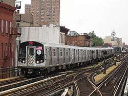
The line is served at all times by the J train. The Z provides supplemental rush hour service, operating in the peak direction.
While the line is officially recognized as the Nassau Street Line,[2] it only serves one station on Nassau Street: Fulton Street.
The M service has historically served the Nassau Street Line. Since June 28, 2010, the M has been rerouted via the Chrystie Street Connection to run on the IND Sixth Avenue Line, as a replacement for the V, which was discontinued on June 25, 2010 due to financial shortfalls. However, the M does continue to serve one Nassau Street Line station: the Essex Street station.
Service
The following services use part or all of the Nassau Street Line. The trunk line's bullets are colored terra cotta brown:
| Time period | Section of line | |||
|---|---|---|---|---|
| Rush hours | Middays, evenings, weekends |
Late nights | ||
| local |
| |||
| local | no service | |||
| local in peak direction |
no service |
| ||
History
After the original IRT opened, the city began planning new lines. Two of these were extensions of that system, to Downtown Brooklyn and Van Cortlandt Park, but the other two - the Centre Street Loop Subway (or Brooklyn Loop Subway) and Fourth Avenue Subway (in Brooklyn) - were separate lines for which construction had not progressed as far. The Centre Street Loop, approved on January 25, 1907 as a four-track line (earlier proposed as two tracks),[3] was to connect the Brooklyn Bridge, Manhattan Bridge, and Williamsburg Bridge via Centre Street, Canal Street, and Delancey Street. An extension south from the Brooklyn Bridge under William Street to Wall Street was also part of the plan, as were several loops towards the Hudson River and a loop connecting the bridges through Brooklyn. Construction contracts for the main line in Manhattan were awarded in early 1907, despite no determination of the operator once completed. The line was assigned to a proposed Tri-borough system in early 1908 and to the Brooklyn Rapid Transit Company (BRT) in the Dual Contracts, adopted on March 4, 1913.[4][5]

The BRT began operating through a short piece of subway, coming off the Williamsburg Bridge under Delancey Street to Essex Street, on September 16, 1908.[6] The Centre Street Loop was opened to Chambers Street (at the Brooklyn Bridge) on August 4, 1913,[7] with temporary operation at first on the two west tracks.[8] The south tracks on the Manhattan Bridge, also running into Chambers Street, were placed in service on June 22, 1915.
On March 19, 1913, the Brooklyn Rapid Transit Company (later reorganized as the BMT) and the city signed Contract 4, which provided for the construction of certain lines. Most of the construction was completed by 1924, but the Nassau Street Line was not yet completed. The BMT chairman Gerhard Dahl was persistent at requesting that the city build the line, but Mayor John Hylan refused to act during his final two years as mayor. Once James Walker succeeded him as mayor, contracts for the project were awarded, with the portion north of Liberty Street awarded to Marcus Contracting Company and the portion south of Liberty Street awarded to Moranti and Raymond.[9]
Work was projected to be completed in 39 months, and in March 1929, sixty percent of the work had been finished. Nassau Street is only 34 feet wide, and the subway floor was only 20 feet below building foundations. As a result, 89 building had to be underpinned to ensure that they would stay on their foundations. Construction had to be done 20 feet below the active IRT Lexington Avenue Line. An area filled with quicksand with water, that used to belong to a spring, was found between John Street and Broad Street. Construction was done at night so as to not disturb workers in the Financial District. The whole cost of the construction of the line was $10,072,000 for the 0.9 mile extension, or $2,068 a foot, which was three times the normal cost of construction at the time.[9]
The Nassau Street Loop opened at 3 P.M. on May 29, 1931, when Mayor Jimmy Walker took the controls of a train of D-Type Triplex Cars from the Chambers Street station to Broad Street.[10] The line was extended two stops from its previous terminus at Chambers Street through the Fulton Street and Broad Street stations and to a connection to the Montague Street Tunnel, which allowed trains to run to Brooklyn.[11] The line's completion allowed subway trains to operate via the Culver Line, whose operation used to consist of elevated trains that ran to Ninth Avenue, where transfers were made to West End subway trains. The new line provided an additional ten percent capacity more than the existing service through DeKalb Avenue. Service on the Jamaica Line was extended to operate to this station.[12]
The completion of the line ended a $30,000,000 suit brought against the city by the BMT for not building the line before January 1, 1917.[10] This station was named Broad Street even though it is on Wall Street, to distinguish it from the two other stations of that name on the Lexington Avenue Line and Seventh Avenue Line.[13]
Because of the curve of Nassau Street at Fulton Street, that station had to be constructed on two levels; the upper level carried southbound trains with entrances on the east side of Nassau Street, and the lower level carried northbound trains with entrances on the west side of Nassau Street.[13][14]
Plans for the Chambers Street area changed several times during construction, always including a never-completed connection to the Brooklyn Bridge tracks. By 1910, only the west two tracks were to rise onto the bridge, and the east two were to continue south to the Montague Street Tunnel. As actually built for the 1931 opening south of Chambers Street, the two outer tracks ran south to the tunnel, while the two inner tracks continued several blocks in a lower level stub tunnel to allow trains to reverse direction.[15]
On September 20, 2004, northbound trains began running on the second track from the west (serving the former southbound platform), and the former northbound platforms at Canal Street and Bowery were closed off. The second track from the east was removed.[16][17]
On June 14, 2015, weekend J service was extended back to Broad Street; this was proposed in July 2014 to improve weekend service between Lower Manhattan and Brooklyn.[18][19][20][19] Between 1990 and 2015, when weekend service terminated at Canal, between September 30, 1990[21] and January 1994,[22] or Chambers Streets, from January 1994 to June 2015, Broad Street and the J/Z platforms at Fulton Street were two of the four New York City Subway stations that lacked full-time service (the remaining two being the platforms for the IRT 42nd Street Shuttle).
Station listing
| Station service legend | |
|---|---|
| |
Stops all times |
| |
Stops all times except late nights |
| |
Stops late nights only |
| |
Stops weekdays only |
| |
Stops rush hours only |
| |
Stops rush hours in the peak direction only |
| Time period details | |
| Neighborhood (approximate) |
Station | Services | Opened | Transfers and notes | |
|---|---|---|---|---|---|
| Begins as the BMT Jamaica Line comes off the Williamsburg Bridge (J | |||||
| Lower East Side | Essex Street | J |
September 16, 1908[6] | IND Sixth Avenue Line (F | |
| Split to Chrystie Street Connection (M | |||||
| Bowery | J |
August 4, 1913[7] | |||
| Chinatown | Canal Street | J |
August 4, 1913[7] | BMT Broadway Line (N IRT Lexington Avenue Line (4 | |
| Former Connection to Manhattan Bridge south tracks | |||||
| Civic Center | Chambers Street | J |
August 4, 1913[7] | IRT Lexington Avenue Line (4 | |
| Financial District | Fulton Street | J |
May 29, 1931[14] | IRT Broadway – Seventh Avenue Line (2 IRT Lexington Avenue Line (4 IND Eighth Avenue Line (A Connection to BMT Broadway Line (N | |
| Broad Street | J |
May 29, 1931[14] | |||
| Terminus of all service | |||||
| Line merges with the BMT Broadway Line (N | |||||
References
- ↑ MTA. "Average weekday subway ridership". Retrieved 2 April 2014.
- ↑ Marrero, Robert (2015-09-13). "469 Stations, 846 Miles" (PDF). B24 Blog, via Dropbox. Retrieved 2015-10-09.
- ↑ New York Times, Subway Loop Approved, January 26, 1907, page 16
- ↑ James Blaine Walker, Fifty Years of Rapid Transit, 1864-1917, published 1918, pp. 203-239
- ↑ Engineering News, A New Subway Line for New York City, Volume 63, No. 10, March 10, 1910
- 1 2 New York Times, Mayor Runs a Train Over New Bridge, September 17, 1908, page 16
- 1 2 3 4 New York Times, Passenger Killed on Loop's First Day, August 5, 1913, page 2
- ↑ Public Service Commission For the First District, New Subways For New York: The Dual System of Rapid Transit, Chapter 1
- 1 2 Linder, Bernard (February 2016). "Contract 4 Subway Controversy". The Bulletin. Electric Railroaders' Association. 59 (2). Retrieved July 28, 2016.
- 1 2 Cunningham, Joseph; DeHart, Leonard O. (1993-01-01). A History of the New York City Subway System. J. Schmidt, R. Giglio, and K. Lang.
- ↑ Derrick, Peter (2002-04-01). Tunneling to the Future: The Story of the Great Subway Expansion That Saved New York. NYU Press. ISBN 9780814719541.
- ↑ "NASSAU ST. SERVICE OUTLINED BY B.M.T.; Loop to Be Used for Direct Connection From Brooklyn andJamaica to Manhattan.TO START 14TH ST. LINE New Schedules Filed With TransitBoard Provide Full SubwayRide on Culver Line.". The New York Times. 1931-05-21. ISSN 0362-4331. Retrieved 2016-07-28.
- 1 2 "NASSAU ST. SUBWAY TO OPEN ON MAY 30; Its Construction an Engineering Feat Because Many Buildings Had to Be Underpinned. COST $10,072,000 TO BUILD It Will Link B.M.T.'s Centre Street Loop With Tunnel Under East River. 14TH ST. EXTENSION READY Connection With Eighth Avenue Line Will Go Into Operation on the Same Day.". The New York Times. 1931-05-10. ISSN 0362-4331. Retrieved 2016-07-28.
- 1 2 3 Photo, Times Wide World (1931-05-30). "MAYOR DRIVES TRAIN IN NEW SUBWAY LINK; THE MAYOR BECOMES A MOTORMAN.". The New York Times. ISSN 0362-4331. Retrieved 2016-07-28.
- ↑ Joseph Brennan, Abandoned Stations: Chambers St closed platforms, accessed March 22, 2007
- ↑ Joseph Brennan, Abandoned Stations: Canal St platform, accessed April 18, 2007
- ↑ Peter Dougherty, Tracks of the New York City Subway, Centennial Commemorative Edition 3.7a, ©2004, page 65
- ↑ "mta.info - 2014 - 2017 MTA Financial Plan". mta.info.
- 1 2 "MTA - news - MTA's Proposed 2015 Budget Includes Systemwide Service Enhancements". mta.info.
- ↑ "J train service upgrade part of MTA's new financial plan".
- ↑ "Service Changes September 30, 1990" (PDF). subwaynut.com. New York City Transit Authority. September 30, 1990. Retrieved May 1, 2016.
- ↑ Glickman, Todd (October 6, 1998). "Archive of NYC Subway Maps". mit.edu. Retrieved July 28, 2016.
| Services |
|      | ||||||
|---|---|---|---|---|---|---|---|---|
| Stations | ||||||||
| Divisions | ||||||||
| Other lists | ||||||||
| Expansion | ||||||||
| History | ||||||||
| Infrastructure | ||||||||
| Arts and culture | ||||||||
| Miscellaneous | ||||||||
| Other rapid transit in NYC | ||||||||