Bình Chánh District
| Binh Chanh District Huyện Bình Chánh | |
|---|---|
| Suburban district | |
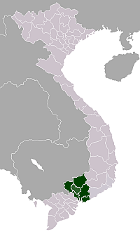
 Position in the metropolitan area of HCMC | |
 Binh Chanh District Location in Vietnam | |
| Coordinates: 10°45′01″N 106°30′45″E / 10.75028°N 106.51250°ECoordinates: 10°45′01″N 106°30′45″E / 10.75028°N 106.51250°E | |
| Country |
|
| Centrally governed city | Ho Chi Minh City |
| Seat | Tân Túc Town |
| Town, communes | 1 thị trấn, 15 xã |
| Area | |
| • Total | 253 km2 (98 sq mi) |
| Population | |
| • Total | 447,291 |
| • Density | 1,800/km2 (4,600/sq mi) |
| Demographics | |
| • Main ethnic groups | predominantly Kinh |
| Time zone | ICT (UTC+07) |
| Website | binhchanh.hochiminhcity.gov.vn |
Bình Chánh is a suburban district of Ho Chi Minh City in Vietnam. In 2003, An Lạc township and Bình Hưng Hòa, Bình Trị Đông and Tân Tạo wards were separated to establish 10 wards for Bình Tân district.
Bình Chánh district consists of a district capital, Tân Túc Town, and 15 wards: An Phú Tây, Bình Chánh, Bình Hưng, Bình Lợi, Đa Phước, Hưng Long, Lê Minh Xuân, Phạm Văn Hai, Phong Phú, Quy Đức, Tân Kiên, Tân Nhựt, Tân Quý Tây, Vĩnh Lộc A and Vĩnh Lộc B
As of 2010, the district had a population of 447,291. It covers an area of 253 km².[1]
Traffic
Bình Chánh district is one of the gateway of Ho Chi Minh City, connect to other provinces. The district also has Ho Chi Minh City - Trung Luong Expressway, make driving to Tiền Giang and the rest of Mekong Delta faster.
References
- ↑ "HCMC's Population and population density in 2010 by district". HCMC Office of Statistics. Retrieved Feb 4, 2014.
External links
- UBND Huyện Bình Chánh Thành phố Hồ Chí Minh—official website