Avena Township, Fayette County, Illinois
| Avena Township | |
|---|---|
| Township | |
|
Greenhouses on U.S. Route 40, west of St. Elmo | |
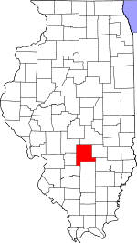
 Location in Fayette County | |
 Fayette County's location in Illinois | |
| Coordinates: 39°02′35″N 88°51′44″W / 39.04306°N 88.86222°WCoordinates: 39°02′35″N 88°51′44″W / 39.04306°N 88.86222°W | |
| Country | United States |
| State | Illinois |
| County | Fayette |
| Established | November 9, 1859 |
| Area | |
| • Total | 36.47 sq mi (94.5 km2) |
| • Land | 36.32 sq mi (94.1 km2) |
| • Water | 0.15 sq mi (0.4 km2) 0.41% |
| Elevation | 597 ft (182 m) |
| Population (2010) | |
| • Total | 2,010 |
| • Density | 55.3/sq mi (21.4/km2) |
| Time zone | CST (UTC-6) |
| • Summer (DST) | CDT (UTC-5) |
| ZIP codes | 62418, 62458 |
| GNIS feature ID | 0428624 |

Avena Township is one of twenty townships in Fayette County, Illinois, USA. As of the 2010 census, its population was 2,010 and it contained 855 housing units.[1]
Geography
According to the 2010 census, the township has a total area of 36.47 square miles (94.5 km2), of which 36.32 square miles (94.1 km2) (or 99.59%) is land and 0.15 square miles (0.39 km2) (or 0.41%) is water.[1]
Cities, towns, villages
Extinct towns
- Howards Point
- Pruett
Cemeteries
The township contains these five cemeteries: Crums Chapel, Guy, Maplewood, Seidner, Saint Bonaventure and Yolton.
Major highways
School districts
- Brownstown Community Unit School District 201
- St Elmo Community Unit School District 202
Political districts
- Illinois's 19th congressional district
- State House District 102
- State Senate District 51
References
- "Avena Township, Fayette County, Illinois". Geographic Names Information System. United States Geological Survey. Retrieved 2010-01-16.
- United States Census Bureau 2007 TIGER/Line Shapefiles
- United States National Atlas
- 1 2 "Population, Housing Units, Area, and Density: 2010 - County -- County Subdivision and Place -- 2010 Census Summary File 1". United States Census. Retrieved 2013-05-28.
External links
 |
Loudon Township | | ||
| Sefton Township | |
Mound Township, Effingham County | ||
| ||||
| | ||||
| Otego Township | Wheatland Township | West Township, Effingham County |
Municipalities and communities of Fayette County, Illinois, United States | ||
|---|---|---|
| Cities | ||
| Villages | ||
| Townships | ||
| Unincorporated communities | ||
This article is issued from Wikipedia - version of the 10/22/2016. The text is available under the Creative Commons Attribution/Share Alike but additional terms may apply for the media files.