Atmautluak Airport
| Atmautluak Airport | |||||||||||
|---|---|---|---|---|---|---|---|---|---|---|---|
 | |||||||||||
| IATA: ATT – ICAO: none – FAA LID: 4A2 | |||||||||||
| Summary | |||||||||||
| Airport type | Public | ||||||||||
| Owner | Alaska DOT&PF - Central Region | ||||||||||
| Serves | Atmautluak, Alaska | ||||||||||
| Elevation AMSL | 17 ft / 5 m | ||||||||||
| Coordinates | 60°52′00″N 162°16′23″W / 60.86667°N 162.27306°W | ||||||||||
| Runways | |||||||||||
| |||||||||||
| Statistics | |||||||||||
| |||||||||||
Atmautluak Airport (IATA: ATT[3], FAA LID: 4A2) is a state-owned public-use airport located in Atmautluak, in the Bethel Census Area of the U.S. state of Alaska.[1]
As per Federal Aviation Administration records, this airport had 2,613 passenger boardings (enplanements) in calendar year 2007, an increase of 29% from the 2,018 enplanements in 2006.[2]
Facilities
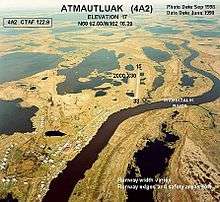
Atmautluak Airport has one runway designated 15/33 with a 3,000 by 75 ft (914 x 23 m) gravel surface.[1] The runway was previously 2,000 by 30 ft[4] until it was expanded by the state.[5]
Airlines and destinations
| Airlines | Destinations |
|---|---|
| Ravn Alaska | Bethel[6] |
References
- 1 2 3 FAA Airport Master Record for 4A2 (Form 5010 PDF), effective 2008-07-31.
- 1 2 Preliminary CY 2007 Passenger Boarding and All-Cargo Data. Federal Aviation Administration. 2008-07-17.
- ↑ ATT / 4A2 - Atmautluak, Alaska. Great Circle Mapper. Retrieved 2008-09-17.
- ↑ Airport diagram (GIF). Federal Aviation Administration, Alaskan Region. 2003-10-30.
- ↑ Atmautluak Airport Reconstruction (PDF). State of Alaska Capital Project Summary. Department of Transportation and Public Facilities. 2001-12-13.
- ↑ Era Alaska Timetable Archived March 3, 2011, at the Wayback Machine. (PDF). Retrieved April 17, 2011.
External links
- FAA Alaska airport diagram (GIF)
- Resources for this airport:
- FAA airport information for 4A2
- AirNav airport information for 4A2
- ASN accident history for ATT
- FlightAware airport information and live flight tracker
- SkyVector aeronautical chart for 4A2
This article is issued from Wikipedia - version of the 11/14/2016. The text is available under the Creative Commons Attribution/Share Alike but additional terms may apply for the media files.