Ashfield, Massachusetts
| Ashfield, Massachusetts | ||
|---|---|---|
| Town | ||
|
Ashfield Town Hall (center), with the fire station on the left. | ||
| ||
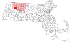 Location in Franklin County in Massachusetts | ||
| Coordinates: 42°31′35″N 72°47′20″W / 42.52639°N 72.78889°WCoordinates: 42°31′35″N 72°47′20″W / 42.52639°N 72.78889°W | ||
| Country | United States | |
| State | Massachusetts | |
| County | Franklin | |
| Settled | 1743 | |
| Incorporated | 1765 | |
| Government | ||
| • Type | Open town meeting | |
| Area | ||
| • Total | 40.3 sq mi (104.3 km2) | |
| • Land | 40.0 sq mi (103.6 km2) | |
| • Water | 0.3 sq mi (0.7 km2) | |
| Elevation | 1,244 ft (379 m) | |
| Population (2010) | ||
| • Total | 1,737 | |
| • Density | 43/sq mi (17/km2) | |
| Time zone | Eastern (UTC-5) | |
| • Summer (DST) | Eastern (UTC-4) | |
| ZIP code | 01330 | |
| Area code(s) | 413 Exchange: 628 | |
| FIPS code | 25-02095 | |
| GNIS feature ID | 0619377 | |
| Website |
www | |


Ashfield is a town in Franklin County, Massachusetts, United States. The population was 1,737 at the 2010 census.[1] It is part of the Springfield, Massachusetts Metropolitan Statistical Area.
History
Ashfield was first settled in 1743 and was officially incorporated in 1765. The town was originally called "Huntstown" for Captain Ephraim Hunt, who died in King William's War, and who had inherited the land as payment for his services. The first permanent settlement was in 1745, by Richard Ellis, an Irish immigrant from the town of Easton. The town was renamed upon reincorporation, although there is debate over its namesake; it is either for the ash trees in the area, or because Governor Bernard had friends in Ashfield, England. The town had a small peppermint industry in the nineteenth century, but for the most part the town has had a mostly agrarian economy, with some tourism around Ashfield Pond.
Ashfield is the birthplace of prominent director Cecil B. DeMille (whose parents were vacationing in the town at the time), Alvan Clark, nineteenth century astronomer and telescope maker, and William S. Clark, member of the Massachusetts Senate and third president of Massachusetts Agricultural College (now UMass Amherst).[2]
Geography
According to the United States Census Bureau, the town has a total area of 40.3 square miles (104.3 km2), of which 40.0 square miles (103.6 km2) is land and 0.27 square miles (0.7 km2), or 0.62%, is water.[3] Ashfield is located in the southwest corner of Franklin County, along the Hampshire County line. Ashfield is bordered by Buckland to the north, Conway to the east, Goshen to the south, Cummington to the southwest, Plainfield to the west, and Hawley to the northwest. Ashfield is 15 miles (24 km) west-southwest of Greenfield, 35 miles (56 km) north-northwest of Springfield, and 105 miles (169 km) west-northwest of Boston.
Ashfield lies in the eastern foothills of The Berkshires, with several high hills, including Ridge Hill, in the northern portion of town. The town is fed by several rivers and brooks, including the South River, the "western" Swift River (the "eastern" river flows out of the Quabbin Reservoir in central Massachusetts) and several prominent brooks, most of which feed into either the Deerfield River or the Connecticut River. Near the center of town, Ashfield Lake feeds into the South River, and is a recreational site. In the southwest portion of town, a small portion of the Poland Brook Wildlife Management Area crosses into town, as does a portion of the Daughters of the American Revolution State Forest.
The town is at the junction of the north-south Route 112 and the east-west Route 116, which are combined for 1.4 miles (2.3 km) south of Ashfield Lake. The town is located approximately 12 miles (19 km) west of Interstate 91, the nearest interstate to the town. The nearest bus service is in Greenfield, with the nearest small air service being Turners Falls just east of there. The nearest Amtrak service is in either Greenfield, Northampton, or Pittsfield, and the nearest international air service is at Bradley International Airport in Windsor Locks, Connecticut.
Demographics
| Historical population | ||
|---|---|---|
| Year | Pop. | ±% |
| 1840 | 1,579 | — |
| 1850 | 1,394 | −11.7% |
| 1860 | 1,302 | −6.6% |
| 1870 | 1,180 | −9.4% |
| 1880 | 1,066 | −9.7% |
| 1890 | 1,025 | −3.8% |
| 1900 | 955 | −6.8% |
| 1910 | 959 | +0.4% |
| 1920 | 869 | −9.4% |
| 1930 | 860 | −1.0% |
| 1940 | 872 | +1.4% |
| 1950 | 977 | +12.0% |
| 1960 | 1,131 | +15.8% |
| 1970 | 1,274 | +12.6% |
| 1980 | 1,458 | +14.4% |
| 1990 | 1,715 | +17.6% |
| 2000 | 1,800 | +5.0% |
| 2010 | 1,737 | −3.5% |
Source: United States Census records and Population Estimates Program data.[4][5][6][7][8][9][10][11][12][13] | ||
As of the census[14] of 2000, there were 1,800 people, 741 households, and 500 families residing in the town. By population, Ashfield ranked thirteenth of the twenty-six towns in Franklin County, and 296th out of the 351 cities and towns in Massachusetts. The population density was 44.7 people per square mile (17.2/km²), which ranked seventeenth in the county and 314th in the Commonwealth. There were 821 housing units at an average density of 20.4 per square mile (7.9/km²). The racial makeup of the town was 97.33% White, 0.61% African American, 0.11% Native American, 0.33% Asian, 0.06% from other races, and 1.56% from two or more races. Hispanic or Latino of any race were 0.44% of the population.
There were 741 households out of which 31.8% had children under the age of 18 living with them, 55.6% were married couples living together, 9.2% had a female householder with no husband present, and 32.4% were non-families. 24.0% of all households were made up of individuals and 8.2% had someone living alone who was 65 years of age or older. The average household size was 2.43 and the average family size was 2.90.
In the town the population was spread out with 23.8% under the age of 18, 4.9% from 18 to 24, 26.5% from 25 to 44, 33.2% from 45 to 64, and 11.6% who were 65 years of age or older. The median age was 42 years. For every 100 females there were 96.3 males. For every 100 females age 18 and over, there were 88.7 males.
The median income for a household in the town was $52,875, and the median income for a family was $56,739. Males had a median income of $38,818 versus $31,146 for females. The per capita income for the town was $26,483. About 5.2% of families and 7.6% of the population were below the poverty line, including 14.4% of those under age 18 and 5.1% of those age 65 or over.
Government
Ashfield employs the open town meeting form of government, and is led by a board of selectmen and a town administrator. All of the town's services are located in the town center, including the town hall, police and fire departments, as well as the Belding Memorial Library and the town's post office. The nearest hospital, Franklin Medical Center, is located in Greenfield, as are most of the nearest state offices.
On the state level, Ashfield is represented in the Massachusetts House of Representatives as part of the Second Berkshire district, represented by Paul Mark, which covers central Berkshire County, as well as portions of Hampshire and Franklin Counties. In the Massachusetts Senate, the town is part of the Berkshire, Hampshire and Franklin district, represented by Ben Downing, which includes all of Berkshire County as well as western portions of Franklin and Hampshire Counties.[15] The town is patrolled by the Second Barracks of Troop "B" of the Massachusetts State Police, headquartered in Shelburne Falls.[16]
On the national level, Ashfield is represented in the United States House of Representatives as part of Massachusetts's 1st congressional district, and has been represented by Richard Neal of Springfield since January 3, 2013. Massachusetts is currently represented in the United States Senate by Ed Markey, and Elizabeth Warren.
Education
Ashfield is a member of the Mohawk Trail Regional School District, which covers nine towns.[17] Sanderson Academy serves the town's students from pre-kindergarten through sixth grade, and also serves neighboring Plainfield. All district students from grades 7-12 attend Mohawk Trail Regional High School in neighboring Buckland. There are several private, religious and charter schools located in the Greenfield area, with the most prominent being Deerfield Academy in Deerfield, Northfield Mount Hermon School in Gill, and the Academy at Charlemont in Charlemont.
The nearest community college, Greenfield Community College, is located in Greenfield. The nearest state college is Massachusetts College of Liberal Arts in North Adams, and the nearest state university is the University of Massachusetts Amherst. The nearest private colleges, including members of the Five Colleges and Seven Sisters, are located southeast in the Northampton area.
Notable people
- Ray Lamontagne
- Cecil B DeMille
- John Q. Adams, former Wisconsin State Senator and Wisconsin State Assemblyman[18]
See also
References
- ↑ "Profile of General Population and Housing Characteristics: 2010 Demographic Profile Data (DP-1): Ashfield town, Franklin County, Massachusetts". U.S. Census Bureau, American Factfinder. Archived from the original on September 11, 2013. Retrieved August 22, 2012.
- ↑ Town of Ashfield - Franklin County Chamber of Commerce
- ↑ "Geographic Identifiers: 2010 Demographic Profile Data (DP-1): Ashfield town, Franklin County, Massachusetts". U.S. Census Bureau, American Factfinder. Archived from the original on September 11, 2013. Retrieved August 22, 2012.
- ↑ "TOTAL POPULATION (P1), 2010 Census Summary File 1". American FactFinder, All County Subdivisions within Massachusetts. United States Census Bureau. 2010.
- ↑ "Massachusetts by Place and County Subdivision - GCT-T1. Population Estimates". United States Census Bureau. Retrieved July 12, 2011.
- ↑ "1990 Census of Population, General Population Characteristics: Massachusetts" (PDF). US Census Bureau. December 1990. Table 76: General Characteristics of Persons, Households, and Families: 1990. 1990 CP-1-23. Retrieved July 12, 2011.
- ↑ "1980 Census of the Population, Number of Inhabitants: Massachusetts" (PDF). US Census Bureau. December 1981. Table 4. Populations of County Subdivisions: 1960 to 1980. PC80-1-A23. Retrieved July 12, 2011.
- ↑ "1950 Census of Population" (PDF). Bureau of the Census. 1952. Section 6, Pages 21-10 and 21-11, Massachusetts Table 6. Population of Counties by Minor Civil Divisions: 1930 to 1950. Retrieved July 12, 2011.
- ↑ "1920 Census of Population" (PDF). Bureau of the Census. Number of Inhabitants, by Counties and Minor Civil Divisions. Pages 21-5 through 21-7. Massachusetts Table 2. Population of Counties by Minor Civil Divisions: 1920, 1910, and 1920. Retrieved July 12, 2011.
- ↑ "1890 Census of the Population" (PDF). Department of the Interior, Census Office. Pages 179 through 182. Massachusetts Table 5. Population of States and Territories by Minor Civil Divisions: 1880 and 1890. Retrieved July 12, 2011.
- ↑ "1870 Census of the Population" (PDF). Department of the Interior, Census Office. 1872. Pages 217 through 220. Table IX. Population of Minor Civil Divisions, &c. Massachusetts. Retrieved July 12, 2011.
- ↑ "1860 Census" (PDF). Department of the Interior, Census Office. 1864. Pages 220 through 226. State of Massachusetts Table No. 3. Populations of Cities, Towns, &c. Retrieved July 12, 2011.
- ↑ "1850 Census" (PDF). Department of the Interior, Census Office. 1854. Pages 338 through 393. Populations of Cities, Towns, &c. Retrieved July 12, 2011.
- ↑ "American FactFinder". United States Census Bureau. Archived from the original on 2013-09-11. Retrieved 2008-01-31.
- ↑ List of Massachusetts Legislators by City and Town
- ↑ Station B-2, SP Shelburne Falls
- ↑ http://mohawkschools.org/co.php
- ↑ Jones, James Edwin (1914). A history of Columbia County, Wisconsin: a narrative account of its historical progress, its people, and its principal interests, Volume 2. Lewis Publishing Co. p. 583.
External links
| Wikimedia Commons has media related to Ashfield, Massachusetts. |
- Town of Ashfield official website
- The Ashfield News, local newspaper
- Mohawk School System
Municipalities and communities of Franklin County, Massachusetts, United States | ||
|---|---|---|
| City |  | |
| Towns | ||
| CDPs | ||
| Other villages | ||
| Former inhabited places | ||