Ashby, Massachusetts
| Ashby, Massachusetts | ||
|---|---|---|
| Town | ||
| ||
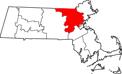
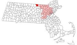 Location in Middlesex County in Massachusetts | ||
| Coordinates: 42°40′40″N 71°49′15″W / 42.67778°N 71.82083°WCoordinates: 42°40′40″N 71°49′15″W / 42.67778°N 71.82083°W | ||
| Country | United States | |
| State | Massachusetts | |
| County | Middlesex | |
| Settled | 1676 | |
| Incorporated | 1767 | |
| Government | ||
| • Type | Open town meeting | |
| Area | ||
| • Total | 24.2 sq mi (62.6 km2) | |
| • Land | 23.8 sq mi (61.6 km2) | |
| • Water | 0.4 sq mi (1.0 km2) | |
| Elevation | 904 ft (276 m) | |
| Population (2010) | ||
| • Total | 3,074 | |
| • Density | 130/sq mi (49/km2) | |
| Time zone | Eastern (UTC-5) | |
| • Summer (DST) | Eastern (UTC-4) | |
| ZIP code | 01431 | |
| Area code(s) | 351 / 978 | |
| FIPS code | 25-01955 | |
| GNIS feature ID | 0618214 | |
| Website | www.ci.ashby.ma.us | |

Ashby is a town in Middlesex County, Massachusetts, United States. The population was 3,074 at the 2010 census.[1]
Geography
According to the United States Census Bureau, the town has a total area of 24.2 square miles (63 km2), of which 23.8 square miles (62 km2) is land and 0.4 square miles (1.0 km2) (1.53%) is water.
Ashby is bordered by New Ipswich, New Hampshire and Mason, New Hampshire to the north, Townsend to the east, Lunenburg to the southeast, Fitchburg to the south, and Ashburnham to the west.
Public transportation
Public transportation for Ashby is largely supplied by the Montachusett Regional Transit Authority (MART). MART[2] operates fixed-route bus services, shuttle services, as well as paratransit services within the Montachusett Region.
Demographics
| Historical population | ||
|---|---|---|
| Year | Pop. | ±% |
| 1850 | 1,208 | — |
| 1860 | 1,091 | −9.7% |
| 1870 | 994 | −8.9% |
| 1880 | 914 | −8.0% |
| 1890 | 825 | −9.7% |
| 1900 | 876 | +6.2% |
| 1910 | 885 | +1.0% |
| 1920 | 834 | −5.8% |
| 1930 | 982 | +17.7% |
| 1940 | 1,026 | +4.5% |
| 1950 | 1,464 | +42.7% |
| 1960 | 1,883 | +28.6% |
| 1970 | 2,274 | +20.8% |
| 1980 | 2,311 | +1.6% |
| 1990 | 2,717 | +17.6% |
| 2000 | 2,845 | +4.7% |
| 2010 | 3,074 | +8.0% |
| * = population estimate. Source: United States Census records and Population Estimates Program data.[3][4][5][6][7][8][9][10][11][12] | ||
At the 2010 census,[13] there were 3,074 people, 1,105 households and 862 families residing in the town. The population density was 129.2 per square mile (49.9/km2). There were 1,191 housing units at an average density of 50.0 per square mile (19.3/km2). The racial makeup of the town was 97.1% White, 0.4% African American, 0.2% Native American, 0.3% Asian, 0.4% from other races, and 1.6% from two or more races. Hispanic or Latino of any race were 1.9% of the population.
There were 1,060 households of which 34.1% had children under the age of 18 living with them, 66.5% were married couples living together, 0.9% had a male householder with no wife present, 6.7% had a female householder with no husband present, and 25.8% were non-families. 12.8% of all households were made up of individuals and 5.9% had someone living alone who was 65 years of age or older. The average household size was 2.86 and the average family size was 3.20.
Of the 3,074 people in the population, 24.5% were under the age of 18, 8.0% were 15 to 19 years of age, 4.6% were 20 to 24 years of age, 22.7% were 25 to 44 years of age, 35.6% were 45 to 64 years of age, and 10.5% were 65 years and over. The median age was 42.6 years. For every 100 females there was 101.0 males. For every 100 females 18 years and over there were 102.0 males.
_-_Ashby%2C_Massachusetts.JPG)
The median household income was $82,614, and the median family income was $84,655. The median income of individuals working full-time was $62,355 for males versus $44,511 for females. The per capita income for the town was $32,434. About 0.9% of families and 4.0% of the population were below the poverty line, including 0.0% of those under age 18 and 5.0% of those age 65 or over.
History
Ashby was first settled in 1676 and was officially incorporated in 1767. The town separated from Ashburnham and took the old town's nickname.

Ashby Free Public Library
The library is a public library, founded in 1874 "largely through the efforts of Rev. George S. Shaw."[14] In the 1890s it was "kept in a private house" open to the public Tuesday and Friday afternoons.[15] Around 1890 the Ashby library had "1,584 volumes, with which its inhabitants have a pleasant and profitable acquaintance."[16]
In 1901 businessman and Civil War veteran Edwin Chapman donated a new building, which opened in 1902.[17]
See also
References
- ↑ "Profile of General Population and Housing Characteristics: 2010 Demographic Profile Data (DP-1): Ashby town, Middlesex County, Massachusetts". U.S. Census Bureau, American Factfinder. Archived from the original on September 11, 2013. Retrieved April 5, 2012.
- ↑ http://mrta.us
- ↑ "TOTAL POPULATION (P1), 2010 Census Summary File 1". American FactFinder, All County Subdivisions within Massachusetts. United States Census Bureau. 2010.
- ↑ "Massachusetts by Place and County Subdivision - GCT-T1. Population Estimates". United States Census Bureau. Retrieved July 12, 2011.
- ↑ "1990 Census of Population, General Population Characteristics: Massachusetts" (PDF). US Census Bureau. December 1990. Table 76: General Characteristics of Persons, Households, and Families: 1990. 1990 CP-1-23. Retrieved July 12, 2011.
- ↑ "1980 Census of the Population, Number of Inhabitants: Massachusetts" (PDF). US Census Bureau. December 1981. Table 4. Populations of County Subdivisions: 1960 to 1980. PC80-1-A23. Retrieved July 12, 2011.
- ↑ "1950 Census of Population" (PDF). Bureau of the Census. 1952. Section 6, Pages 21-10 and 21-11, Massachusetts Table 6. Population of Counties by Minor Civil Divisions: 1930 to 1950. Retrieved July 12, 2011.
- ↑ "1920 Census of Population" (PDF). Bureau of the Census. Number of Inhabitants, by Counties and Minor Civil Divisions. Pages 21-5 through 21-7. Massachusetts Table 2. Population of Counties by Minor Civil Divisions: 1920, 1910, and 1920. Retrieved July 12, 2011.
- ↑ "1890 Census of the Population" (PDF). Department of the Interior, Census Office. Pages 179 through 182. Massachusetts Table 5. Population of States and Territories by Minor Civil Divisions: 1880 and 1890. Retrieved July 12, 2011.
- ↑ "1870 Census of the Population" (PDF). Department of the Interior, Census Office. 1872. Pages 217 through 220. Table IX. Population of Minor Civil Divisions, &c. Massachusetts. Retrieved July 12, 2011.
- ↑ "1860 Census" (PDF). Department of the Interior, Census Office. 1864. Pages 220 through 226. State of Massachusetts Table No. 3. Populations of Cities, Towns, &c. Retrieved July 12, 2011.
- ↑ "1850 Census" (PDF). Department of the Interior, Census Office. 1854. Pages 338 through 393. Populations of Cities, Towns, &c. Retrieved July 12, 2011.
- ↑ "American FactFinder". United States Census Bureau. Retrieved June 13, 2013.
- ↑ http://mblc.state.ma.us/libraries/directory/index.php Retrieved 05-18-2010
- ↑ Report of the Free Public Library Commission of Massachusetts. 1891.
- ↑ Hurd, ed. History of Middlesex County, Massachusetts. J. W. Lewis & co., 1890.
- ↑ Report of the Free Public Library Commission of Massachusetts. 1903.
External links
| Wikimedia Commons has media related to Ashby, Massachusetts. |
- Town of Ashby official website
- http://ashbylibrary.org/
- Google news archive. Articles about the library.
- http://www.flickr.com/photos/36063118@N08/3326747647/
- http://web.me.com/jstewartroberts/Massachusetts/Ashby_MA.html