Armissan
| Armissan | ||
|---|---|---|
|
Church of Saint Etienne in Armissan | ||
| ||
 Armissan | ||
|
Location within Occitanie region  Armissan | ||
| Coordinates: 43°11′17″N 3°05′50″E / 43.1881°N 3.0972°ECoordinates: 43°11′17″N 3°05′50″E / 43.1881°N 3.0972°E | ||
| Country | France | |
| Region | Occitanie | |
| Department | Aude | |
| Arrondissement | Narbonne | |
| Canton | Coursan | |
| Intercommunality | Le Grand Narbonne | |
| Government | ||
| • Mayor (2008–2020) | Gérard Kerfyser | |
| Area1 | 12.51 km2 (4.83 sq mi) | |
| Population (2009)2 | 1,547 | |
| • Density | 120/km2 (320/sq mi) | |
| Time zone | CET (UTC+1) | |
| • Summer (DST) | CEST (UTC+2) | |
| INSEE/Postal code | 11014 / 11110 | |
| Elevation | 3–195 m (9.8–639.8 ft) | |
|
1 French Land Register data, which excludes lakes, ponds, glaciers > 1 km² (0.386 sq mi or 247 acres) and river estuaries. 2 Population without double counting: residents of multiple communes (e.g., students and military personnel) only counted once. | ||

Armissan (Occitan: Armissan) is a French commune in the Aude department in the Occitanie region of southern France.
The inhabitants of the commune are known as Armissannais or Armissannaises [1]
Geography
Armissan is part of the urban area of Narbonne and is located just 2 km east of the city immediately south of Vinassan and inside the Regional Natural Park of Narbonne. Access to the commune is by road D68 from Narbonne passing through the town and continuing south-east to join the D168 to Narbonne-Plage at the southern border of the commune. The D168 from Narbonne to Narbonne-Plage also passes through the south of the commune. There is also the D31 going south from Vinasson through the west of the commune to join the D32. The A9 autoroute passes through the west of the commune but has no exit - the nearest exit is Exit 37 at Narbonne. The commune has large forests in the south-west and in the north with the rest of the commune farmland.[2]
The Ruisseau Mayral with many tributaries flows through the village west to join a network of canals west of the A9.
Neighbouring communes and villages[2]
 |
Vinassan | Fleury | | |
| Narbonne | |
|||
| ||||
| | ||||
| Narbonne-Plage |
History
Heraldry
.svg.png) |
Blazon: Ermine, in fesse fusilly Or and Azure. |
Administration
List of Successive Mayors[3]
| From | To | Name | Party | Position |
|---|---|---|---|---|
| 2001 | 2020 | Gérard Kerfyser |
(Not all data is known)
Demography
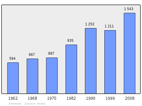
In 2009 the commune had 1,547 inhabitants. The evolution of the number of inhabitants is known from the population censuses conducted in the commune since 1793. From the 21st century, a census of communes with fewer than 10,000 inhabitants is held every five years, unlike larger towns that have a sample survey every year.[Note 1]
| 1793 | 1800 | 1806 | 1821 | 1831 | 1836 | 1841 | 1846 | 1851 |
|---|---|---|---|---|---|---|---|---|
| 281 | 472 | 418 | 443 | 439 | 493 | 511 | 520 | 526 |
| 1856 | 1861 | 1866 | 1872 | 1876 | 1881 | 1886 | 1891 | 1896 |
|---|---|---|---|---|---|---|---|---|
| 545 | 582 | 685 | 633 | 725 | 905 | 921 | 917 | 873 |
| 1901 | 1906 | 1911 | 1921 | 1926 | 1931 | 1936 | 1946 | 1954 |
|---|---|---|---|---|---|---|---|---|
| 905 | 859 | 796 | 804 | 846 | 851 | 738 | 576 | 609 |
| 1962 | 1968 | 1975 | 1982 | 1990 | 1999 | 2006 | 2009 | - |
|---|---|---|---|---|---|---|---|---|
| 636 | 713 | 687 | 935 | 1,252 | 1,211 | - | 1,547 | - |
Sources : Ldh/EHESS/Cassini until 1962, INSEE database from 1968 (population without double counting and municipal population from 2006)
Economy
The commune is part of the Languedoc AOC.
Sites and monuments

- The Remains of the Church of Saint Peter (Middle Ages)
 are registered as an historical monument.[4]
 - The Chateau of Armissan
- The War Memorial (20th century)
 is registered as an historical object.[5]
The Church of Saint-Etienne contains many items that are registered as historical objects:
- The Tombstone of René de Chefdebien (1615)[6]
- Statues (18th-19th century)[7]
- An Altar Painting: Saints Pierre and Etienne (17th century)[8]
- A box for holy oils (1684)[9]
- A Ciborium (1654)[10]
- A Ciborium (17th century)[11]
- A Bronze Bell (1732)[12]
- A Sacristy Washbasin (15th century)[13]
- A Statue/Reliquary: Saint Roch (18th century)[14]
- 4 Altar Candlesticks and a Cross (17th century)[15]
- 6 Altar Candlesticks and a Cross (17th century)[16]
See also
External links
- Armissan official website (French)
- Armissan on Lion1906
- Armissan on Google Maps
- Armissan on Géoportail, National Geographic Institute (IGN) website (French)
- Armißan on the 1750 Cassini Map
- Armissan on the INSEE website (French)
- INSEE (French)
Notes and references
Notes
- ↑ At the beginning of the 21st century, the methods of identification have been modified by Law No. 2002-276 of 27 February 2002, the so-called "law of local democracy" and in particular Title V "census operations" allows, after a transitional period running from 2004 to 2008, the annual publication of the legal population of the different French administrative districts. For communes with a population greater than 10,000 inhabitants, a sample survey is conducted annually, the entire territory of these communes is taken into account at the end of the period of five years. The first "legal population" after 1999 under this new law came into force on 1 January 2009 and was based on the census of 2006.
References
- ↑ Inhabitants of Aude (French)
- 1 2 Google Maps
- ↑ List of Mayors of France (French)
- ↑ Ministry of Culture, Mérimée PA00102538 Remains of the Church of Saint Peter (French)

- ↑ Ministry of Culture, Palissy IM11000051 War Memorial (French)
- ↑ Ministry of Culture, Palissy IM11002131 Tombstone of René de Chefdebien (French)
- ↑ Ministry of Culture, Palissy PM11001710 Christ on the Cross PM11001709 Saint Francis of Assisi PM11001708 Saint Etienne PM11001707 Saint Roch PM11001706 Saint Joseph PM11002735 Saint Germaine de Pibrac (French)
- ↑ Ministry of Culture, Palissy PM11001705 Altar Painting: Saints Pierre and Etienne (French)
- ↑ Ministry of Culture, Palissy PM11001704 Box for holy oils (French)
- ↑ Ministry of Culture, Palissy PM11001695 Ciborium (French)
- ↑ Ministry of Culture, Palissy PM11001694 Ciborium (French)
- ↑ Ministry of Culture, Palissy PM11001693 Bronze Bell (French)
- ↑ Ministry of Culture, Palissy PM11002595 Sacristy Washbasin (French)
- ↑ Ministry of Culture, Palissy PM11002594 Statue/Reliquary: Saint Roch (French)
- ↑ Ministry of Culture, Palissy PM11002593 4 Altar Candlesticks and a Cross (French)
- ↑ Ministry of Culture, Palissy PM11002592 6 Altar Candlesticks and a Cross (French)
| Wikimedia Commons has media related to Armissan. |