Anyangcheon
| Anyangcheon | |
 | |
| Korean name | |
|---|---|
| Hangul | 안양천 |
| Hanja | 安養川 |
| Revised Romanization | Anyangcheon |
| McCune–Reischauer | Anyangch'ŏn |
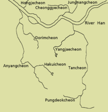
The Anyangcheon is a river in Gyeonggi-do and Seoul, South Korea. It has its source on the slopes of Mount Gwanggyo in the city of Uiwang[1] and flows north, through the city of Gunpo, where a major cleanup operation saw several species of birds return to the area in 2005.[2] Here, though, the water table remains depleted.[3] The river then flows through Anyang City,[4] where it is met by its major tributary, the Hakuicheon stream. From here, it loops around to the west before continuing north to the border with Gwangmyeong City. As the river passes to the west of Mount Gwanak, it forms the border between Gwangmyeong and Seoul, where it is lined on the Gwangmyeong side with rape fields and cherry blossom trees.[5] After the stream is joined near Guil Station from the west by the Mokgamcheon stream, which forms another border between Gwangmyeong and Seoul, it is then totally within the capital. Here, it is also joined from the east by the Dorimcheon and passes through a conservation zone for migratory birds[6] which was established after a 2005 cleanup operation,[7] whereafter it joins the Han. Most of the length of the river has a path alongside providing easy access, the only parts without this lying in Uiwang. Seoul City Council has embarked on a programme of exclusive cycle path creation alongside its waterways, including the Anyangcheon, to be completed in 2010.[8]
Wildlife
The Anyangcheon is home to a variety of wildlife. The dominant fish of the river are Zacco platypus (freshwater minnow) and Rhynchocypris oxycephalus in the more upstream areas near the source, and Carassius auratus (goldfish) further downstream, by Gwangmyeong.[3] The river also houses a number of species of birds, including the egrets, the grey heron, northern shoveler, common teal and mallard.[9] A conservation area has been established close to the confluence with the Han River, where the footpath is set back from the riverside to leave migratory birds a more natural setting.[6]
Gallery
-

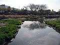
The source on the slopes of Gwanggyosan
-

The far upper reaches by Uiwang I.C.
-

Looking upstream in Uiwang
-
Looking downstream in Uiwang
-
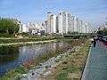
Looking downstream along the upper part in Gunpo
-
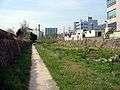
A bamboo-lined path beside the stream in Gunpo
-

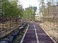
Looking upstream along a mid-width section in Uiwang
-
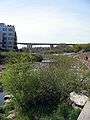
Looking downstream to the Seoul Orbital Motorway
-
Looking downstream at the Anyangcheon from the end of the Hakuicheon
-
Looking upstream to the point of confluence with the Hakuicheon
-
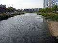
Downstream from the confluence with the Hakuicheon
See also
References
- ↑ "Uiwang Environment Map". Uiwang City Council. Retrieved 2009-04-20.
- ↑ "Visible Achievement for River Water Quality Improvement". Korea Environmental Technology Exchange. Retrieved 2009-04-21.
- 1 2 "Integrated watershed management for mitigating streamflow depletion in an urbanized watershed in Korea" (PDF). Kil Seong Lee, Eun-Sung Chung, and Young-Oh Kim, of the School of Civil and Environmental Engineering, Seoul National University. Retrieved 2009-04-21.
- ↑ "Welcome to Digital Anyang". Anyang City Council. Retrieved 2009-04-20.
- ↑ "Anyangcheon Park". Gwangmyeong City Council. Retrieved 2009-04-21.
- 1 2 "Conservation zone for migratory birds". Seoul City Council. Retrieved 2009-04-20.
- ↑ "Seoul Bustles with Stream Cleaning Activities". Seoul City Council. Retrieved 2009-04-20.
- ↑ "Cycling-only roads to be constructed by 2010". Seoul City Council. Retrieved 2009-04-20.
- ↑ "Bird News November 2008". Birds Korea. Archived from the original on 21 March 2009. Retrieved 2009-04-21.
Coordinates: 37°33′N 126°53′E / 37.550°N 126.883°E