Antler, North Dakota
| Antler, North Dakota | |
|---|---|
| City | |
|
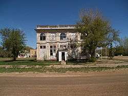
former U.S. Customs house in Antler | |
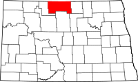
 Location of Antler, North Dakota | |
| Coordinates: 48°58′17″N 101°16′55″W / 48.97139°N 101.28194°WCoordinates: 48°58′17″N 101°16′55″W / 48.97139°N 101.28194°W | |
| Country | United States |
| State | North Dakota |
| County | Bottineau |
| Founded | 1905 |
| Area[1] | |
| • Total | 0.17 sq mi (0.44 km2) |
| • Land | 0.17 sq mi (0.44 km2) |
| • Water | 0 sq mi (0 km2) |
| Elevation | 1,535 ft (468 m) |
| Population (2010)[2] | |
| • Total | 27 |
| • Estimate (2014)[3] | 28 |
| • Density | 158.8/sq mi (61.3/km2) |
| Time zone | Central (CST) (UTC-6) |
| • Summer (DST) | CDT (UTC-5) |
| ZIP code | 58711 |
| Area code(s) | 701 |
| FIPS code | 38-02660 |
| GNIS feature ID | 1027718[4] |
Antler is a city in Bottineau County in the State of North Dakota. The population was 27 at the 2010 census.[5] Antler was founded in 1905.
History
Antler was established as a rural post office in 1898. It moved to its present location in 1902 to be closer to the Great Northern Railway to the south. The town was formally platted and founded in 1905, and reached a population of 342 by the 1910 Census.[6][7] The population declined to 101 by the 1980 Census,[8] and just 47 as of the 2000 census.[9]

Antler's last school closed in 1981. Fearing the end of their town, Rick Jorgensen and Harley "Bud" Kissner thought of ways to bring in newcomers with school-age children to the town with the intent of keeping the school open.[6] Rick thought of the idea to give away land and Bud volunteered some of his 640-acre (2.6 km2) farm to modern homesteaders. The deal was to stay for 5 years and enroll the children in the Antler elementary school. Rick drew up a newspaper ad while a wire service spread the story. The story made national network news aired twice on NBC evening edition with the first story stating the reason was to increase the population and the second story about its role in reopening of the town's schools by the land giveaway. Rick received letters from all over including international letters from Germany and Australia. The plan worked for just a few years,[6] with 6 families receiving plots of 5 or 9 acres (36,000 m2).[10]
White nationalists
In 2015, after failing to turn Leith into an all white community, Craig Cobb moved to Sherwood, near Antler. Craig has expressed a desire to turn the town into a white nationalist community.[11]
Geography
Antler is located in Antler Township along the United States border with Canada. According to the United States Census Bureau, the city has a total area of 0.17 square miles (0.44 km2), all of it land.[1] Both Antler and the surrounding township are named for nearby Antler Creek, whose branches resemble deer antlers when viewed on a map.[6]
Demographics
| Historical population | |||
|---|---|---|---|
| Census | Pop. | %± | |
| 1910 | 342 | — | |
| 1920 | 265 | −22.5% | |
| 1930 | 318 | 20.0% | |
| 1940 | 254 | −20.1% | |
| 1950 | 217 | −14.6% | |
| 1960 | 210 | −3.2% | |
| 1970 | 135 | −35.7% | |
| 1980 | 101 | −25.2% | |
| 1990 | 74 | −26.7% | |
| 2000 | 47 | −36.5% | |
| 2010 | 27 | −42.6% | |
| Est. 2015 | 28 | [12] | 3.7% |
| U.S. Decennial Census[13] 2014 Estimate[3] | |||
2010 census
As of the census[2] of 2010, there were 27 people, 16 households, and 6 families residing in the city. The population density was 158.8 inhabitants per square mile (61.3/km2). There were 29 housing units at an average density of 170.6 per square mile (65.9/km2). The racial makeup of the city was 96.3% White and 3.7% Native American. Hispanic or Latino of any race were 3.7% of the population.
There were 16 households of which 12.5% had children under the age of 18 living with them, 31.3% were married couples living together, 6.3% had a male householder with no wife present, and 62.5% were non-families. 62.5% of all households were made up of individuals and 43.8% had someone living alone who was 65 years of age or older. The average household size was 1.69 and the average family size was 2.83.
The median age in the city was 53.5 years. 14.8% of residents were under the age of 18; 3.7% were between the ages of 18 and 24; 11.1% were from 25 to 44; 37% were from 45 to 64; and 33.3% were 65 years of age or older. The gender makeup of the city was 51.9% male and 48.1% female.
2000 census
As of the 2000 Census, there were 47 people, 24 households, and 13 families residing in the city. The population density was 264.5 people per square mile (100.8/km²). There were 44 housing units at an average density of 247.6 per square mile (94.4/km²). The racial makeup of the city was 100.00% white. Residents identified themselves as having predominately European ancestry, with the largest three being Norwegian (25.5%), Swedish (14.5%), and German (10.9%).[9]
There were 24 households out of which 16.7% had children under the age of 18 living with them, 50.0% were married couples living together, and 45.8% were non-families. 41.7% of all households were made up of individuals and 25.0% had someone living alone who was 65 years of age or older. The average household size was 1.96 and the average family size was 2.69.
In the city the population was spread out with 21.3% under the age of 18, 2.1% from 18 to 24, 27.7% from 25 to 44, 23.4% from 45 to 64, and 25.5% who were 65 years of age or older. The median age was 45 years. For every 100 females there were 88.0 males. For every 100 females age 18 and over, there were 85.0 males.[14]
The median income for a household in the city was $16,250, and the median income for a family was $58,000. Males had a median income of $38,750 versus $25,000 for females. The per capita income for the city was $12,516. There were no families and 10.9% of the population living below the poverty line, including no under eighteens and 20.0% of those over 64.[9]
Attractions
Antler is the home of what was previously the world's largest historical quilt.[15]
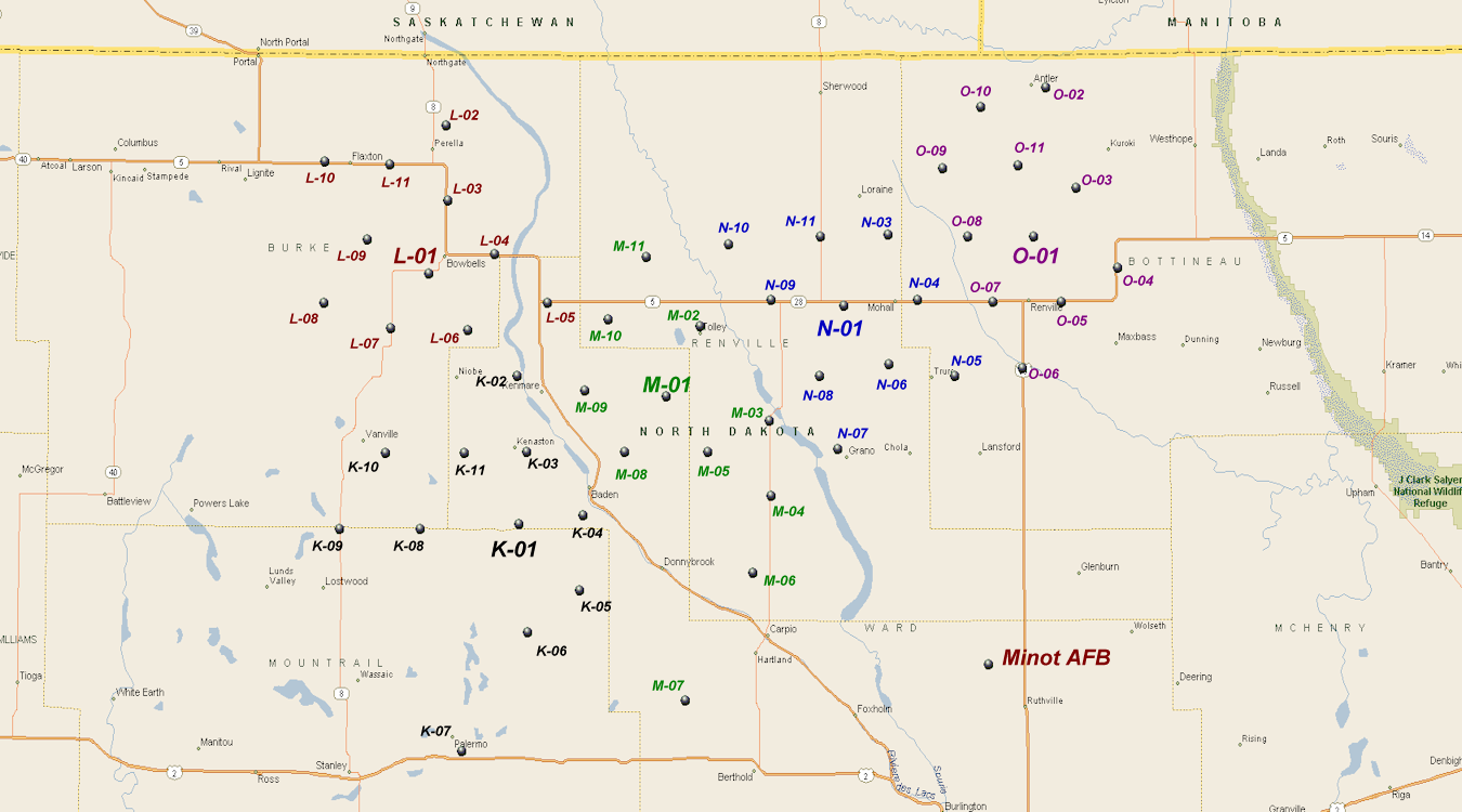
Antler is home to the O-2 Flight, "King Stag", LGM-30 Minuteman Nuclear Missile silo (48-58-01 North, 101-15-36 West), with the distinction of being the closest continental nuclear missile to a Nuclear-missile-free Canada. The site is manned by Missile Operations Flights, Operation Support Flight, and Security Forces Flight crews from the 742d Missile Squadron of the 91st Missile Wing
"Rough Riders", based out of Minot AFB, Minot, North Dakota.[16]
References
- 1 2 "US Gazetteer files 2010". United States Census Bureau. Archived from the original on 2012-01-24. Retrieved 2012-06-14.
- 1 2 "American FactFinder". United States Census Bureau. Retrieved 2012-06-14.
- 1 2 "Population Estimates". United States Census Bureau. Retrieved July 10, 2015.
- ↑ "US Board on Geographic Names". United States Geological Survey. 2007-10-25. Retrieved 2008-01-31.
- ↑ "2010 Census Redistricting Data (Public Law 94-171) Summary File". American FactFinder. United States Census Bureau. Archived from the original on 26 July 2011. Retrieved 2 May 2011.
- 1 2 3 4 Wick, Douglas A. North Dakota Place Names. Hedemarken Collectibles. p. 6. ISBN 0-9620968-0-6.
- ↑ U.S. Census Bureau (1913). "Number of Inhabitants, North Dakota" (PDF). Thirteenth Census of the United States: 1910. Government Printing Office. Retrieved 2008-07-20.
- ↑ U.S. Census Bureau (1981). "Number of Inhabitants, North Dakota" (PDF). 1980 Census of Population and Housing. Government Printing Office. Retrieved 2008-07-20.
- 1 2 3 U.S. Census Bureau. Census 2000. "Census Demographic Profiles, Antler, North Dakota" (PDF). CenStats Databases. Retrieved 2009-01-31.
- ↑ O'Neill, Thomas (1984). Lakes, Peaks, and Prairies: Discovering the US-Canadian Border. National Geographic Society. ISBN 0-87044-478-6.
- ↑ "Cobb puts his focus on Antler". Bismarck Tribune. June 11, 2015.
- ↑ "Annual Estimates of the Resident Population for Incorporated Places: April 1, 2010 to July 1, 2015". Retrieved July 2, 2016.
- ↑ United States Census Bureau. "Census of Population and Housing". Archived from the original on May 11, 2015. Retrieved June 17, 2014.
- ↑ U.S. Census Bureau. Census 2000. "QT-P1. Age Groups and Sex, Antler, North Dakota". American FactFinder. <http://factfinder.census.gov>. Retrieved 2009-01-31.
- ↑ "World's Largest Historical Quilt". Roadside America.com. Retrieved 2009-07-26.
- ↑ Kirkpatrick, Jim. "Minuteman Missile Site Coordinates". University of Wyoming. Archived from the original on 4 October 2013. Retrieved 23 May 2013.
External links
| Wikivoyage has a travel guide for Antler. |
- "Antler, ND" (Pictures). Ghosts of North Dakota. Retrieved 2012-12-27.