Antingham
| Antingham | |
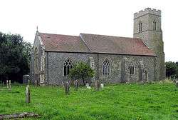 St Mary and St Margaret, Antingham, Norfolk |
|
 Antingham |
|
| Area | 6.12 km2 (2.36 sq mi) |
|---|---|
| Population | 355 (parish, 2011 census) |
| – density | 58/km2 (150/sq mi) |
| OS grid reference | TG252329 |
| – London | 134 miles |
| Civil parish | Antingham |
| District | North Norfolk |
| Shire county | Norfolk |
| Region | East |
| Country | England |
| Sovereign state | United Kingdom |
| Post town | NORTH WALSHAM |
| Postcode district | NR28 |
| Police | Norfolk |
| Fire | Norfolk |
| Ambulance | East of England |
| EU Parliament | East of England |
| UK Parliament | North Norfolk |
Coordinates: 52°51′09″N 1°21′07″E / 52.8525°N 1.35188°E
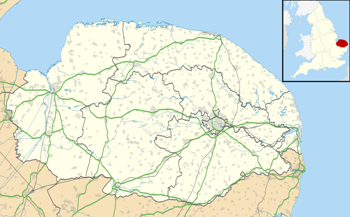
Antingham is a village and civil parish in the north of the English county of Norfolk. The village is located about 6 miles (9.7 km) south of Cromer and 3 miles (4.8 km) north of North Walsham. The nearest railway station is at Gunton for the Bittern Line which runs between Sheringham, Cromer and Norwich.The nearest Airport is at Norwich which is 17.5 miles (28.2 km) south of the village. The civil parish has an area of 6.12 square kilometres and in the 2001 census had a population of 287 in 120 households, the population increasing to 355 at the 2011 Census.[1] For the purposes of local government, the parish falls within the district of North Norfolk.
Location
The parish of Antingham has boundaries with seven other neighbouring parishes. To the north are the parishes of Thorpe Market and Southrepps. The eastern boundary, which follows the River Ant, is with Swafield, and south are the parishes of North Walsham and Felmingham. To west lies the parishes of Hanworth and Suffield with most of this boundary following the edge of Gunton Park. The parish is dissected north to south by the A149 road from King’s Lynn to Great Yarmouth .[2] The parish also straddles the railway line which runs between Sheringham, Cromer and Norwich. In the south east corner of the parish are Antingham Ponds which are the source of the River Ant, a tributary of the River Bure.
Description
The village of Antingham sits astride the Southrepps road which is on the eastern side of the A149[3] and runs north to south from that road to the village of Southrepps. The centre of the village is at the crossroads of Elderton Lane, Sandy Lane and Southrepps Road. There is a level crossing on Southrepps Road 200 meters south of this crossroads. The parish church can be found in the south of the village close to the A149 in Church Lane. The parish church is called Saint Mary's and stands next to the ruins of Saint Margaret’s Church which was abandoned in the late 17th century, when material from Saint Margaret's was used to repair Saint Mary's, after they had both fallen into disrepair.
History
Name origin
The name of Antingham originates from an Old English word meaning homestead of the family or followers of a man called Anta.[4]
The Domesday Book
Antingham has an entry in the Domesday Book of 1085 where the village, its population, records of land ownership, and details about productive resources were extensively detailed.[5] In the survey Antingham is variously recorded by the names Antigeham, Antingham, and Attinga.
According to the Domesday Book the main tenants at the time were Roger Bigot and Thurston Fitzguy. The survey notes the presence of four villagers and four smallholders on the land. A meadow, acreage, and ploughs of various values are among the items recorded in Antingham's entry in the Domesday Book.[6]
References
- ↑ "Civil Parish population 2011". Retrieved 31 August 2015.
- ↑ Ordnance Survey, Explorer Sheet 252, Norfolk Coast East, ISBN 978-0-319-46726-8
- ↑ County A to Z Atlas, Street & Road maps Norfolk, page 40, Antingham ISBN 978-1-84348-614-5
- ↑ A Popular Guide to Norfolk Place-names: by James Rye: Published by Larks press, Dereham, Norfolk, 2000 ; ISBN 0-948400-15-3
- ↑ The Domesday Book, England's Heritage, Then and Now, (Editor: Thomas Hinde), Norfolk, page 186, Antingham, ISBN 1-85833-440-3
- ↑ Domesday Book, Norfolk, Part I and Part II, 33, Morris, J. (General Editor), 1984. Published: Phillimore & Co. ISBN 0-85033-479-9
- ^ Office for National Statistics & Norfolk County Council (2001). Census population and household counts for unparished urban areas and all parishes. Retrieved December 2, 2005.
External links
| Wikimedia Commons has media related to Antingham. |
- Information from Genuki Norfolk on Antingham.
- Antingham Bone Mills
- Antingham in the Domesday Book