Antarctic Bottom Water
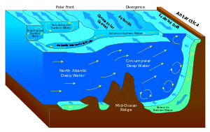
The Antarctic bottom water (AABW) is a type of water mass in the Southern Ocean surrounding Antarctica with temperatures ranging from -0.8 to 2 °C (35 °F), salinities from 34.6 to 34.7 psu. Being the densest water mass of the World Ocean, AABW is found to occupy the depth range below 4000 m of all ocean basins that have a connection to the Southern Ocean at that level.[1] The major significance of Antarctic bottom water is that it is the coldest bottom water, giving it a significant influence on the movement of the world's oceans. Antarctic bottom water also has a high oxygen content relative to the rest of the oceans' deep waters. This is due to the oxidation of deteriorating organic content in the rest of the deep oceans. Antarctic bottom water has thus been considered the ventilation of the deep ocean.
Formation and circulation
Antarctic bottom water is created in part due to the major overturning of ocean water.
Antarctic bottom water is formed in the Weddell and Ross Seas, off the Adélie Coast and by Cape Darnley from surface water cooling in polynyas and below the ice shelf.[2] A unique feature of Antarctic bottom water is the cold surface wind blowing off the Antarctic continent.[3] The surface wind creates the polynyas which opens up the water surface to more wind. This Antarctic wind is stronger during the winter months and thus the Antarctic bottom water formation is more pronounced during the Antarctic winter season. Surface water is enriched in salt from sea ice formation. Due to its increased density, it flows down the Antarctic continental margin and continues north along the bottom. It is the densest water in the free ocean, and underlies other bottom and intermediate waters throughout most of the southern hemisphere. The Weddell Sea Bottom Water is the densest component of the Antarctic bottom water.
Evidence indicates that Antarctic bottom water production through the Holocene (last 10,000 years) is not in a steady-state condition,[4] that is to say that bottom water production sites shift along the Antarctic margin over decade to century timescales as conditions for the existence of polynas change. For example, the calving of the Mertz Glacier, which occurred on 12–13 February 2010, dramatically changed the environment for producing bottom water, reducing export by up to 23% in the region of Adelie Land.[5] Evidence from sediment cores, containing layers of cross-bedded sediments indicating phases of stronger bottom currents, collected on the Mac.Robertson shelf [6] and Adélie Land[7] suggests that they have switched "on" and "off" again as important bottom water production sites over the last several thousand years.

Atlantic Ocean
The Vema Channel, a deep through in the Rio Grande Rise of the South Atlantic at 31°18′S 39°24′W / 31.3°S 39.4°W, is an important conduit for Antarctic Bottom Water and Weddell Sea Bottom Water migrating north.[8] Upon reaching the equator, about one-third of the northward flowing Antarctic bottom water enters the Guiana Basin, mainly through the southern half of the Equatorial Channel at 35°W. The other part recirculates and some of it flows through the Romanche Fracture Zone into the eastern Atlantic. In the Guiana Basin, west of 40°W, the sloping topography and the strong, eastward flowing deep western boundary current might prevent the Antarctic bottom water from flowing west: thus it has to turn north at the eastern slope of the Ceará Rise. At 44°W, north of the Ceará Rise, Antarctic bottom water flows west in the interior of the basin. A large fraction of the Antarctic bottom water enters the eastern Atlantic through the Vema Fracture Zone.[9]

Indian Ocean
In the Indian Ocean the Crozet-Kerguelen Gap allows Antarctic bottom water to move toward the equator. This northward movement amounts to 2.5 Sv. It takes the Antarctic Bottom Water 23 years to reach the Crozet-Kerguelen Gap.[10] South of Africa, Antarctic bottom water flow northwards through the Agulhas Basin and then east through the Agulhas Passage and over the southern margins of the Agulhas Plateau from where it is transported to into the Mozambique Basin.[11]
References
- ↑ "AMS Glossary, Antarctic Bottom Water". American Meteorological Society. Retrieved 2012-02-20.
- ↑ Talley, Lynne (1999). "Some aspects of ocean heat transport by the shallow, intermediate and deep overturning circulations". Geophysical Monographs. 112: 1–22.
- ↑ Massom, R., Michael, K., Harris, P.T., Potter, M.J., 1998. The distribution and formative processes of latent heat polynyas in East Antarctica. Annals of Glaciology 27, 420-426.
- ↑ Broecker, W. S., Peacock, S. L., Walker, S., Weiss, R., Fahrbach, E., Schroeder, M., Mikolajewicz, U., Heinze, C., Key, R., Peng, T. H., Rubin, S., 1998. How much deep water is formed in the Southern Ocean? Journal of Geophysical Research, 103 (C8), 15833-15843.
- ↑ Kusahara, K., Hasumi, H., Williams, G.D., 2011. Impact of the Mertz Glacier Tongue calving on dense water formation and export. Nature Communications 2.
- ↑ Harris, P.T., 2000. Ripple cross-laminated sediments on the East Antarctic shelf: evidence for episodic bottom water production during the Holocene? Marine Geology 170, 317-330.
- ↑ Harris, P.T., Brancolini, G., Armand, L., Busetti, M., Beaman, R.J., Giorgetti, G., Prestie, M., Trincardi, F., 2001. Continental shelf drift deposit indicates non-steady state Antarctic bottom water production in the Holocene. Marine Geology 179, 1-8.
- ↑ "AMS Glossary, Vema Channel". American Meteorological Society. Retrieved 2012-02-20.
- ↑ Rhein, Monika; Stramma, Lothar; Krahmann, Gerd (1998). "The spreading of Antarctic bottom water in the tropical Atlantic" (PDF). Deep-Sea Research Part I. 45: 507–527. Bibcode:1998DSRI...45..507R. doi:10.1016/S0967-0637(97)00030-7. Retrieved 2012-02-14.
- ↑ Haine, T. W. N.; Watson, A. J.; Liddicoat, M. I.; Dickson, R. R. (1998). "The flow of Antarctic bottom water to the southwest Indian Ocean estimated using CFCs". Journal of Geophysical Research. 103: 27637. Bibcode:1998JGR...10327637H. doi:10.1029/98JC02476.
- ↑ Uenzelmann-Neben, G.; Huhn, K. (2009). "Sedimentary deposits on the southern South African continental margin: Slumping versus non-deposition or erosion by oceanic currents?" (PDF). Marine Geology. 266: 65–79. doi:10.1016/j.margeo.2009.07.011. Retrieved April 2015. Check date values in:
|access-date=(help)
- Glossary of Physical Oceanography
- Steele, John H., Steve A. Thorpe and Karl K. Turekian, editors, Ocean Currents: A derivative of the Encyclopedia of Ocean Sciences, Academic Press, 1st ed., 2010 ISBN 978-0-08-096486-7
- Seabrooke, James M., Hufford, Gary L., and Elder, Robert B., “Formation of Antarctic Bottom Water in the Weddell Sea,” Journal of Geophysical Research, Vol. 76, No. 9, pp. 2164–2178, 1971
- Fahrbach, E., G. Rohardt, N. Scheele, M. Schroder, V. Strass, and A. Wisotzki, “Formation and discharge of deep and bottom water in the northwestern Weddell Sea”, Journal of Maritime Research, 53(4), pp. 515–538, 1995