Angaur
| Angaur アンガウル (Japanese) | ||
|---|---|---|
| State | ||
| ||
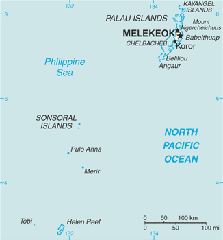
 Location of Angaur in Palau | ||
| Country |
| |
| Capital | Ngeremasch | |
| Area | ||
| • Total | 8 km2 (3 sq mi) | |
| Population (2013) | ||
| • Total | 130 | |
| • Density | 16/km2 (42/sq mi) | |
| ISO 3166 code | PW-010 | |

Angaur (Japanese: アンガウル Hepburn: Angauru) or Ngeaur is an island in the island nation of Palau. The island, which forms its own state, has an area of 8 km² (3 mi²). Its population was 130 in 2012.[1] The state capital is the village of Ngeremasch on the western side. A second village, Rois, is immediately east of Ngeremasch.
The first sighting of Angaur, Babeldaob, Koror, and Peleliu recorded by Westerners was by the Spanish expedition of Ruy López de Villalobos at the end of January 1543. They were then charted as Los Arrecifes (The Reefs in Spanish).[2] In November and December 1710 these three islands were again visited and explored by the Spanish missionary expedition commanded by Sargento Mayor Francisco Padilla on board of the patache Santísima Trinidad. Two years later they were explored in detail by the expedition of Spanish naval officer Bernardo de Egoy.[3]
From 1909 until 1954 phosphate mining took place on Angaur, originally by the Germans, then the Japanese, and finally by Americans. Angaur is the site of a major World War II battle. The Battle of Angaur was part of the larger offensive campaign called Operation Forager that ran from June to Nov 1944. Many American and Japanese battle relics[4] remain scattered throughout the island. Angaur is the only place in Micronesia that has feral monkeys; they are descended from macaques that escaped during the period of German occupation.[5] Thus it is also called Monkey Island.
Angaur Island is located southwest of Peleliu, and it is a popular surfing location. Angaur is accessible by boats and small planes, and Belau Air has service to Angaur Airstrip. From 1945 to 1978 the U.S. Coast Guard operated a LORAN transmitting station, LORSTA Palau, as part of the worldwide LORAN navigation system. The eastern side of the island is mostly sandy with rocky outcroppings, while the western side of the island has a small lagoon with a small fishing and transportation port.
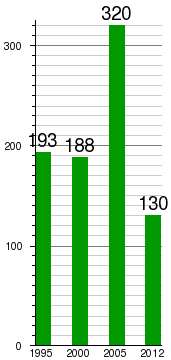
Population development:[1]
Japanese as an official language
According to the state constitution of 1982, Angaur's official languages are Palauan, English and Japanese.[6] It is the only place in the world where Japanese is an official language, as it is not the official but rather the de facto national language of Japan. However, results of the latest census show that in April 2005, there were neither usual nor legal residents of Angaur aged 5 years or older who spoke Japanese at home at all.[7] No person reported or was reported to be of Japanese ethnic origin for Angaur.[8] One person born (but apparently not residing) on Angaur reported to speak Japanese and Palauan equally often at home.[7] The 2012 mini census shows 7 people aged 10 years or older literate in any language other than Palauan and English for Angaur, out of a total population of 130.[1]
See also
References
- 1 2 3 "2013 ROP Statistical Yearbook" (PDF). Bureau of Budget & Planning. Retrieved 4 August 2014.
- ↑ Burney, James A chronological history of the discoveries in the South Sea or Pacific Ocean, London, 1813, v.I, p.233.
- ↑ Coello, Francisco "Conflicto hispano-alemán" Boletín de Sociedad Geográfica de Madrid, t.XIX. 2º semestre 1885, Madrid, p.296.
- ↑ Panoramio photos of Japanese command post on north end of Angaur Island, Palau.
- ↑ Micronesia Handbook by Neil M. Levy, pp. 174–176
- ↑ "Constitution of the State of Angaur". Pacific Digital Library. Article XII. Retrieved 4 August 2014.
The traditional Palauan language, particularly the dialect spoken by the people of Angaur State, shall be the language of the State of Angaur. Palauan, English and Japanese shall be the official languages.
- 1 2 "2005 Census of Population & Housing" (PDF). Bureau of Budget & Planning. Retrieved 4 August 2014.
- ↑ "2005 Census Monograph Final Report" (PDF). Bureau of Budget & Planning. Retrieved 4 August 2014.
External links
Coordinates: 6°54′N 134°08′E / 6.900°N 134.133°E