Andabeløya
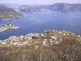 Main buildings seen from Nonsknuten. North is up in the picture, and Flekkefjord lies between the mountains. | |
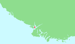 Location of the island | |
| Geography | |
|---|---|
| Location | Vest-Agder, Norway |
| Coordinates | 58°13′05″N 6°40′55″E / 58.2180°N 06.6820°ECoordinates: 58°13′05″N 6°40′55″E / 58.2180°N 06.6820°E |
| Area | 4.7 km2 (1.8 sq mi) |
| Length | 4 km (2.5 mi) |
| Width | 2 km (1.2 mi) |
| Highest elevation | 206 m (676 ft) |
| Highest point | Brendøyknuten |
| Administration | |
| County | Vest-Agder |
| Municipality | Flekkefjord |
| Demographics | |
| Population | 100 (2015) |
Andabeløya or Andabeløyna is a populated island in Flekkefjord municipality in Vest-Agder county, Norway. The 4.7-square-kilometre (1.8 sq mi) island lies at the mouth of the Fedafjorden, just east of the island of Hidra. The one village on the island is called Andabeløy.
The island is very mountainous and rugged with all the island's population lives in the village of Andabeløy, located at the relatively flat northern end of the island. In 2015, there were about 100 residents living on the island. The island is connected to the mainland by a ferry at the north end of the island.[1]
See also
References
- ↑ Store norske leksikon. "Andabeløy" (in Norwegian). Retrieved 2016-09-07.
External links
This article is issued from Wikipedia - version of the 11/11/2016. The text is available under the Creative Commons Attribution/Share Alike but additional terms may apply for the media files.