Anctoville
| Anctoville | |
|---|---|
 | |
 Anctoville | |
|
Location within Normandy region  Anctoville | |
| Coordinates: 49°06′22″N 0°42′20″W / 49.1061°N 0.7056°WCoordinates: 49°06′22″N 0°42′20″W / 49.1061°N 0.7056°W | |
| Country | France |
| Region | Normandy |
| Department | Calvados |
| Arrondissement | Bayeux |
| Canton | Caumont-l'Éventé |
| Intercommunality | Villers-Bocage Intercom |
| Government | |
| • Mayor (2008–2020) | Gérard Leguay |
| Area1 | 17.48 km2 (6.75 sq mi) |
| Population (2009)2 | 1,056 |
| • Density | 60/km2 (160/sq mi) |
| Time zone | CET (UTC+1) |
| • Summer (DST) | CEST (UTC+2) |
| INSEE/Postal code | 14011 / 14240 |
| Elevation |
62–158 m (203–518 ft) (avg. 90 m or 300 ft) |
|
1 French Land Register data, which excludes lakes, ponds, glaciers > 1 km² (0.386 sq mi or 247 acres) and river estuaries. 2 Population without double counting: residents of multiple communes (e.g., students and military personnel) only counted once. | |
Anctoville is a French commune in the Calvados department in the Normandy region of north-western France.
The inhabitants of the commune are known as Anctovillais or Anctovillaises[1]
Geography
Anctoville is located some 30 km south-west of Caen and 5 km north-west of Villers-Bocage in the Bessin area in the Seulles valley. It can be accessed by the D67 road from Saint-Germain-d'Ectot in the north passing through the village and continuing south-east to Villers-Bocage. The D92 road also passes through the length of the commune and the village from south-west to north-east. In the north-east of the commune the D33 road from Longraye in the north passes through and continues south-east to Villers-Bocage. Finally in the north-east is also the D173A road connecting the D92 and the D67. The commune consists entirely of farmland except for two small areas of forest in the north.
The Ruisseau des Landes forms a part of the northern border. Le Candon stream passes through the commune flowing towards the north-east and forming part of the northern border of the commune. Le Seulles stream forms part of the southern border before flowing just south of the village then continuing north-east to form most of the eastern border joining Le Candon at the northern tip of the commune. The Ruisseau David forms the south-eastern border and flows north to join Le Seulles. Le Gallichon stream also forms part of the southern border before joining Le Seulles in the south.[2]
Neighbouring communes and villages[2]
 |
Saint-Germain-d'Ectot | Longraye | Vendes | |
| Livry | |
Saint-Louet-sur-Seulles | ||
| ||||
| | ||||
| Caumont-l'Evente | Amayé-sur-Seulles | Villers-Bocage |
History
The name Anctoville comes from Asketillville' meaning "Anquetil farm" (Anquetoville then later Anctoville). Cf. Ancretteville-sur-Mer.
The former name of Anctoville was Coisnières or Cornières until 1616.[3] Olivier Foulognes, the King's butler, bought the Lordship of Cornières and obtained a change of name. This fief became part of the Bailiwick of Briquessart. The oldest document showing what was the Parish of Coisnières dates from the 12th century. It was a charter of confirmation of goods given by Henry, King of England and Duke of Normandy, at Lessay.[4]
In June 1944 during the Battle of Villers-Bocage Orbois castle housed the headquarters of the German armoured division Panzer Lehr commanded by Fritz Bayerlein.[5] Anctoville was liberated on 1 August 1944 by the British 61st reconnaissance battalion.[6] These events inspired a scenario in the video game Call of Duty 2 on the Xbox 360.[7]
In 1973, Anctoville (population 394 in 1968) merged with Feuguerolles-sur-Seulles (with 70 inhabitants to the east of the territory), Orbois (120 inhabitants in the north), and Sermentot (182 inhabitants in the north-east).[8] The communes retained the status of Associated communes of France.
Administration
List of Successive Mayors[9]
| From | To | Name | Party | Position |
|---|---|---|---|---|
| ? | 2001 | Albert Marie | ||
| 2001 | 2020 | Gérard Leguay | Farmer |
(Not all data is known)
The council is composed of fifteen members:
- seven representing Anctoville,
- two representing the associated commune of Feuguerolles-sur-Seulles and one delegated mayor
- two representatives of Orbois and one delegated mayor
- four representatives of Sermentot and one delegated mayor
The mayor is assisted by two deputies.
Demography
In 2009 the commune had 1,056 inhabitants. The evolution of the number of inhabitants is known through the population censuses conducted in the commune since 1793. From the 21st century, a census of communes with fewer than 10,000 inhabitants is held every five years, unlike larger towns that have a sample survey every year.[Note 1]
| 1793 | 1800 | 1806 | 1821 | 1831 | 1836 | 1841 | 1846 | 1851 |
|---|---|---|---|---|---|---|---|---|
| 1,134 | 910 | 1,210 | 1,167 | 1,173 | 1,173 | 1,112 | 1,043 | 1,047 |
| 1856 | 1861 | 1866 | 1872 | 1876 | 1881 | 1886 | 1891 | 1896 |
|---|---|---|---|---|---|---|---|---|
| 998 | 920 | 931 | 848 | 830 | 775 | 721 | 758 | 713 |
| 1901 | 1906 | 1911 | 1921 | 1926 | 1931 | 1936 | 1946 | 1954 |
|---|---|---|---|---|---|---|---|---|
| 723 | 714 | 742 | 595 | 574 | 563 | 500 | 511 | 432 |
| 1962 | 1968 | 1975 | 1982 | 1990 | 1999 | 2006 | 2009 | - |
|---|---|---|---|---|---|---|---|---|
| 430 | 394 | 751 | 817 | 850 | 905 | 1,024 | 1,056 | - |
Sources : Ldh/EHESS/Cassini until 1962, INSEE database from 1968 (population without double counting and municipal population from 2006)

Anctoville itself had 1,210 inhabitants in 1806. The four communes that merged in 1973 had a total of 2,608 inhabitants in 1836 (1,173 in Anctoville, 299 in Feuguerolles-sur-Seulles, 233 in Orbois, and 903 in Sermentot).[8]
Economy
The commune has an essentially agriculture oriented economy. At the communal inventory of 1998 it had 46 farms, 28 of which were of a professional standard classified by INSEE, for an area of 1,848 hectares used. There were 68 farms in 1988. The main production is the raising of cattle for milk and meat. Arable land is used for forage and grain crops.[10]
Culture and heritage

Civil heritage
- The Orphanage Pierre Rayer was founded in 1883. This establishment occupied a castle from the 18th century with buildings from the 19th century. It has become a children's home of a social nature
Religious heritage
- The Church of Saint Peter (12th-17th century)at Feuguerolles
- The Church of Saint-Aubin (12th-17th century) at Sermentot
- The Church of Saint Peter (Roman era and 14th century) at Orbois houses a Statue: Madonna and Child (15th century)
 which is classified as an historical object[11]
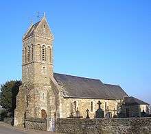
 - The Church of Saint Nicolas (1956)
 at Anctoville is registered as an historical monument[12]
Notable people linked to the commune
- Marie Rayer, daughter of Dr. Pierre François Olive Rayer and wife of Marquis Stanislas d'Escayrac de Lauture, bequeathed her estate to the commune to create an orphanage
- Jean-Claude Hallais (born 1948), horse driver, winner of the Prix d'Amerique in 1992, based his team in Anctoville
See also
External links
- Anctoville on Lion1906
- Anctoville on Google Maps
- Anctoville on Géoportail, National Geographic Institute (IGN) website (French)
- Anctoville on the 1750 Cassini Map
- Anctoville on the INSEE website (French)
- INSEE (French)
Notes and references
Notes
- ↑ At the beginning of the 21st century, the methods of identification have been modified by law No. 2002-276 of 27 February 2002 , the so-called "law of local democracy" and in particular Title V "census operations" which allow, after a transitional period running from 2004 to 2008, the annual publication of the legal population of the different French administrative districts. For communes with a population greater than 10,000 inhabitants, a sample survey is conducted annually, the entire territory of these communes is taken into account at the end of the period of five years. The first "legal population" after 1999 under this new law came into force on 1 January 2009 and was based on the census of 2006.
References
- ↑ Inhabitants of Calvados (French)
- 1 2 Google Maps
- ↑ Role of vassals and rear vassals of the Bailiwick of Caen in 1552, p. 276, Émile Travers
- ↑ Monumental Statistics of Calvados, Arcisse de Caumont
- ↑ panzerace.net - villers bocage Archived January 16, 2014, at the Wayback Machine. consulted on 4 January 2010
- ↑ The 61st in the Western Europe Campaign 1944, consulted on 6 January 2010
- ↑ Game Reviews Archived August 13, 2009, at the Wayback Machine.
- 1 2 Ehesse Cassini (French)
- ↑ List of Mayors of France
- ↑ Ministry of Food, Agriculture, and Fisheries, Agreste, Statistics, Evaluation and prospects for Agriculture - Communes consulted on 19 January 2010 (French)
- ↑ Ministry of Culture, Palissy PM14001062 Statue: Madonna and child
(French)

- ↑ Ministry of Culture, Mérimée EA14000001 Church of Saint Nicolas (French)
| Wikimedia Commons has media related to Anctoville. |