Alwar district

Alwar District is a district in Rajasthan, a state in northern India, with capital in the city of Alwar. The district covers 8,380 km2. It is bound on the north by Rewari district of Haryana, on the east by Bharatpur and Mewat district of Haryana, on the south by Dausa, and on the west by Jaipur districts.
As of 2011 it is the third most populous district of Rajasthan (out of 33) after Jaipur and Jodhpur.[1]
History
The first reference to Alwar goes back to the story of Prahald-Hiryanyakashyap, near Mahabharata, where the Pandavas lived their year in hidden exile (Virat Nagar), which is called Barath, the area gained prominence under the rulership of Gurjar Pratihars and their allies Badgujars. During the Sepoy Mutiny of 1857, Raja Bane Singh sent a force consisting mainly of Muslims and Rajputs, to relieve the British garrison in Agra. The Muslims deserted and the rest were defeated by the rebels. Pran Sukh Yadav, who fought beside Rao Tula Ram of Rewari in 1857, settled along with the kinsmen of dead soldiers at Village Nihalpura, Behror Tehsil, of Alwar District. It was a part of vast northern Indian empire known as Gurjara-Pratihara. The town was previously named as "Matsyanagar", meaning "the city of fishes".
Hemu, the last Hindu emperor of India, was born in Alwar district in the village 'Deveti Machheri'. He had won in all 22 battles against Afghans and Mughals, including two against Akbar and became Vikramaditya king at Delhi on 7 October 1556.
The city of Alwar is known as The Tiger Gate of Rajasthan. Enclosed by the Aravallis, Alwar gives the appearance of being carved marvellously from rocks. Flourishing deciduous forests and lakes covers the hills. These forests and basins serve as a home to numerous species of birds as well as animals. Situated amongst such beauty, the city proves to be a delight to the eyes.
Architectural wonders dot the city. Ironically, Alwar is the oldest as well the newest kingdom of the Rajputs. It is the oldest because its customs date far back to the kingdoms of Viratnagar, which flourished around 1500 B.C. Also known by the name of Matasya Desh. In this city, the Pandavas (heroes of Mahabharata) spent the last year of their exile of 13 years. It is believed that a member of the Kachh family belonging to Amber founded the city of Amber.
Industry
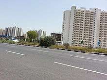
The district has industrial estates such as Alwar, Bhiwadi, Shahjahanpur, Neemrana, Behror where companies such as G. S. Pharmbutor, Ashok Leyland, Pepsi, Parryware, Kajaria Ceramics and Honda Motors have manufacturing plants.
Places of interest
Bala Qilla (Alwar fort) situated in the Aravali Hills is one of the best forts present in Rajasthan. It is said that it has never been invaded or conquered by any king. Just behind it is the Nikumbh Mahal. There are many small palaces in the city and an old museum with a collection of paintings, armours, and old weapons.
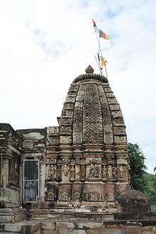
Neelkanth temple is an old temple dedicated to Lord Shiva, built between the 6th to the 9th century.
Bhangarh Haunted Fort
Banghar Fort is a haunted fort and the Archaeological Survey of India has put up a board on the fort gate that it is prohibited for tourists to stay inside the fort area after sunset and before sunrise. This fort has become a major tourist attraction.[2]
Sariska Tiger Reserve is also located in the district, and Arvari River flows through this district. Hill Fort Kesroli, currently a heritage hotel, is also nearby at Kesroli.
Demographics
According to the 2011 census Alwar district has a population of 3,671,999,[1] roughly equal to the nation of Liberia[3] or the US state of Oklahoma.[4] This gives it a ranking of 77th in India (out of a total of 640).[1] The district has a population density of 438 inhabitants per square kilometre (1,130/sq mi) .[1] Its population growth rate over the decade 2001-2011 was 22.7%.[1] Alwar has a sex ratio of 894 females for every 1000 males,[1] and a literacy rate of 71.68%.[1]
Transport
National Highway NH8 (Delhi-Jaipur-Ajmer-Ahmedabad-Bombay highway) passes through the Behror district. Alwar district is reached from New Delhi by NH8 or by Gurgaon-Sohna-Alwar highway that is being widened to six lanes.
Delhi-Jaipur railway line also passes through the district. Alwar city railway station is one of the railway stations in the district.
How to reach
The nearest airport to Alwar is Delhi Airport is 163 km away. Alwar can be easily reached by road as well. There are well-maintained roads linking it to tourism destinations like Delhi, Sariska, Bharatpur, Deeg and Jaipur. The railway network connects Alwar with Delhi, Jodhpur, Mumbai and other important tourist cities of India.
Rivers in Alwar
Alwar district does not have any perennial river. It has seasonal streams that carry water during rains. They are the Sahibi River at Sodawas and the Arvari River. Several small check dams have been built on these streams to collect rainwater.
References
- 1 2 3 4 5 6 7 "District Census 2011". Census2011.co.in. 2011. Retrieved 2011-09-30.
- ↑ http://articles.timesofindia.indiatimes.com/2013-07-15/travel/40589314_1_ghosts-fort-area-alwar
- ↑ US Directorate of Intelligence. "Country Comparison:Population". Retrieved 2011-10-01.
Liberia 3,786,764 July 2011 est.
- ↑ "2010 Resident Population Data". U. S. Census Bureau. Archived from the original on 2013-10-19. Retrieved 2011-09-30.
Oklahoma 3,751,351
- Powlett, P. W. (1838). Gazetteer of Ulwur (Alwar). London : Trübner & co.
External links
| Wikimedia Commons has media related to Alwar district. |
 |
Mahendragarh district, Haryana | Rewari district, Haryana | Mewat district, Haryana | |
| Jaipur district | |
|||
| ||||
| | ||||
| Dausa district | Bharatpur district |
| Outline | 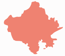 | ||||||||||||||||||||||||||
|---|---|---|---|---|---|---|---|---|---|---|---|---|---|---|---|---|---|---|---|---|---|---|---|---|---|---|---|
| Governance | |||||||||||||||||||||||||||
| Divisions and Districts |
| ||||||||||||||||||||||||||
| Major cities | |||||||||||||||||||||||||||
| Related templates |
| ||||||||||||||||||||||||||
Coordinates: 27°34′12″N 76°36′00″E / 27.57000°N 76.60000°E