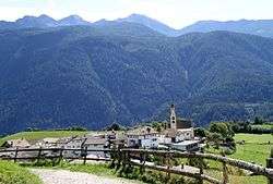
Altrei
| Altrei | ||
|---|---|---|
| Comune | ||
| Comune di Anterivo Gemeinde Altrei | ||
 | ||
| ||
 Altrei Location of Altrei in Italy | ||
| Coordinates: 46°17′N 11°22′E / 46.283°N 11.367°ECoordinates: 46°17′N 11°22′E / 46.283°N 11.367°E | ||
| Country | Italy | |
| Region | Trentino-Alto Adige/Südtirol | |
| Province / Metropolitan city | South Tyrol (BZ) | |
| Frazioni | Eben (Pramarino), Guggal | |
| Government | ||
| • Mayor | Gustav Mattivi | |
| Area | ||
| • Total | 11.1 km2 (4.3 sq mi) | |
| Population (Nov. 2010) | ||
| • Total | 384 | |
| • Density | 35/km2 (90/sq mi) | |
| Demonym(s) |
German: Altreier Italian: anterivesi | |
| Time zone | CET (UTC+1) | |
| • Summer (DST) | CEST (UTC+2) | |
| Postal code | 39040 | |
| Dialing code | 0462 | |
| Website | Official website | |

Altrei (German pronunciation: [alˈtraɪ̯]; Italian: Anterivo [anteˈriːvo]) is a comune (municipality) in South Tyrol in northern Italy.
Geography
Altrei is the only South Tyrolean municipality in the Fiemme Valley of the Southern Limestone Alps, located about 25 kilometres (16 mi) south of Bolzano half-way to the city of Trent. The surrounding communities of Capriana, Carano, Castello-Molina di Fiemme, and Valfloriana in the north, south and east all belong to the Trentino province, except for Truden in the northwest. In the southeast, the Altrei municipal area stretches down to the Avisio valley. Large parts belong to the Trudner Horn Nature Park.
As of 30 November 2010, Altrei had a population of 384 and an area of 11.1 square kilometres (4.3 sq mi).[1]
Frazioni
The municipality of Altrei contains the frazioni (subdivisions, mainly villages and hamlets) Eben (Pramarino) and Guggal.
Linguistic distribution
According to the 2011 census, 87.80% of the population speak German, 12.20% Italian as first language.[2]
|
Demographic evolution

History

Antereu was first mentioned in a 1321 deed issued by Count Henry of Gorizia-Tyrol, who had the area settled by German peasants. It was part of Henry's successful attempts to encounter the feudal sovereignty of the prince-bishops of Trent in the Fiemme Valley. The remote area remained a Tyrolean possession until in 1779 the Habsburg empress Maria Theresa exchanged it for nearby Tramin in the Etschtal. After the 1803 secularisation, all Fiemme Valley estates were incorporated into the Austrian crown land of Tyrol.
During the Fascist regime, Altrei from 1926 was part of the larger Capriana municipality within the Trentino province; it was again affiliated with South Tyrol according to the First Autonomy Statute of 1948.
Coat-of-arms
The emblem represents the ten farms built in 1321 that formed the core of Altrei. The shield is party per fess countchanged, each part is divided into five vertical, the colors are sable and argent alternate. The emblem was adopted in 1968.[4]
References
- ↑ All demographics and other statistics: Italian statistical institute Istat.
- 1 2 "Volkszählung 2011/Censimento della popolazione 2011". astat info. Provincial Statistics Institute of the Autonomous Province of South Tyrol (38): 6–7. June 2012. Retrieved 2012-06-14.
- ↑ Oscar Benvenuto (ed.): "South Tyrol in Figures 2008", Provincial Statistics Institute of the Autonomous Province of South Tyrol, Bozen/Bolzano 2007, p. 16, table 10
- ↑ Heraldry of the World: Altrei
External links
| Wikimedia Commons has media related to Altrei. |
- Municipal website (German) (Italian)
