Alta Loma, Rancho Cucamonga, California


Alta Loma is one of three formerly unincorporated areas that became part of the city of Rancho Cucamonga, California, United States in 1977.[1] The community is located at 34°09′N 117°36′W / 34.15°N 117.60°WCoordinates: 34°09′N 117°36′W / 34.15°N 117.60°W in the foothills of the south face of the San Gabriel Mountain range, near Cucamonga Peak and Mount San Antonio (Mount Baldy). Its ZIP codes are 91701 and 91737. Elevation ranges from 1,400 feet (430 m) to 3,000 feet (910 m). The name comes from the Spanish words for "high hill."[2] Alta Loma had previously been known as "Iamosa".[3]
Overview
Alta Loma is one of the more affluent areas in San Bernardino County.[4] It is almost completely residential and, by city ordinance, no commercial business may exist above 19th Street, with the exception of several businesses already in place when the ordinance was enacted (notably at the intersection of Lemon Avenue and Haven Avenue). In addition, homes north of Banyan Street must have a minimum of 1/2 acre lots, with the exception of the development known as "Compass Rose Phase II", directly west of Chaffey College (between Banyan Street and Wilson Avenue). Compass Rose Phase II was granted permission for smaller lots provided the development connected to city sewer systems instead of septic tanks. For some reason all of the homes in Compass Rose are on septic tanks.
The three communities incorporated after years of debate and at least one failed attempt on the ballot. Residents of Alta Loma and Etiwanda finally agreed to incorporation provided their identifying community names would be kept along with separate post offices and ZIP codes. In addition, businesses are permitted to use either Alta Loma or Rancho Cucamonga on letterheads, business permits, and other records.
Alta Loma (and much of the rest of Cucamonga) was formerly home to old citrus groves and grape vineyards. The reason many homes above Banyan Street, in particular, have orange and lemon trees on their property may be attributed to this; many horse trails are lined with eucalyptus trees, which are former windbreaks for the groves. Even among the office buildings and shopping malls that have been built in recent decades, the occasional patch of greenfield has a few rows of grapevines.
Geography
Most of the homes in the foothills of Alta Loma and Etiwanda sit on alluvial fans punctuated by deep debris canyons. Some of these canyons are used for water collection and thus the area does not typically take water from the Colorado River.
Cucamonga Canyon in particular is a favorite among hikers,[5] although dangerous due to the rough terrain, loose rocks, possible flooding, poison oak, bears, mountain lions, rattlesnakes, bobcats, and other wildlife. Far up the canyon are the Cucamonga Falls, which have occasionally caused contention between the city council, residents, and developers, due to developers wanting to build homes over the falls.
Several high voltage transmission lines cross the community's northern edge just at the base of the mountains, creating an effective barrier to further development except in the case of the hills above Beryl Street, home to a former Christmas tree farm, which has been slated for development of sixty, $1 million homes across approximately 300 acres (1.2 km2).
The Alta Loma area experiences high winds known in the Inland Empire and the rest of Southern California as the "Santa Ana winds." Heavy rain storms in the past created the need for 12–18-foot-deep (3.7–5.5 m) concrete flood control channels to prevent severe flooding that historically killed many people, including a young mother and her two children in 1981 at the intersection of Beryl and 19th Streets.
The northern parts of Alta Loma are also frequently visited by private planes from Upland's Cable or Ontario airports, sometimes performing acrobatic stunts.
Alta Loma rests on the Cucamonga-Sierra Madre earthquake fault.[6] It is a thrust fault, meaning the sides of the fault push toward each other. Several other earthquake faults pass through the area, too, including the massive San Andreas Fault system, of which most of the area's faults are a part.
Grand Prix Fire


Rancho Cucamonga, Alta Loma and Etiwanda were most affected by the October 2003 Grand Prix fire, which combined with the Old Fire.[7] The Grand Prix fire, which began October 21, 2003, ripped across the mountains just above and, in some places, down into Alta Loma and Etiwanda for six days. Overgrown brush fueled fire, which ran across the mountain tops and higher foothills to eventually fly into the canyons that are surrounded by homes. It destroyed 13 homes (including 2 mobile homes) and five outbuildings, and damaged 9 others in Alta Loma.
Notable residents
- Sam Maloof, world-renowned woodworker, lived in Alta Loma. His work is featured in museums around the United States, including the Smithsonian Institution.[8] His home is a State of California historical landmark. During the construction of the 210 freeway, Maloof's home was moved from the 210 freeway corridor to the top of Carnelian street, where the home is now a museum. The official buildings for the Inland Empire's Sam and Alfreda Maloof Foundation for Arts and Crafts are currently being built on the property.
- George Chaffey
- William Chaffey
- Erik Emerson Shilling, one of the "Flying Tigers" pilots with the American Volunteer Group (AVG) who fought the Japanese in the skies over China and Burma only days before the United States entered World War II. Mr Shilling was awarded two Presidential Unit Citations, the Distinguished Flying Cross with Oak Leaf Cluster, Air Medal with Clusters, World War II Victory Ribbon, and the Chinese Cloud Banner. Mr. Shilling is also the author of "Destiny: A Flying Tiger's Rendezvous With Fate".[9]
- Alan Haskvitz, National Teacher's Hall of Fame educator served as a city commissioner for many years.[10]
- Eric Weddle, current free safety for the Baltimore Ravens.
- Carlos Bocanegra, former captain of the U.S. Men's National Soccer Team.
Other notable Alta Loma landmarks

Historical landmarks
- Demens-Tolstoy house (c.1890) – 9686 Hillside Road (at NW corner with Archibald Avenue; 34°09′17″N 117°35′38″W / 34.1548°N 117.5939°W);– built and owned by Peter Demens, a Tolstoy family relative.[11] Until 2005, when developers built new homes there, it was surrounded by some of the last few groves of eucalyptus, lemon, and orange trees remaining in the area. Although other families have lived there, they are required to keep the grounds and house in good condition.
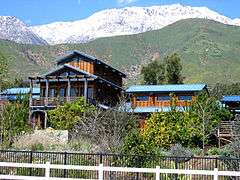
- Sam Maloof Historic Residence and Woodworking Studio – 5131 Carnelian Street (at the northeast corner of the intersection with Hidden Farm Road; 34°09′40″N 117°36′56″W / 34.1610°N 117.6155°W) – historic residence of American woodworker Sam Maloof and now a museum and gardens as well as the office of the Sam and Alfreda Maloof Foundation for Arts and Crafts.
- Henry Albert building / old Alta Loma post office (c. 1906) – 7136 Amethyst Street (at the northwest corner of the intersection with Lomita Drive; 34°07′28″N 117°35′54″W / 34.12441°N 117.59847°W) – now home to Dr. Strange Records.[12]
Structures and monuments
| Name | Date built |
Location | Coordinates |
|---|---|---|---|
| Cherbak House | c. 1921 | 9983 Hillside Rd. (south side of Hillside Rd., between Evening Canyon Way and Briartree Pl.) |
34°09′14″N 117°35′13″W / 34.1539°N 117.5870°W |
| Schowalter House | c. 1913 | 5495 Hermosa Ave. (northeast corner of intersection with Hillside Rd.) |
34°09′16″N 117°35′03″W / 34.1544°N 117.5842°W |
| Schowalter Rock Pile | c. 1913 | North side of Hillside, east of Hermosa | |
| Thorpe House | c. 1916 | 9588 Wilson Ave. (north side of Wilson Ave. between Malachite Ave. and Klusman Ave.) |
34°09′03″N 117°35′47″W / 34.1509°N 117.5963°W |
| G.P. Ledig House | c. 1898 | 5767 Hellman Ave. (southeast corner of intersection with Wilson) |
34°09′00″N 117°36′08″W / 34.1499°N 117.6023°W |
| Warren/Thorpe House | c. 1877 | 6112 Hellman Ave. (southwest corner of intersection with Banyan St.) |
34°08′37″N 117°36′12″W / 34.1435°N 117.6033°W |
| Goerlitz House | c. 1902 | 6156 Hellman Ave. (south of Banyan St.) |
34°08′34″N 117°36′12″W / 34.1427°N 117.6033°W |
| Alta Loma School | c. 1921 | 9480 19th St. (northwest corner of intersection with Amethyst St.) |
34°08′00″N 117°35′48″W / 34.1332°N 117.5967°W |
| Alta Loma Honor Roll | c. 1942 | 6623 Amethyst St. | |
| Ledig House | c. 1895 | 9404 La Vine St. (north side of La Vine St., west of Layton Ct.) |
34°07′35″N 117°36′01″W / 34.1264°N 117.6004°W |
| Alta Loma Heights Citrus Association Packing House (historic location) |
c. 1914 | 7125 Amethyst St. (southeast corner of intersection with La Grande St.; Old structures destroyed. Now senior/low-income apartments.) |
34°07′30″N 117°35′51″W / 34.1249°N 117.5974°W |
| Alta Loma Fire Hall | c. 1938 | 7152 Amethyst St. | |
| Roth's Store/Post Office | c. 1915 | 7157 Amethyst St. (just north of the Pacific Electric Trail) |
34°07′26″N 117°35′53″W / 34.1240°N 117.5980°W |
| Roberds House | c. 1910 | 7201 Amethyst St. (just south of the Pacific Electric Trail) |
34°07′24″N 117°35′51″W / 34.1232°N 117.5974°W |
| Charles Stoebe House | c. 1895 | 6710 Beryl St. (southwest corner of intersection with 19th St.) |
34°07′56″N 117°36′28″W / 34.1322°N 117.6078°W |
Native American ruins
- Like much of the area of the eastern San Gabriel range, Alta Loma's foothills contain artifacts left by the original Native Americans. Some of these were burned and partially destroyed by the Grand Prix Fire in 2003. Many of the ruins sit on land owned by Paul Biane, the current second district supervisor for the San Bernardino County Board of Supervisors and former Rancho Cucamonga councilman.
Schools
Higher education
- Chaffey College – A junior college, serving over 18,000 students in the Inland Empire.[13]
High schools
Junior high schools
- Vineyard Junior High[15]
- Alta Loma Junior High School has won the Presidential Physical Fitness testing nine years in a row.
- Alta Loma Christian School (private)[16]
- Summit Intermediate School
- Etiwanda Intermediate School
- Day Creek Intermediate School
- Cucamonga Middle School
- Rancho Cucamonga Middle School
- Ruth Musser Middle School
Elementary schools
- Alta Loma[15]
- Banyan
- Carnelian
- Deer Canyon
- Floyd M. Stork
- Hermosa
- Jasper
- Victoria Groves
- Alta Loma Christian School (private)[16]
- Terra Vista Elementary School
- Coyote Canyon Elementary School
- Cucamonga Elementary School
- Bear Gulch Elementary School
- Banyan Elementary School
- Valle Vista Elementary School
- Dona Merced Elementary School
- Central Elementary School
- Etiwanda Colony Elementary School
- John L. Golden Elementary School
- Grapeland Elementary School
- Perdew Elementary School
- Windrows Elementary School
- Carlton P. Lightfoot Elementary School
References
- ↑ Hickcox, Robert L.: "Dates in the History of Etiwanda, California"
- ↑ William Bright; Erwin Gustav Gudde (30 November 1998). 1500 California place names: their origin and meaning. University of California Press. p. 14. ISBN 978-0-520-21271-8. Retrieved 20 January 2012. Note, however, that the words are in the wrong order for Spanish, in which it would properly be written as "Loma Alta".
- ↑ Shrieve, Krystn, "Losing Track 1998-1941 Tracing the past; eyeing the future (Turning those old rails into new trails )," Daily Bulletin, Sunday, September 13, 1998
- ↑ Census.gov
- ↑ Dankat.com
- ↑ NationalGeographic.com
- ↑ IncidentControl.com
- ↑ AmericanArt.si.edu
- ↑ Rossi, J.R. "AVG Books written by Flying Tigers". The Flying Tigers - American Volunteer Group - Chinese Air Force.
- ↑ NTHF.org
- ↑ Rancho-Cucamonga.ca.us
- ↑ Solomon, Marcus. "Dr. Strange Interview". Spontaneous Combustion. Retrieved 2013-03-16.
- ↑ "13th Annual / 2012 Report to the Community" (PDF). Chaffey College. October 9, 2012.
- ↑ "Chaffey Joint Union High School District: Schools". Chaffey Joint Union High School District. Retrieved 2013-03-19.
- 1 2 "Alta Loma School District Website". Alta Loma School District. Retrieved 2013-03-19.
- 1 2 "Alta Loma Christian School Website". Alta Loma Christian School. Retrieved 2013-03-19.
- Allen, Robert V. “Peter Demens: the redoubtable hustler.” Quarterly Journal of the Library of Congress 34 (July 1977): 208-26.
- Beattie, George William and Beattie, Helen Pruitt. Heritage of the valley: San Bernardino’s first century. Pasadena: San Pasqual Press, 1939; Biobooks, 1951.
- Black, Esther Boulton. “Early descriptions of Cucamonga and Chino.” Pomona Valley Historian 13 (Winter 1979): 33-6.
- Black, Esther Boulton. “Ranch life in San Antonio Canyon in the 1870s.” Pomona Valley Historian 11 (Spring 1975): 47-58.
- Boyd, James and Brown, John Jr. History of San Bernardino and Riverside counties. 3 volumes. Chicago: Lewis Publishing Co., 1922.
- Clucas, Donald L. “Cucamonga’s ‘lost’ colonies.” Pomona Valley Historian 11 (Summer 1975): 129-38.
- Clucas, Donald L. Light over the mountain: a history of the Cucamonga area. 1974.
- Clucas, Donald L. Light over the mountain: a history of the Rancho Cucamonga area. Revised edition. Upland: California Family House, 1979.
- Conley, Bernice Bedford. Pages from the past. [Ontario?]: [1982].
- Etiwanda Centennial Committee. Etiwanda: [the first] one hundred years. Etiwanda: Etiwanda Centennial Committee, 1982.
- Hickcox, Robert L. A history of Etiwanda. 1981.
- Hickcox, Robert L.; Chaffey High School (1981-09-23). "Dates in the History of Etiwanda, California". Archived from the original on 8 February 2007. Retrieved 2007-01-24.
- Hofer, James D. Cucamonga wines and vines: a history of the Cucamonga Pioneer Vineyard Association. Master’s thesis, Claremont Graduate School, 1983.
- Ingersoll, Luther A. Century Annals of San Bernardino County: 1769 to 1904. Los Angeles: L. A. Ingersoll, 1904.
- Lovitt, Leah J. “The early history of Alta Loma.” Pomona Valley Historian 8 (April 1972): 63-88.
- Martz, Patricia. Description and evaluation of the cultural resources within Cucamonga. . .creek channels. UCARV No. 165. Riverside: Archeological Research Unit, University of California, 1976.
- McCrea, Janet M. History of Chaffey College. B. A. Thesis: California State Polytechnic University, 1971.
- Richards, Betty. “The Chaffeys: saga of a southern California family. Part I.” Pomona Valley Historian 7 (January 1971): 25-46.
- Shrieve, Krystn; Chaffey High School (1998-09-13). "Losing Track 1998-1941 Tracing the past; eyeing the future (Turning those old rails into new trails )". Dailey Bulletin. Archived from the original on 8 February 2007. Retrieved 2007-01-24.
- Sidler, W. A. Floods of the past: an assemblage of documentary observations with particular reference to the San Bernardino Valley and environs. San Bernardino Flood Control District, 1957; enlarged 1972.
- Stoebe, Martha Gaines. The history of Alta Loma, California, 1880-1980. [Rancho Cucamonga]: B and S Publishing Co., 1981.
External links
- LAtimes.com, Los Angeles Times article on Rancho Cucamonga
- Rancho-Cucamonga.ca.us (pdf), Official City of Rancho Cucamonga timeline, October 2003 Grand Prix Fire
- Home.att.net, Personal webpage on Inland Empire history with local maps and bibliographies
- Ranco-Cucamonga.ca.us, Official City of Rancho Cucamonga historical landmarks bike tour