Albia Square and Central Commercial Historic District
|
Albia Square and Central Commercial Historic District | |
|
Historic postcard image of the north side of the town square | |
  | |
| Location | Roughly bounded by the alley of S. and N. Clinton, E. and W. A Ave., N. and S. 2nd St., and E. and W. 2nd Ave., Albia, Iowa |
|---|---|
| Coordinates | 41°01′36″N 92°48′26″W / 41.02667°N 92.80722°WCoordinates: 41°01′36″N 92°48′26″W / 41.02667°N 92.80722°W |
| Architectural style |
Italianate Queen Anne |
| NRHP Reference # | 85000007[1] |
| Added to NRHP | January 3, 1985 |
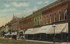
The Albia Square and Central Commercial Historic District encompasses most of the central business district of Albia, Iowa, United States. It was listed on the National Register of Historic Places in 1985. The historic district includes 92 contributing properties from the late 19th and early 20th centuries.[2] A newspaper story that called Albia the ugliest town in Iowa was the catalyst that First Iowa State Bank Board Chairman Robert T. Bates needed to organize in 1965 what became "Operation Facelift." Bates was a renowned interior designer who had worked in Hollywood before returning to Albia in the 1950s.[3] Volunteers solicited a $25 contribution from building and business owners to the Albia Area Improvement Association fund as seed money for the project. Bates himself established a $2,000,000 trust for revitalization efforts in later years.[2]
References
- ↑ National Park Service (2009-03-13). "National Register Information System". National Register of Historic Places. National Park Service.
- 1 2 "Area Information". United Country Real Estate. Retrieved 2016-02-29.
- ↑ "50 years since Operation Facelift". Albia News. Albia, Iowa. August 5, 2015. Retrieved 2016-02-29.
| Topics | |
|---|---|
| Lists by states |
|
| Lists by insular areas | |
| Lists by associated states | |
| Other areas | |
| |
| Albia |  | |
|---|---|---|
| Georgetown | ||
| Lovilia | ||
| Tyrone | ||