Ajmer
| Ajmer अजमेर अजयमेरू | |
|---|---|
| Metropolis | |
|
Mayo College | |
 Ajmer  Ajmer | |
| Coordinates: 26°27′00″N 74°38′24″E / 26.4499°N 74.6399°ECoordinates: 26°27′00″N 74°38′24″E / 26.4499°N 74.6399°E | |
| Country | India |
| State | Rajasthan |
| District | Ajmer |
| Founded by | Raja Ajaypal Chauhan |
| Named for | Raja Ajaypal Chauhan |
| Government | |
| • Body |
District Headquarter Ajmer Ajmer Municipal Corporation (AMC) Ajmer Development Authority (ADA) |
| Elevation | 200 m (700 ft) |
| Population (2011 census) | |
| • Total | 542,580 |
| Languages | |
| • Official | Hindi |
| • Regional | Marwari, English |
| Time zone | IST (UTC+5:30) |
| PIN | 305001 |
| Telephone code | 0145, +91145 |
| Vehicle registration |
RJ-01(Ajmer) RJ-36 (Beawar) RJ-42 (Kishangarh) RJ-48 (Kekri) |
| Nearest city | Jaipur, Udaipur, Jodhpur |
| Website |
www |

Ajmer (pronounced [ədʒmeːr]) is one of the major cities in the Indian state of Rajasthan and is the centre of the eponymous Ajmer District. According to the 2011 census, Ajmer has a population of around 551,360 in its urban agglomeration and 542,580 in the city. The city is located at a distance of 135 km from the state capital Jaipur and 391 km from the national capital New Delhi.
The city was established by a Shakambhari Chahamana (Chauhan) ruler, either Ajayaraja I or Ajayaraja II, and served as the Chahamana capital until the 12th century CE. After the defeat of Prithviraja lll in 1192 CE, the city came under Muslim rule.
Ajmer is surrounded by the Aravalli Mountains. It is a pilgrimage centre for the shrine of the Sufi Saint Khwaja Moinuddin Chishti and is also the base for visiting Pushkar (11 km), an ancient Hindu pilgrimage city, famous for the temple of Brahma. Ajmer has been selected as one of the heritage cities for the HRIDAY - Heritage City Development and Augmentation Yojana scheme of Government of India.[1]
History

Ajmer was originally known as Ajayameru. The 12th century text Prithviraja Vijaya states that the Shakambhari Chahamana (Chauhan) king Ajayaraja II (ruled c. 1110 – 1135 CE) established the city of Ajayameru.[2] Historian Dasharatha Sharma notes that the earliest mention of the city's name occurs in Palha's Pattavali, which was copied in 1113 CE (1170 VS) at Dhara. This suggests that Ajmer was founded sometime before 1113 CE.[3] A prashasti (eulogistic inscription), issued by Vigraharaja IV and found at Adhai Din Ka Jhonpra, states Ajayadeva (that is, Ajayaraja II) moved his residence to Ajmer.[4]
The later text Prabandha-Kosha states that it was the 8th century king Ajayaraja I who commissioned the Ajayameru fort, which later came to be known as the Taragarh fort of Ajmer.[2] According to historian R. B. Singh, this claim appears to be true, as inscriptions dated to the 8th century CE have been found at Ajmer.[5] Singh theorizes that Ajayaraja II later enlarged the town, constructed palaces, and moved the Chahamana capital from Shakambhari to Ajmer.[6]
Climate
| Climate data for Ajmer | |||||||||||||
|---|---|---|---|---|---|---|---|---|---|---|---|---|---|
| Month | Jan | Feb | Mar | Apr | May | Jun | Jul | Aug | Sep | Oct | Nov | Dec | Year |
| Average high °C (°F) | 22.9 (73.2) |
25.7 (78.3) |
31.3 (88.3) |
36.5 (97.7) |
39.7 (103.5) |
38.4 (101.1) |
33.6 (92.5) |
31.3 (88.3) |
32.6 (90.7) |
33.5 (92.3) |
29.2 (84.6) |
24.7 (76.5) |
31.62 (88.92) |
| Average low °C (°F) | 7.6 (45.7) |
10.5 (50.9) |
16.0 (60.8) |
22.2 (72) |
26.8 (80.2) |
27.5 (81.5) |
25.6 (78.1) |
24.4 (75.9) |
23.7 (74.7) |
18.0 (64.4) |
12.3 (54.1) |
8.4 (47.1) |
18.58 (65.45) |
| Average rainfall mm (inches) | 7.3 (0.287) |
6.0 (0.236) |
5.0 (0.197) |
4.0 (0.157) |
15.7 (0.618) |
58.1 (2.287) |
181.5 (7.146) |
157.5 (6.201) |
73.0 (2.874) |
13.1 (0.516) |
4.0 (0.157) |
3.8 (0.15) |
529 (20.826) |
| Source: IMD[7] | |||||||||||||
Ajmer has a hot, semi-arid climate with over 55 centimetres (25.4 in) of rain every year, but most of the rain occurs in the monsoon months, between June and September. Temperatures remain relatively high throughout the year, with the summer months of April to early July having an average daily temperature of about 30 °C (86 °F). During the monsoon there is frequent heavy rain and thunderstorms, but flooding is not a common occurrence. The winter months of November to February are mild and temperate with average temperatures ranging from 15–18 °C (59–64 °F) with little or no humidity. There are, however, occasional cold weather fronts that cause temperatures to fall to near freezing levels.
Transportation

.jpg)
Ajmer is well connected to the major cities of India by land and rail.
Air
Work on the Kishangarh Airport near Ajmer was inaugurated by Prime Minister Manmohan Singh in September 2013 and it is expected to commence operations in 2016.[8] At present the nearest airport is the Jaipur International Airport, about 132 km away, with daily flights to major cities in India.
Tourist sites


- The Ajmer Sharif Dargah: It is a shrine of Khwaja Moinuddin Chishti which is situated at the foot of the Taragarh hill, and consists of several white marble buildings arranged around two courtyards, including a massive gate donated by the Nizam of Hyderabad, and the Akbari Mosque, built by the Mughal emperor Shah Jahan and containing the domed tomb of the saint. Akbar and his queen used to come here by foot every year on pilgrimage from Agra in observance of a vow when he prayed for a son. The large pillars called "Kose ('Mile') Minars", erected at intervals of two miles (3 km) along the entire way between Agra and Ajmer mark the places where the royal pilgrims halted every day.[9] It has been estimated that around 125,000 pilgrims visit the site every day.
- Happy valley (Chashma a Noor)
- Dargah Of Miran Syed Husain: At the highest point of Taragarh fort stands the Dargah of Hazrat Miran Syed Husian Asghar Khangswar who was the governor of Ajmer after its conquest by Sultan Shahabuddin Ghori. On the death of Qutubuddin Aibak in 1210 C.E., the Rathor and Chauhan Rajputs joined in a night attack on the Taragarh Fort when most of the men of Miran Saheb were out collecting taxes in the district, and the number of his garrison was numerically very small. The Rajpurs massacred Miran Saheb and his garrison to a man on 18th Rajab.
- Taragarh Fort: The fort guarding Ajmer, was the seat of the Chauhan rulers and was originally believed to be built by Mughal ruler Akbar.[10] It is reputed to be one of the oldest hill forts in India and the world. It was built by King Ajaypal Chauhan on the summit of Taragarh Hill and overlooks Ajmer. The battlements run along the top of the hill. The walls are two miles (3 km) in circumference and the fort can only be approached by way of a very steep slope. When it fell to the British Raj, the fort was dismantled on the orders of Lord William Bentinck and was converted into a sanatorium for the British troops stationed at the garrison town of Nasirabad.[9]
- Adhai Din Ka Jhonpda: A mosque by Qutubuddin Aibak built in 1193, is situated on the lower slope of Taragarh hill. Aibak's successor, Shams al-Din Iltutmish added to the mosque. It is noted for its double-depth calligraphy inscriptions in the Naskh and Kufic scripts. Apart from the mosque, called Jama Iltutmish (pronounced Altamash locally), nearly the whole of the ancient temple has fallen into ruins, but the relics are still unsurpassed as examples of Hindu architecture and sculpture. Forty columns support the roof, but no two are alike and the ornaments are exceptional in their decorations.[11][9]
- Akbari Fort & Museum : The city's museum, was once the residence of Prince Salīm, the son of the Emperor Akbar, and presently houses a collection of Mughal and Rajput armour and sculpture. This is a magnificent example of Mughal architecture, construction of which was commissioned by Akbar in 1570. This is where Salim, as the Emperor Jahangir, read out the firman permitting the British East India Company to trade with India.[12]
- Maqbara Shaikh Husain: It houses the tomb of Khwaja Husain Chishty Rehamatullah Alaih (Shaikh Husain Ajmeri) who was the Peer of Ajmer Sharif Dargah in Emperor Akbar's Time. He was the great grandson of Khwaja Moinuddin Hasan Chishty Rehmatullah Alaih, his tomb was built in 1637–1638 by Khwaja Alauddin Chishty and Sajjadanashin Hazrat Khwaja Moinuddin.
- Mayo College: The college was founded in 1875 by Lord Mayo, Viceroy of India. The architecture of the buildings is in the same style as royal Rajasthani architecture. The main building, in white marble, is a classic example of Indo-Saracenic architecture.[13]
Ajmer Sightseeing:[14]
- Anasagar Lake: This is an historic man-made lake built by Maharaja Anaji (1135–1150 AD).[10] By the lake is the Daulat Bagh, a garden laid out by Emperor Jahangir. Emperor Shah Jahan later added five pavilions, known as the Baradari, between the garden and the lake.
- The Sai Baba Temple: located on the way to the Prithviraj Chauhan Statue, this temple is also an important tourist destination which has the same style of architecture as that of the Sai Baba Temple in Shirdi.
- Soniji Ki Nasiyan: It is an architecturally rich Digambara Jain temple. It was built in the late nineteenth century. The main chamber, known as the Swarna Nagari "City of Gold", has several gold-plated wooden figures, depicting figures in the Jain religion.[15] it has a gold model of the city of Ayodhya, the birthplace of Ram.
 Lord Ram (at centre)
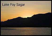
 - Lake Foy Sagar: It is situated in the outskirts of the city, it is a picturesque artificial lake that was created as a famine relief project in 1892. It offers panoramic views of the neighbouring Aravalli mountains as well as of the evening flights of nearby birds.
- Nareli Jain Temple: It is a relatively new Jain temple. It is located on the outskirts of Ajmer and lies on the national highway NH8.[16]
- Located about 11 kilometres from Ajmer, Pushkar is also an important tourist destination. It is famous for Pushkar Lake and the 14th century Brahma Temple at Pushkar, dedicated to Brahmā, according to the Padma Purāņa, Pushkar is the only place where Brahmā may be worshipped.[17]

Demographics
| Population Growth of Ajmer | |||
|---|---|---|---|
| Census | Pop. | %± | |
| 1891 | 68,800 | — | |
| 1901 | 73,800 | 7.3% | |
| 1911 | 86,200 | 16.8% | |
| 1921 | 113,200 | 31.3% | |
| 1931 | 119,500 | 5.6% | |
| 1941 | 147,300 | 23.3% | |
| 1951 | 196,300 | 33.3% | |
| 1961 | 231,200 | 17.8% | |
| 1971 | 264,300 | 14.3% | |
| 1981 | 374,400 | 41.7% | |
| 1991 | 402,700 | 7.6% | |
| 2001 | 490,520 | 21.8% | |
| 2011 | 551,101 | 12.4% | |
| source:[18] | |||
| Year | Population |
|---|---|
| 1891 | 68,800 |
| 1901 | 73,800 |
| 1911 | 86,200 |
| 1921 | 113,200 |
| 1931 | 119,500 |
| 1941 | 147,300 |
| 1951 | 196,300 |
| 1961 | 231,200 |
| 1968 | 265,200 |
| 1971 | 264,300 |
| 1981 | 374,400 |
| 1991 | 402,700 |
| 2001 | 490,520 |
| 2011 | 551,101 |
Source:[18]
According to the 2011 India census,[19] Ajmer district has a population of 2,584,913, which was made up of 1,325,911 males and 1,259,002 females. Ajmer district had an average literacy rate of 70.46%, male literacy being 83.93% and female literacy 56.42%. There was a total of 1,557,264 literates compared to 1,168,856 in the 2001 census. The population density in Ajmer district was 305 compared to 257 per km2 in 2001. The female to male ratio in Ajmer was 950/1,000. This represents an increase of 2.04% from the 2001 census. Ajmer's population growth in the decade was 18.48%, this compares to a growth figure of 20.93% for the previous decade. The population of Ajmer city according census 2011 is 542,580 positioning Ajmer in top 100 major cities of India and 5th in Rajasthan.
See also
References
- ↑ "Introduction". Hriday official website.
- 1 2 R. B. Singh 1964, p. 87.
- ↑ Dasharatha Sharma 1959, p. 40.
- ↑ Har Bilas Sarda 1911, pp. 68-74.
- ↑ R. B. Singh 1964, p. 88.
- ↑ R. B. Singh 1964, pp. 131-132.
- ↑ "Monthly mean maximum and minimum temperature and total rainfall of important cities (PDF)" (PDF). Retrieved 2013-07-28.
- ↑ "Focus on connecting small cities by air: Manmohan". The Hindu. 21 September 2013. Retrieved 2013-10-02.
- 1 2 3
 One or more of the preceding sentences incorporates text from a publication now in the public domain: Chisholm, Hugh, ed. (1911). "Ajmere". Encyclopædia Britannica. 1 (11th ed.). Cambridge University Press. pp. 452–453.
 - 1 2 Gopal, Madan (1990). K.S. Gautam, ed. India through the ages. Publication Division, Ministry of Information and Broadcasting, Government of India. p. 173.
- ↑ Arhai-din-ka Jhompra Mosque archnet.org.
- ↑ "Akbar Ka Kila , AJMER".
- ↑ Main Building Architecture: Official website of Mayo College, Ajmer, India
- ↑ Ajmer Sightseeing
- ↑ "Magazine | Jain Culture | Temples | India | Rajasthan ►Ajmer ►Soniji Ki Nasiyan". Herenow4u.net. Retrieved 2012-05-18.
- ↑ "Sight Seeing". Ajmer.nic.in. Retrieved 2012-05-19.
- ↑ News India Times, New York NY, USA, April 25, 2008.
- 1 2 "Historical Census of India".
- ↑ "Census of India 2001: Data from the 2001 Census, including cities, villages and towns (Provisional)". Census Commission of India. Archived from the original on 2004-06-16. Retrieved 2008-11-01.
Bibliography
- Dasharatha Sharma (1959). Early Chauhān Dynasties. S. Chand / Motilal Banarsidass. ISBN 9780842606189.
- Har Bilas Sarda (1911). "Adhai-Din-ka-Jhonpra". Ajmer: Historical and Descriptive (PDF). Scottish Mission.
- R. B. Singh (1964). History of the Chāhamānas. N. Kishore. OCLC 11038728.
- W.D. Begg: The Holy Biography of Hazrat Khwaja Muinuddin Chishti (Millat Book Centre, Delhi, 1999).
- Ajmer The Imperial Gazetteer of India, 1909, v. 5, p. 137-146.
External links
| Wikivoyage has a travel guide for Ajmer. |
| Wikimedia Commons has media related to Ajmer. |
- Ajmer District website
- R. Nath Mughal Architecture Image Collection, Images from Ajmer - University of Washington Digital Collection
| Outline |  | ||||||||||||||||||||||||||
|---|---|---|---|---|---|---|---|---|---|---|---|---|---|---|---|---|---|---|---|---|---|---|---|---|---|---|---|
| Governance | |||||||||||||||||||||||||||
| Divisions and Districts |
| ||||||||||||||||||||||||||
| Major cities | |||||||||||||||||||||||||||
| Related templates |
| ||||||||||||||||||||||||||