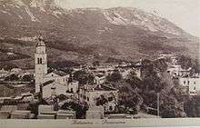
Ajdovščina
| Ajdovščina | |
|---|---|
|
Ajdovščina | |
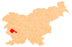
 Ajdovščina Location in Slovenia | |
| Coordinates: 45°53′14.6″N 13°54′5.2″E / 45.887389°N 13.901444°ECoordinates: 45°53′14.6″N 13°54′5.2″E / 45.887389°N 13.901444°E | |
| Country |
|
| Traditional region | Littoral |
| Statistical region | Gorizia |
| Municipality | Ajdovščina |
| Area | |
| • Total | 7.0 km2 (2.7 sq mi) |
| Elevation[1] | 106 m (348 ft) |
| Population (2012) | |
| • Total | 6,676 |
| • Density | 960/km2 (2,500/sq mi) |
| Climate | Cfa |
| Website | [2] |

Ajdovščina (pronounced [ˈaːi̯dɔu̯ʃtʃina]; Italian: Aidussina,[3] German: Haidenschaft) is a small town with a population of about 6,700, located in the Vipava Valley (Vipavska dolina), Slovenia.[4] It is the administrative centre of the Municipality of Ajdovščina.
History

The first mentions of Ajdovščina go back to circa 2000 BC. In the Bronze Age and the Iron Age a fortified settlement stood on the nearby hill of Gradišče. In the early period of the Roman Empire, after a road was built from Aquileia towards Emona, a small post and goods station known as mansio Fluvio Frigido stood on the site of today's Ajdovščina.[5]
In the late 3rd century and the early 4th century a fortification system, Claustra Alpium Iuliarum, which run from the Kvarner Gulf to Cividale, was built by the Roman Empire. Its centre was the fortress of Castra or Castrum ad Fluvio Frigido, the remains of which are today still visible in Ajdovščina.[5]
Despite the fact that the Italian border is less than 20 km away and that Ajdovščina was under Italian administration from 1918 to 1947, and from 1927 as a commune of the Province of Gorizia (as Aidussina), during Italian rule (1918–1943, nominally lasted to 1947),[6] the style of the town does not resemble that of a typical Italian town. The strong bora winds would cause damage to the usual Italian house construction. Thus the population adopted and modified the classical Karst architecture for their own needs; for example, by putting stones on roofs to weight down the tiles against the strong winds.
After World War II Ajdovščina became the economic and cultural centre of the upper Vipava Valley. Major industries include textile fabrics, construction, food, beverages, and furniture.
Ajdovščina annexed the formerly independent settlement of Šturje (Italian: Sturie delle Fusine) in 1953.[7]
Geography and climate
The Hubelj River is the dividing line between the two largest parts of Ajdovščina, locally known as Šturje and Ajdovščina. During the pre-World War I years the river was also the border between the Austrian lands of Gorizia and Gradisca and Carniola.
The climate is Mediterranean (minimum temperature in winter −1 °C (30 °F), maximum 17 °C (63 °F); in the summer time maximum temperature 39 °C (102 °F), minimum 20 °C (68 °F). The town is located around 25 km from the Adriatic Sea.
Landmarks
Churches
.jpg)
The parish church in Ajdovščina is dedicated to John the Baptist and belongs to the Diocese of Koper.[8] It is built on the site of a Roman cemetery. Its interior was painted by the local Baroque painter Anton Čebej.[9] A second parish within the urban area of Ajdovščina is the Parish of Šturje, with the parish church dedicated to Saint George. The church in the hamlet of Fužine north of the main town, dedicated to Saint Anthony of Padua, also belongs to this parish.[10]
Notable residents
- Ivo Boscarol (born 1957), businessman
- Anton Čebej (1722–1774), painter
- Miša Cigoj (born 1982), dancesport athlete
- Milan Klemenčič (1875–1957), puppeteer
- Karel Lavrič (1818–1876), politician
- Danilo Lokar (1892–1989), author
- Julij Mayer (1891–1983), beekeeper[11]
- Veno Pilon (1896–1970), painter
- Avgust Žigon (1877–1941), literary historian
See also
References
- ↑ "Nadmorska višina naselij, kjer so sedeži občin" [Height above sea level of seats of municipalities] (in Slovenian). Statistical Office of the Republic of Slovenia. 2002.
- ↑ "Ajdovščina, Ajdovščina". Place Names. Statistical Office of the Republic of Slovenia. Retrieved 21 February 2013.
- ↑ trilingual name "Haidenschaft, Aidussina, Ajdovščina" in: Gemeindelexikon, der im Reichsrate Vertretenen Königreiche und Länder. Bearbeit auf Grund der Ergebnisse der Volkszählung vom 31. Dezember 1900. Herausgegeben von der K.K. Statistischen Zentralkommission. VII. Österreichisch-Illyrisches Küstenland (Triest, Görz aund Gradiska, Istrien). Wien 1906
- ↑ Ajdovščina municipal site
- 1 2 Pavlin, Primož. "Poznoantična utrdba Kastra (Ajdovščina)" [The Late-Antique Fortification of Castra (Ajdovščina)]. DEDI - enciklopedija naravne in kulturne dediščine na Slovenskem (in Slovenian). Retrieved 8 April 2014.
- ↑ http://utenti.multimania.it/Legionario/vgammin.htm Ajdovščina was during Italian Rule
- ↑ Spremembe naselij 1948–95. 1996. Database. Ljubljana: Geografski inštitut ZRC SAZU, DZS.
- ↑ Koper Diocese list of churches
- ↑ Slovenian Tourist Board site
- ↑ Šturje parish site
- ↑ Bokal, Ljudmila, ed. 2008. Čebelarski terminološki slovar. Ljubljana: Založba ZRC, ZRC SAZU and Lukovica: Čebelarska zveza Slovenije, p. 255.
External links
| Wikimedia Commons has media related to Ajdovščina. |
- Ajdovščina municipal page (Slovene)]
- Ajdovščina on Geopedia
- Ajdovščina Tourist Information Centre site
- Virtual Ajdovščina by Burger (virtual photos)
| Settlements | Administrative centre: Ajdovščina
|  | ||||||
|---|---|---|---|---|---|---|---|---|
| Landmarks |
| |||||||
| Notable people |
| |||||||