Ajapnyak District
Coordinates: 40°11′57″N 44°28′14″E / 40.19917°N 44.47056°E
| Ajapnyak Աջափնյակ | |
|---|---|
|
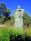
Ajapnyak district and the statue of Kevork Chavush | |
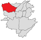 Ajapnyak district shown in red | |
| Country | Armenia |
| Marz (Province) | Yerevan |
| Government | |
| • Mayor of District | Artavazd Sargsyan[1] |
| Area | |
| • Total | 25 km2 (10 sq mi) |
| Population (2011 census) | |
| • Total | 108,282 |
| • Density | 4,300/km2 (11,000/sq mi) |
| Time zone | AMT (UTC+4) |

Ajapnyak (Armenian: Աջափնյակ), is one of the 12 districts of Yerevan, the capital of Armenia. It is located to the northwest of the city centre. As of the 2011 census, the district has a population of 108,282.
Its name, literally "right bank", refers to its location on the right bank of Hrazdan River. The administrative district of Ajapnyak has common borders with the districts of Arabkir, Davtashen, Kentron, and Malatia-Sebastia. On the outer border it is adjacent to Armavir, Aragatsotn and Kotayk provinces.[2]
The district lies on the right bank of Hrazdan River, thus securing its connection with the rest of Yerevan through the Great Bridge of Hrazdan. It is unofficially divided into smaller neighborhoods such as: Ajapnyak neighbourhood, Norashen, Nazarbekyan, Silikyan, Lukashin, Vahagni, Anastasavan and Cheremushki.
The district is home to the Armenia Republican Medical Centre, the largest hospital in Yerevan. The "Shant" ice cream factory is located in Ajapnyak as well.
Streets and landmarks
Main streets
- Kevork Chavush street.
- Halabyan street.
- Zovuni street.
- Movses Silikyan old highway.
- Movses Silikyan new highway.
- Ashtarak Highway.
- Leningradyan street.
Landmarks

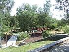
- Tumanyan Park.
- Buenos Aires Park.
- Liberators' Park.
- Tumo Center for Creative Technologies.
- Yerevan Physics Institute.
- Ararat Golf and Country Club: located at the Vahagni neighbourhood of Ajapnyak district.
Gallery
- Ajapnyak district
-
.jpg)
Ajapnyak district as seen from the Tumanyan park
-

New buildings in the district
-
The sculpture of Anush and Saro at the Tumanyan Park

References
City of Yerevan | |||
|---|---|---|---|