Aharbal
| Aharbal | |
|---|---|
| Hill station | |
|
Aharbal Falls | |
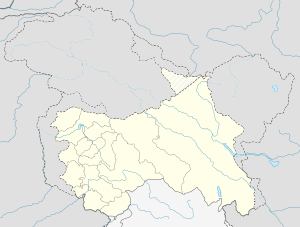 Aharbal  Aharbal Location in Jammu and Kashmir, India | |
| Coordinates: 33°38′45.4560″N 74°46′50.4696″E / 33.645960000°N 74.780686000°ECoordinates: 33°38′45.4560″N 74°46′50.4696″E / 33.645960000°N 74.780686000°E | |
| Country | India |
| State | Jammu and Kashmir |
| District | Kulgam |
| Elevation | 2,266 m (7,434 ft) |
| Languages | |
| • Official | Urdu |
| Time zone | IST (UTC+5:30) |
Aharbal is a hill station in the south-western part of Kashmir Valley in the Indian state of Jammu and Kashmir, 75 km south of the state capital Srinagar.[1]
Geography
Aharbal lies in the Kulgam district[2] of Jammu and Kashmir. It is located on the Veshu River, a tributary of the Jehlum River, in an alpine valley covered in pine and fir trees within the Pir Panjal mountains, 18 km south of the town of Shopian and 28 km west of Kulgam. It lies at an altitude of 2266 metres above sea level.[3][4][5]
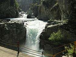
Aharbal Falls
Aharbal is known for its waterfall, Aharbal Falls, where the Veshu falls noisily 25 metres and 7 metres through a narrow gorge of granite boulders. Aharbal Falls are also referred to as the Niagara Falls of Kashmir, owing to the volume of the water that falls. According to a report, the water volume would be sufficient to generate 100 MW of hydroelectricity. The terraces leading to the falls are fenced, but care must be taken to avoid slipping.[3][6][7][8]
Tourism
Aharbal is a base for adventure tourism. The Veshu River is stocked with trout. The fishing permit can be obtained from the Fisheries department stationed at Aharbal. The alpine meadow of Kungwatan lies at the halfway point of the two-day trek to the high-altitude Konsernag Lake, which is the source of the Veshu. Other activities include horse riding, photography, and skiing during winter. The Aharbal Development Authority, a government agency responsible for development in Aharbal, has built tourist infrastructure including huts and a cafeteria, and other lodging and boarding facilities have also been made available.[9][10][11]
Access
Aharbal is easily accessible from Srinagar, only 8 km from the Mughal Road that connects Srinagar and Poonch. The 75 km drive takes less than 3 hours by car or bus via Pulwama and Shopian. An alternate route leads to Aharbal via Kulgam. The nearest railway station is Awantipora railway station at 26 km in the east.[4][12][13]
See also
References
- ↑ "Hill stations in Kashmir". hillstations. Retrieved 2012-11-26.
- ↑ "Aharbal in district Kulgam" (pdf). Retrieved 2013-06-20.
- 1 2 Allan Stacey (1988). Visiting Kashmir. Hippocrene Books, 1988. p. 129. ISBN 978-0-87052-568-1. Retrieved 27 November 2012.
- 1 2 "Aharbal Waterfalls". indiatourisminfo.net. Retrieved 2012-11-26.
- ↑ Ishtiaq Ahmad Mayer (2007). Medical Geography. APH Publishing, 2007. p. 60. ISBN 978-813130268-2. Retrieved 27 November 2012.
- ↑ "Niagara falls of Kashmir". greaterkashmir. Archived from the original on 2013-07-28. Retrieved 2012-11-26.
- ↑ "Tourist spots JK Tourism". economictimes. Retrieved 2012-11-27.
- ↑ "Girl jumps into Aharbal Falls". kashmirimages.com. Retrieved 2012-11-26.
- ↑ Dr. Shiv Sharma (2008). India: A Travel Guide. Diamond Pocket Books. p. 199–. ISBN 978-812840067-4. Retrieved 26 November 2012.
- ↑ Treks, Kashmir. "Aharbal-Kounsarnag Trek". KashmirTreks.in. Retrieved 5 August 2013.
- ↑ "Aharbal waterfall in JK to get facelift". IBNLive. Retrieved 2012-11-27.
- ↑ "Aharbal travel". onefivenine. Retrieved 2012-11-26.
- ↑ M.S. Kohli (1983). Himalayas: Playground of the Gods -Trekking, Climbing and Adventure. Indus Publishing. pp. 40–42–. ISBN 978-817387107-8. Retrieved 27 November 2012.
External links
| Aharbal Waterfall | |
|
|