Abbot Pass
| Abbot Pass | |
|---|---|
|
Abbot Pass, with the approach from the British Columbia side | |
| Elevation | 2,925 m (9,596 ft) |
| Location | Banff National Park, Alberta / Yoho National Park, British Columbia, Canada |
| Range | Canadian Rockies |
| Coordinates | 51°21′50″N 116°17′14″W / 51.36389°N 116.28722°WCoordinates: 51°21′50″N 116°17′14″W / 51.36389°N 116.28722°W |
| Topo map | NAD 83/11U |
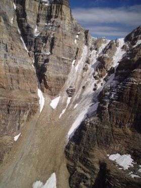
Abbot Pass lies between Mount Lefroy and Mount Victoria, in the divide between the valleys of Lake O'Hara and Lake Louise.[1] It was named for Phillip Stanley Abbot who died in 1896 in an attempt to climb Mount Lefroy with Charles Fay, Charles Thompson, and George T. Little.[2]
Abbot Pass has a stone hut, built in 1922 by Swiss guides working for the Canadian Pacific Railway, now maintained by the Alpine Club of Canada.
References
- ↑ "Abbot Pass". BC Geographical Names.
- ↑ National Historic Sites Archived January 17, 2007, at the Wayback Machine. page at Parks Canada, retrieved 2006-08-27
This article is issued from Wikipedia - version of the 11/13/2016. The text is available under the Creative Commons Attribution/Share Alike but additional terms may apply for the media files.