A9 motorway (Switzerland)
| |
|---|---|
|
Location of the A9 in Switzerland | |
| Route information | |
| Length: | 230 km (140 mi) |
| Major junctions | |
| From: | French border |
| To: | Italian border |
| Highway system | |
| Motorways of Switzerland | |
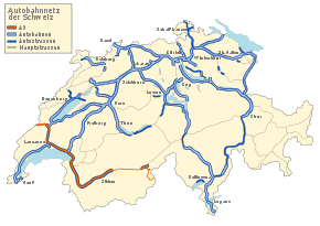
The A9 motorway, an Autobahn in western Switzerland, is a divided highway connecting from Ballaigues (in northwest) to southwestern Switzerland.[1] It is part of the National Road N9.[2]
It is double-tracked as a divided highway (directionally separated) in most sections. The N9/A9 runs from Ballaigues on the French border via Vevey, Sion, Brig on the Simplon Pass up to Gondo on the Italian border. The line Sierre-Gamsen is still under construction and not passable. The construction of this 31-kilometre (19 mi) line will cost 2270 million CHF: it is funded at 4% by the Canton of Valais and at 96% by the Swiss federal government.
Major engineering works
The following are major construction projects underway along A9:
- Sierre-Gamsen-VS line
Junction list
| Junctions | ||||||||||||||||||||||||||||||||||||||||||||||||||||||||||||||||||||||||||||||||||||||||||||||||||||||||||||||||||||||||||||||||||||||||||||||||||||||||||||||||||||||||||||||||||||||||||||||||||||||||||||||||||||||||||||||||||||||||||||||||||
| ||||||||||||||||||||||||||||||||||||||||||||||||||||||||||||||||||||||||||||||||||||||||||||||||||||||||||||||||||||||||||||||||||||||||||||||||||||||||||||||||||||||||||||||||||||||||||||||||||||||||||||||||||||||||||||||||||||||||||||||||||
Notes
- ↑ "Die Schweitzer Autobahnen", web: Autobahnen.ch
- ↑ "Rhone-Autobahn A9", 2009, web: Rhone-Autobahn A9.
References
- "Die Schweizer Autobahnen", Autobahnen.ch, 2009, web: Autobahnen.ch (with sub-webpage for A9).
- More sources in "Motorways of Switzerland".
External links
- Rhone-Autobahn A9
- Photo-series A9 on Autobahnen.ch
- Project Brig-Gondo (Simplon)
- Project Bex-Martigny
- Project Schwerverkehrskontrollzentrum St. Maurice (traffic-control center)
Motorways of Switzerland ( Autobahnen / Autoroutes / Autostrade ) | |||
|---|---|---|---|
Coordinates: 46°25′33″N 6°55′48″E / 46.425833°N 6.929884°E