List of roads in the Isle of Man
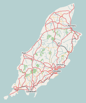
Overview map of roads in the Isle of Man.
List of roads on the Isle of Man.
- This transport-related list is incomplete; you can help by expanding it.
"A" roads
| Road | From | To | Notes | Coordinates | Route Map |
|---|---|---|---|---|---|
| |
Douglas |
Peel | Including the A1 Peel Road joining the A2 and A5 roads at the Quarterbridge and the A3 road at Ballacraine. Connects Douglas on the east of the island with Peel on the west. In Douglas the road is known as Peel road and in Peel as Douglas road. Between Douglas and Peel, the road passes through Union Mills, Crosby and St John's. | 54°11′32″N 4°35′11″W / 54.19232°N 4.58637°W | .png) Route of the A1 road. |
| |
Douglas |
Ramsey | Connects Douglas on the east of the island with Ramsey in the north. Between Douglas and Ramsey, the road travels along the east coast of the island and passes through Laxey at the midpoint. | 54°14′44″N 4°22′22″W / 54.24542°N 4.3729°W | .png) Route of the A2 road. |
| |
Castletown |
Ramsey | Connects Castletown in the south of the island with Ramsey in the north. Between Castletown and Ramsey, the road passes through Foxdale, St John's, Kirk Michael and Sulby. Between Ballacraine and Ramsey, the road forms part of the Snaefell Mountain Course over which the Isle of Man TT races are held each year. | 54°14′39″N 4°36′05″W / 54.24421°N 4.60147°W | .png) Route of the A3 road. |
| |
Peel |
Kirk Michael | Connects Peel with Kirk Michael on the west coast of the island. | 54°15′15″N 4°37′49″W / 54.25429°N 4.63039°W | |
| |
Douglas |
Port Erin | Also called New Castletown Road; connects Douglas in the east of the island with Port Erin in the south via Richmond Hill. Between Douglas and Port Erin, the road passes through Santon, Ballasalla and Castletown before travelling along Gansey Bay and past the northern side of Port St Mary. Between Santon and Ballasalla, the road passes over the Fairy Bridge. | 54°07′13″N 4°35′01″W / 54.12015°N 4.58353°W | .png) Route of the A5 road. |
| |
Douglas |
Cronk-ny-Mona | Also called Kewaigue Road. A short road connecting Douglas with the A5 (Douglas to Port Erin) road at the southeastern extent of the town. The road passes through the small settlement of Kewaigue. | 54°07′25″N 4°32′55″W / 54.12372°N 4.5486°W | |
| |
Ballasalla |
Port Erin | Connects Ballasalla with Port Erin in the south of the island. Between Ballasalla and Port Erin, the road crosses the A3 (Castletown to Ramsey) road and passes through Ballabeg and Colby. | Coordinates: 54°05′56″N 4°41′06″W / 54.09902°N 4.68506°W | |
| |
Ramsey |
Andreas | |||
| |
Ballaugh |
Ramsey | |||
| |
Douglas |
Balladromma Beg | Also known as King Edward VIII Road. | ||
| |
Castletown |
Derbyhaven | |||
| |
Ramsey |
Jurby | |||
| |
Jurby |
Bungalow | |||
| |
Bride |
Point of Ayre | |||
| |
Port Lewaigue (Belle Vue) |
The Hiberian | Maughold Road | ||
| |
Bride |
Andreas | |||
| |
Douglas |
Ramsey | Snaefell Mountain Road. The entire road forms part of the Isle of Man TT Course and crosses the hilliest parts of the island reaching 422 m (1,385 ft). The road is closed for TT and Manx Grand Prix races and sometimes closed due to bad weather at other times. The majority of the road outside of developed areas has no speed limit. See A18 for more about this road. | .png) Route of the A18 road. | |
| |
Lhen Bridge |
Andreas | |||
| |
Peel |
Ballig | Also known as Poortown Road, after the small settlement of Poortown through which it passes. Connects Peel on the west coast of the island with the A3 (Castletown to Ramsey) road at a point just north of St John's. | 54°12′58″N 4°39′48″W / 54.21607°N 4.66344°W | |
| |
Union Mills |
St Ninian's Crossroads | |||
| |
Strang |
Crosby | |||
| |
Douglas |
Foxdale | Connects the A3 (Castletown to Ramsey) road in Foxdale with A5 (Port Erin to Douglas) road. Between Foxdale and Douglas, the road passes the Eairy Dam and Braaid. | 54°09′27″N 4°35′07″W / 54.15746°N 4.58524°W | |
| |
Douglas |
Blackboards | Also known as Old Castletown Road. Connects Douglas with Ballasalla, and historically Castletown. The road is now bypassed by the A5 Douglas to Port Erin route which allows for faster traffic movement. | 54°07′44″N 4°32′28″W / 54.12875°N 4.54113°W | |
| |
Ballasalla |
Glen Vine | Connects Ballasalla with Glen Vine where it meets the A1 (Douglas to Peel) road. Between Ballasalla and Glen Vine, the road passes through St Mark's and Braaid. | 54°08′44″N 4°35′29″W / 54.14544°N 4.59142°W | |
| |
Colby |
Peel | Also known as Colby Glen Road. Connects Colby with Peel. Between its junction with the A7 road in Colby and its terminus in the centre of Peel, the road passes through Colby Glen, the Round Table, Dalby, Glenmaye and Patrick. | 54°09′21″N 4°42′32″W / 54.15595°N 4.70875°W | |
| |
Ballakaighan, Castletown |
Ballabeg, Arbory | |||
| |
St John's |
Patrick | 54°12′11″N 4°39′53″W / 54.20317°N 4.66481°W | ||
| |
Port St Mary |
Calf Sound | Also known as Raad yn Cheyllys. Connects Port St Mary with the Calf Sound, the most southerly point of the island. Between Port St Mary and the Sound, the road passes the village of Cregneash. | 54°04′25″N 4°45′34″W / 54.07349°N 4.7594°W | |
| |
Port Erin |
Ballachurry, Port Erin | |||
| |
Ballanank, Malew |
Mount Rule, Malew | Also known as Phildraw Road; connects Ballasalla with the A3 (Castletown to Ramsey) road. | 54°06′35″N 4°37′48″W / 54.10959°N 4.63005°W | |
| |
Port Erin |
South Barrule | Connects the A7 (Ballasalla to Port Erin) road near Port Erin to the A3 (Castletown to Ramsey) road south of Foxdale. The road is known as the Sloc Road as it bends through the Sloc, a pass on the southern side of Cronk ny Arrey Laa. It is also known as the Shoulder road as it passes over the northern shoulder of South Barrule. | 54°07′51″N 4°42′56″W / 54.13096°N 4.71545°W | |
| |
Douglas |
Port Soderick | Also known as Marine Drive. | ||
| |
|||||
| |
The Hope |
St John's | Connects the A3 (Castletown to Ramsey) road at the Hope (near Foxdale) with the A1 (Douglas to Peel) road at Tynwald Hill in St John's. | 54°11′56″N 4°38′25″W / 54.19895°N 4.64018°W |
| Wikimedia Commons has media related to A roads in the Isle of Man. |
"B" roads
- B3 Kerrowmoar to Jurby road / Jurby East road
- B4 Ballaheaney road
- B5 Ballavarran road
- B6 Smeale road
- B7 Kerrowgarrow to Regaby road
- B8 Sulby Claddagh road
- B9 Ballacrye road
- B10 Brandywell Road/Sartfield Road
- B11 Ballaragh road
- B12 Creg Ny Baa Back Road
- B13 East Bretney Road
- B14 Bernahara road
- B15 Richmond road, Ramsey
- B17 Lezayre Church road
- B19 Dreemskerry road
- B20 Begoade road
- B21 East Baldwin road
- B22 West Baldwin Road
- B23 Port Soderick Road
- B24 Oatland road
- B25 Ballavale road, Santon
- B26 Ballavale road, Santon
- B29 Ballachurry / Ballacharry road
- B30 Ballamodha to St Marks road (The Bayrauyr)
- B32 Lhergy Cripperty road
- B33 Croit-e-Caley / Kentraugh Mill road
- B35 Garth road
- B36 Tosaby road
- B37 Clannagh road
- B38 Orrisdale road
- B39 Ronague Road/Solomons Corner to Corlea road
- B40 Ballamaddrell / Grenaby road
- B41 Grenaby to Kerrowkeill Road
- B42 Ronague Road
- B43 Ballagawne road
- B44 Ballakilpheric road
- B45 Mount Gawne road
- B46 Barracks road, Rushen
- B49 Laxey Promenade
- B50 Silverdale road
- B52 Keristal road
"C" roads
- C3 Switchback road
- C4 Ballaleigh road
- C5 Ballabooie road
- C6 Thurot Cottage road
- C7 Rhendoo road
- C8 Garey road
- C9 Ballamodda road
- C10 Scholag road
- C11 Ellerslie road
- C12 Rushen Abbey road
- C13 Jacks Lane, Lewaigue to Port-e-Vullen road
- C14 Ballacorey road
- C15 Dogmills to Regaby road
- C16 Tynwald Hill road
- C17 Gleneedle Road
- C19 Orrisdale road
- C20 Mullinaragher road
- C21 Mount Murray Back road
- C22 Little Mill road
- C24 Kentraugh Back road
- C25 Staarvey road
- C26 Ballagawne road
- C27 Port Cornaa road
- C28 Killane road
- C29 Old Windmill road
- C30 Ballaterson road
- C31 Dollagh Mooar road
- C32 Glen Vine road
- C33 Archallagan road
- C34 Ballavar and Lhoobs road
- C35 Kionslieu road
- C36 Grenaby road
- C37 Druidale road
- C40 Glen Rushen road
"D" roads
- D3 Ballaghennie / Baldhoon road
- D4 Ballakinnag road
- D5 Blue Point road
- D7 West Craig Loop road
- D8 Pond road
- D10 Skyhill road
- D11 Narradale road
- D12 Old Church road
- D13 Bollyn road
- D18 Stockfield road
- D19 Little London Road
- D20 Ballagyr road
- D21 Brack-a-Broom road
- D23 Rhenab / Cornaa road
- D24 Ballaberna road
- D26 Quakers road
- D29 Lower Glen Mona road
- D30 Lower Dhoon road
- D31 Baldhoon road, Laxey
- D33 Ballamenaugh road
- D34 Bibaloe Beg / Eskadale road
- D37 Garey road
- D38 Rhyne road
- D44 Fort Island road / causeway
- D45 Poyllvaaish road
- D46 Chibbyr Pheric road
- D47 Garey road
- D48 Niarbyl road, Dalby
- D55 Ballachurry road
- D58 Whallag road (Whisky Run)
- D60 Dalby Lhag road
- D61 Lhergydhoo Farm road
- D65 Upper Rencell Hill
- D66 Eairy Kelly road
- D68 Eairy Cushlin road
- D72 Maughold Lighthouse road
- D76 Lhergydhoo road
"U" roads
- U7 Old Sulby road
- U8 West Kella road
- U9 Ballacaley road
- U16 Ballacob / Slieau Curn road
- U21 Clarum road
- U31 Nobles Park road
- U36 Balladhoo road
- U39 Garey road
- U46 Ballacorris road
- U53 Stoney Mountain road
- U54 Sound road
- U55 Kennaa road
- U60 Rock road
- U62 Balnahowe road
- U67 Moaney road
- U69 Governor Loch’s road
- U77 Rullick road
- U83 Ballaugh Plantation / Cronagh road
- U90 Snaefell Mines road
- U92 Maughold Mountain road
- U93 Ohio road
- U94 Ballabrooie road
- U100 Druidale road
See also
Sources
External links
This article is issued from Wikipedia - version of the 11/25/2016. The text is available under the Creative Commons Attribution/Share Alike but additional terms may apply for the media files.