A16 autoroute
| |
|---|---|
 | |
| Route information | |
| Length: | 319 km (198 mi) |
| Existed: | 1991 – present |
| Major junctions | |
| South end: | L'Isle-Adam |
|
A26 autoroute | |
| North end: | Dunkirk |
| Location | |
| Major cities: | Beauvais, Amiens, Abbeville, Boulogne-sur-Mer, Calais |
| Highway system | |
| Autoroutes of France | |
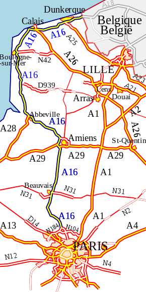
The A16 autoroute – also known as L'Européenne and forming between Abbeville and Dunkirk a part of the larger Autoroute des estuaires – is a motorway in northern France.
The motorway, which has a total length of 319 km (198 mi), starts at L'Isle-Adam in Île-de-France and ends at the Belgian frontier near Bray-Dunes, serving en route Beauvais, Amiens and Abbeville in Picardy, Boulogne-sur-Mer, Calais and Dunkirk in Nord-Pas-de-Calais. From Abbeville, the A16 runs parallel to the English Channel and then the North Sea coast.
The motorway was built in the 1990s to relieve the congested RN1 between Paris and the Côte d'Opale (Boulogne and Calais). Between L'Isle-Adam and Boulogne it is operated by the Société des Autoroutes du Nord et de l'Est de la France (SANEF) and is tolled. From Boulogne to the Belgian border the road is managed by the Direction Départementale de l'Équipement (DDE), which does not impose a toll.
List of junctions
 | ||
| Junction number & name | Northbound exits | Southbound exits |
| RN1, RN184, Presles | RN1, RN184 | |
| RD 922, RN1, L'Île-Adam, Mours, Beaumont-sur-Oise | RD 922, RN1, L'Île-Adam, Mours, Beaumont-sur-Oise | |
| RD 924, Persan, Chambly | ||
| | ||
| RD105, Méru | RD105, Méru | |
| | ||
| | ||
| RN1, Beauvais | RN1, Beauvais | |
| RN31, Beauvais | RN31, Beauvais | |
| | ||
| RD930, Breteuil, Hardivillers-en-Vexin | RD930, Breteuil, Hardivillers-en-Vexin | |
| | ||
| | ||
| A29 | A29 | |
| RN29, Amiens, Salouël | RN29, Amiens, Salouël | |
| A29 | A29 | |
| Amiens | Amiens | |
| RN1, Amiens | RN1, Amiens | |
| | ||
| RN1, Ville-le-Marclet | RN1, Ville-le-Marclet | |
| | ||
| RD925, Abbeville | RD925, Abbeville | |
| A28 | A28 | |
| | ||
| RN1, RD32 Forest-Montiers, Nouvion | RN1, RD32 Forest-Montiers, Nouvion | |
| | ||
| RD303 Berck-Plage | RD303 Berck-Plage | |
| RN39, Le Touquet, Étaples | RN39, Le Touquet, Étaples | |
| | ||
| RD308, Neufchâtel-Hardelot | RD308, Neufchâtel-Hardelot | |
| RN1, Boulogne-sur-Mer, Hesdin-l'Abbé, Isques | RN1, Boulogne-sur-Mer, Hesdin-l'Abbé, Isques | |
| | ||
| RN1, Boulogne-sur-Mer, Outreau, Le Portel | RN1, Boulogne-sur-Mer, Outreau, Le Portel | |
| RD341, Boulogne-sur-Mer, Saint-Martin-Boulogne | ||
| RN42, Boulogne-sur-Mer | RN42, Boulogne-sur-Mer | |
| Boulogne-sur-Mer | Boulogne-sur-Mer | |
| RD940, Wimereux, Wimille | RD940, Wimereux, Wimille | |
| Wacquinghen | ||
| | ||
| RD241, Marquise | ||
| RD191, Marquise | RD191, Marquise | |
| Saint-Inglevert | ||
| | ||
| Saint-Inglevert | ||
| RD243, Bonningues-lès-Calais | RD243, Bonningues-lès-Calais | |
| RD215, Peuplingues, Fréthun | RD215, Peuplingues, Fréthun | |
| Coquelles, Sangatte | Coquelles, Sangatte | |
| Channel Tunnel | Channel Tunnel | |
| RD305, Calais | RD305, Calais | |
| Calais | Calais | |
| Entrance only | ||
| RN43, Calais | RN43, Calais | |
| A26 | A26 | |
| | ||
| RD247, Marck | RD247, Marck | |
| Marck | Marck | |
| | ||
| RD219, Nouvelle-Eglise | RD219, Nouvelle-Eglise | |
| RD218, Saint-Folquin | RD218, Saint-Folquin | |
| Change of numbering | ||
Future extensions
It is projected to extend the A16 south to the Francilienne, the outer Parisian ringroad. Studies were meant to be finalised in Spring 2006.
Public enquiry will take place during the end of the year 2006. The objective is to begin construction of the extension in 2009 and to open the new extension in 2012. This new 8.5 km (5.3 mi) long section wil be operated by the SANEF.
Street lighting
Since 2007, around 70 km (43 mi) of central reservation lights have been switched off, in particular around the Calais and Dunkerque areas. Authorities claim that the result is a significant decrease in the number of accidents. However, the road is now quite difficult to use at night for those unfamiliar with it, especially around Calais where there are numerous junctions close together serving the Channel Tunnel, the Port of Calais (A26 intersection) and all the hypermarkets and shopping centres in between. The lack of lighting on the motorway, and also to the gantry signs, makes it difficult to navigate. This is made worse by the fact that the lighting on the surrounding roads remains switched on, making the motorway itself seem even darker. Unfamiliar users are urged to be cautious.
External links
- (French) A16 autoroute in Saratlas
- (French) Extension of the A16
- (French) Extension of the A16
- (French) Data on the A16
- (French) CPDP PROJET A16
 |
| | |