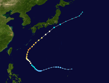
2010 Pacific typhoon season
 | |
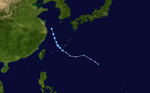
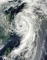
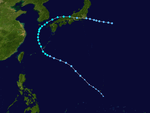
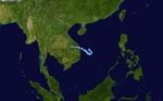
| Season summary map | |
| First system formed | January 18, 2010 |
|---|---|
| Last system dissipated | December 20, 2010 |
| Strongest storm1 | Megi – 885 hPa (mbar), 230 km/h (145 mph) (10-minute sustained) |
| Total depressions | 33 |
| Total storms | 14 official, 1 unofficial (record low) |
| Typhoons | 7 |
| Super typhoons | 1 (unofficial) |
| Total fatalities | 353 |
| Total damage | $1.29 billion (2010 USD) |
| 1Strongest storm is determined by lowest pressure | |
2008, 2009, 2010, 2011, 2012 | |
| Related article | |
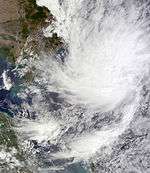
The 2010 Pacific typhoon season was the least active Pacific typhoon season on record, in terms of the number of named storms. The season began with Tropical Depression 01W on January 18. Unlike with other Pacific typhoon seasons, the activity in the first half of 2010 was very weak, and Omais was the only named storm in the period. The season finally became active from July onwards; in addition, three storms— Lionrock, Kompasu, and Namtheun were active simultaneously in late August. In October, Typhoon Megi became the only super typhoon in 2010 and one of the most intense tropical cyclones on record. All of 14 named storms of the season were only active west of 150°E. This season and the 2005 season are the only years that were less active than their respective Atlantic hurricane seasons.
Two systems of the season moved out of the area. On November 1, a tropical depression crossed southern Thailand and entered the North Indian Ocean, before intensifying into Severe Cyclonic Storm Jal. On December 20, a tropical depression (or a subtropical storm) crossed the International Date Line and became Tropical Storm Omeka.
Seasonal forecasts
| TSR forecasts Date | Tropical storms | Total Typhoons | Intense TCs | ACE | Ref |
|---|---|---|---|---|---|
| Average (1965–2009) | 26.6 | 16.6 | 8.6 | 299 | [1] |
| March 8, 2010 | 24.2 | 14.8 | 8.1 | 284 | [1] |
| May 5, 2010 | 24.1 | 14.6 | 9.2 | 321 | [2] |
| July 6, 2010 | 23.0 | 13.6 | 6.7 | 236 | [3] |
| August 4, 2010 | 22.8 | 13.4 | 6.1 | 217 | [4] |
| Other forecasts Date | Forecast Center | Period | Systems | Ref | |
| January 7, 2010 | PAGASA | January 1 — December 31 | 19 tropical cyclones | [5] | |
| June 30, 2010 | CWB | January 1 — December 31 | 20–23 tropical storms | [6] | |
| July 5, 2010 | PAGASA | January 1 — December 31 | 13–15 tropical cyclones | [7] | |
| Forecast Center | Tropical cyclones | Tropical storms | Typhoons | Ref | |
| Actual activity: | JMA | 32 | 14 | 7 | |
| Actual activity: | JTWC | 19 | 14 | 9 | |
| Actual activity: | PAGASA | 11 | 10 | 5 | |
Each season several national meteorological services and scientific agencies forecast how many tropical cyclones, tropical storms, and typhoons will form during a season and/or how many tropical cyclones will affect a particular country.
City University of Hong Kong
Since the 2000 Pacific typhoon season, the Guy Carpenter Asia-Pacific Climate Impact Centre (GCACIC), of the City University of Hong Kong (CityUHK), have issued forecasts of activity for each upcoming typhoon season.[8] Forecasts on the number of tropical cyclones, tropical storms and typhoons there would be during 2010 in the Western Pacific were released in April and June.[8] For the first time this year the GCACIC issued forecasts in May and July, which predicted how many tropical cyclones would make landfall in South China, and pass within 100 km (62 mi) of either the Korean Peninsula or Japan during 2010.[9][10]
In its April 2010 forecast; GCACIC predicted that 28 tropical cyclones, 24 tropical storms, and 16 typhoons would form in the western north Pacific this year.[8] However, in its June forecast the GCACIC reported that they now only expected 27 tropical cyclones, 23 tropical storms, and 15 typhoons, to form during the season.[11] As a result of their predictions the GCACIC also predicted that tropical cyclone activity would be below average for the twelfth year in a row.[11] In May the GCACIC forecasted that between May and December, six tropical cyclones would make landfall on Southern China and another six tropical cyclones would make landfall on or pass within 100 km (62 mi) of either the Korean Peninsula or Japan.[9] In July the GCACIC forecast that between July and December three tropical cyclones would make landfall on Southern China, while four tropical cyclones would make landfall on or pass within 100 km (62 mi) of either the Korean Peninsula or Japan.[10]
Tropical Storm Risk Consortium
Since the 2000 Pacific typhoon season, the Tropical Storm Risk Consortium (TSR) of the University College of London have issued forecasts of activity for each upcoming typhoon season.[1] Forecasts on the number of tropical storms, typhoons and intense typhoons there would be during 2010 in the Western Pacific were released in March, May, July and August.[nb 1] In its March forecast TSR predicted that the season would see activity close to the average with 26 tropical storms, 16 typhoons and seven intense typhoons developing during the season.[1] In its May forecast, while lowering their initial prediction for the amount of tropical storms and typhoons, TSR continued to predict that the season would see activity close to the average, with 24 tropical storms, 15 typhoons and nine intense typhoons developing during the season.[2] In its July forecast TSR significantly lowered their forecast and reported that they now expected activity to be 20% below average, with 23 tropical storms 14 typhoons and seven intense typhoons developing during the season.[3] In its August forecast TSR predicted that activity would be 25% – 30% below average with 23 tropical storms, 13 typhoons and six intense typhoons developing during the season.[4] TSR also predicted that if their August forecast came true then the season would be in the lowest 25% of seasons.[4]
National meteorological service predictions
The Philippine Atmospheric, Geophysical and Astronomical Services Administration (PAGASA) reported on January 7 that they were expecting a total of 19 tropical cyclones to pass through the Philippine area of responsibility during 2010.[5] On March 23 the Hong Kong Observatory (HKO), predicted that less than six tropical cyclones would affect Hong Kong during the season.[12] As a result of being under the influence of a weakening El Niño, the HKO also predicted that the chances of a tropical cyclone affecting Hong Kong before June was not high.[12] After Vietnam was hit by Tropical Depression 01W in January, the Vietnamese National Center for Hydro Meteorological forecasts predicted in May that 6–7 tropical cyclones would affect Vietnam during 2010.[13] While the Thai Meteorological Department predicted that one or two tropical cyclones would affect Thailand between August and November.[14] On June 30, the Central Weather Bureau of Taiwan predicted that the 2010 season would be below its normal climatic average of 26.6, and predicted that 20–23 tropical storms, would occur over the Western Pacific during 2010.[6] The Central Weather Bureau also predicted that between two and four tropical storms would affect Taiwan during 2010.[6] After the slow start to the season, on July 5, PAGASA reported that they now only expected 13–15 tropical cyclones to pass through the region.[7]
Season summary

The first tropical cyclone of the season; Tropical Depression 01W formed on January 18, about 300 km to the northeast of Brunei. During the next 2 days the depression moved quickly and made landfall on Vietnam and dissipated over Cambodia during January 20. The depression caused 3 deaths and caused $243,000 USD in damage to Vietnam. After 01W had dissipated the Western Pacific became dormant until Tropical Storm Omais formed about 325 km (202 mi) to the southeast of Chuuk Island on March 22. During the next couple of days Omais impacted the Micronesian islands of Woleai, Fais Ulithi and Yap, before moving into the Philippine area of responsibility and being named as Agaton by PAGASA. However, Omais (Agaton) dissipated on March 26 before it could affect the Philippines. After Omais dissipated there were 2 non-developing tropical depressions only monitored by the JMA in April and June before on July 11 the first typhoon of the season: Conson formed. Conson quickly intensified becoming a typhoon the next day, before making landfall on the Philippines during July 13.
Overall, there were 14 named tropical storms during the season, which was the lowest on record; this was 2 less than the previous record set in 1998, and 12.7 less than the average of 26.7 storms. Although activity was below normal throughout the year, the quietest time of the year, with respect to climatology, was from October to December. Only two storms formed during the time period, which was 5.7 less than average. The overall inactivity was due to a variety of meteorological conditions, including decreased vorticity and suppressed convection. During the summer of 2010, convective activity in southeastern Asia was shifted to the northern Indian Ocean due to winds in the upper atmosphere. However, sea surface temperatures were above normal due to an ongoing La Niña, despite that typically being a favorable factor in tropical cyclogenesis.[15]
Storms
Tropical Depression 01W
| Tropical depression (JMA) | |||
|---|---|---|---|
| Tropical depression (SSHWS) | |||
| |||
| Duration | January 18 – January 20 | ||
| Peak intensity | 55 km/h (35 mph) (10-min) 1006 hPa (mbar) | ||
On January 16, a disorganized area of low pressure formed in the south China Sea. The next day, it gradually intensified into a weak tropical disturbance by the JTWC. Early on January 18 the JMA reported that it was upgraded to a tropical depression which had formed within the northeast monsoon about 320 km (200 mi) to the north-west of Bandar Seri Begawan in Brunei.[16] The depression's low level circulation center was partially exposed and located within an area of moderate to strong vertical wind shear.[17] However over the next 12 hours, whilst the depression moved towards Vietnam, the low level circulation center rapidly consolidated and became well defined after the vertical wind shear around the system relaxed.[18] As a result of this the JTWC initiated advisories on the depression, designating it as Tropical Depression 01W.[18] During the next day, the depression weakened with the low level circulation center becoming partially exposed, as it moved over an area of cold sea surface temperatures.[19][20] As a result of this the JTWC issued their final advisory on the system later that day.[21] The depression then made landfall on Vietnam near Gò Công early on January 20 before the JMA then issued their final advisory later that day as the system dissipated over Cambodia.[22][23][24]
Within Vietnam strong waves caused by the tropical depression, causing three people to die, while rowing their coracles to find shelter.[25]
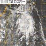
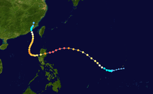
Tropical Storm Omais (Agaton)
| Tropical storm (JMA) | |||
|---|---|---|---|
| Tropical storm (SSHWS) | |||
| |||
| Duration | March 20 – March 26 | ||
| Peak intensity | 65 km/h (40 mph) (10-min) 998 hPa (mbar) | ||
.jpg)

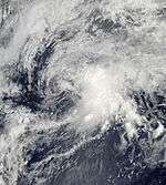
On March 18, the JTWC reported that an area of deep atmospheric convection had persisted about 325 km (202 mi) to the southeast of Chuuk Island in southern Micronesia.[26] At this stage the poorly organised deep convection was located over a low level circulation center and was in an area of low wind shear.[26] Over the next couple of days both the low level circulation center and the deep convection gradually became better organized, prompting the issuance of a tropical cyclone formation alert late on March 20.[27][28][29] During the next day convection continued to build over the low level circulation center, which became well defined whilst moving around the subtropical ridge.[30] The JTWC then initiated advisories on the system later that day, designating it as Tropical Depression 02W, although the JMA did not designate the system as a tropical depression until early on March 22.[30] During March 22 further development of the system was hampered by an anticyclone to the east of the system that caused moderate to strong wind shear.[31][32] Early of the next day, JTWC upgraded the depression into a tropical storm, and on 24 March JMA upgraded it to Tropical Storm Omais, the first of the season. Late on March 25, the JTWC downgraded Omais to tropical depression strength. Tropical Depression Omais re-gained tropical storm status late on March 26 as it was becoming extratropical.[33]
Tropical Depression
| Tropical depression (JMA) | |||
|---|---|---|---|
| |||
| Duration | April 26 – April 27 | ||
| Peak intensity | <55 km/h (35 mph) (10-min) 1008 hPa (mbar) | ||


On April 24, an area of low pressure had been formed about 140 km (87 mi) to the west of Palau Island .[34] On the next day, the disturbance start to move westward. On the same time, the disturbance suddenly strengthened and its LLCC began to consolidate as well as significant banding all over the system and located over moderate vertical wind shear. Early of April 26, the disturbance rapidly strengthen again and was starting to be enhanced by a Tropical Upper Tropospheric Trough (TUTT) cell to the northeast of the system, whilst the JMA upgraded it into a tropical depression. Later that day, the depression made landfall over Davao City and Surigao del Sur boundary and crossed central Mindanao. Early on April 27, JMA downgraded the depression into an area of low pressure while it was located in vicinity of Sulu Island. In the next couple of days the low pressure start to move northwest towards South China Sea. On the same time, the low pressure crossed Palawan Island on the afternoon of April 29. On the next day, the low pressure was located about 415 km (258 mi) from Manila. In the evening of that day, the low pressure was last seen in vicinity of the Zambales area and was absorbed by a frontal system.[35][36]
The depression brought torrential rains to Mindanao causing slight floods in the area. No casualties were reported. When the depression reached Sulu, it was downgraded to a low pressure system. However, it still caused heavy rains in Eastern Visayas, Southern Luzon and Manila.[37]
Tropical Depression
| Tropical depression (JMA) | |||
|---|---|---|---|
| |||
| Duration | June 3 – June 6 | ||
| Peak intensity | Winds not specified 1002 hPa (mbar) | ||

Early on June 2, the JMA reported that an area of low pressure had formed over Hainan island.[38] During the next 36 hours the low pressure area moved to the east before late on June 3, the JMA reported that the system had intensified into a tropical depression whilst located about 600 km (370 mi) to the northwest of Manila, Philippines.[39][40] Over the next couple of days, the depression moved to the northwest before the JMA stopped monitoring the system early on June 6.[41][42]
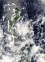
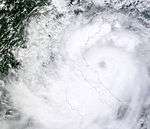
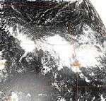
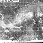
Typhoon Conson (Basyang)
| Typhoon (JMA) | |||
|---|---|---|---|
| Category 1 typhoon (SSHWS) | |||
| |||
| Duration | July 11 – July 18 | ||
| Peak intensity | 130 km/h (80 mph) (10-min) 970 hPa (mbar) | ||
_as_a_Category_1_Typhoon_(07-13-2010).jpg)
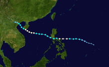
Typhoon Conson, developed into a tropical depression early on July 11 before rapidly developing into the second tropical storm of the season and named as Conson during the next day. During that afternoon Conson, kept intensifying before the JMA reported that Conson had reached its initial ten-minute peak sustained wind speeds of 110 km/h (75 mph), which made it a severe tropical Storm on the JMA's scale. Later that day, the JTWC reported that Conson had intensified into a typhoon before reporting early on July 13 the next day that it had reached its initial one-minute peak sustained wind speeds of 110 km/h (75 mph) which made it a Category 1 typhoon on the Saffir Simpson Hurricane Scale. During July 13, Conson started to weaken as it interacted with the Philippines before it made landfall near General Nakar, Quezon. Whilst over the Philippines Conson moved towards the west and passed over Manila before moving into the South China Sea early on July 14. During that day Conson weakened further under the influence of high vertical wind shear before during the next day the vertical wind shear weakened slightly. As a result, Conson intensified over the South China Sea and became a typhoon early on July 16, with the JMA reporting ten-minute peak sustained wind speeds of 130 km/h (80 mph), whilst the JTWC reported peak one minute wind speeds of 150 km/h (90 mph) later that day as it passed closed to Hainan Island. After passing close to Hainan island, Conson moved into an area with high levels of vertical wind shear and as a result it rapidly weakened into a tropical storm, before making landfall in Vietnam during July 17. On July 18 Conson dissipated.
On the morning of July 13, DEPED suspended all elementary and preschool classes in Metro Manila and some other provinces. All flights were canceled due to heavy rains and strong winds brought by Conson. Severe flooding was also reported in Bicol Region. In addition, Conson sank three fishing vessels in the province of Catanduanes, Philippines. JTWC's 6:00 bulletin indicated that Conson would be passing through Metro Manila at about 2 or 3 in the morning the following day, which it did.
By late evening, Conson began its westerly path towards the direction of Metro Manila. Heavy rains and strong winds battered the Metropolis throughout the night. By 11 pm, PAGASA raised storm warning in the Metro to Signal number two. At 12:42 am, Meralco cut off power supplies to Metro Manila and nearby areas amidst various reports that billboards fell through power lines around the area; as much as 12 million people in Metro Manila alone still have their power services restored by the afternoon. At least twenty-six people were killed, and 38 were left missing in the Philippines as a result of the storm.[43][44] The province of Laguna was placed under a state of calamity as a result of the storm. An estimated P47 million worth of agricultural products were damaged in the province. On July 16, the National Disaster Coordinating Council has revised the death toll to 38.[45] The power outage also rendered the PAGASA website offline.
Typhoon Chanthu (Caloy)
| Typhoon (JMA) | |||
|---|---|---|---|
| Category 1 typhoon (SSHWS) | |||
| |||
| Duration | July 18 – July 23 | ||
| Peak intensity | 130 km/h (80 mph) (10-min) 970 hPa (mbar) | ||
.jpg)

Early on July 17, the JMA reported that a tropical depression had developed about 220 km (140 mi) to the northeast of Manila, Philippines.[46] Later that day the JTWC reported that the depression had a small low level circulation center with deep convection flaring to the northeast of the center. However, as the low level circulation center was located close to land and was not very organized, the JTWC declared that there was a poor chance of it becoming a significant tropical cyclone within 48 hours. However, during that day, the depression rapidly consolidated with an anticyclone helping to develop the low level circulation center. As a result, early the next day the JTWC issued a tropical cyclone formation alert on the depression, however they thought that further development might be hindered as it was located close to land. Whilst it moved along the southern edge of the subtropical ridge, the Depression made landfall on Aurora province at 0600 UTC, before the JTWC initiated advisories later that morning, as the low level circulation center had consolidated and poleward outflow into the tropical upper tropospheric trough had improved. Late on July 19, PAGASA issued their last advisory on Tropical Storm Caloy as it had moved out of their Area of Responsibility. Following the system's development, PAGASA stated that rainfall from system could trigger landslides and flooding in Aurora, the Bicol Region, and Quezon.[47] Throughout Aurora, heavy rains triggered flash flooding which destroyed at least one home and stranded hundreds of residents. The Paltic barangay, within Dingalan, became inaccessible to rescuers after the local river topped its banks and washed out nearby slopes.[48]
When it rain bands passed over Hong Kong, heavy rains brought about serious floodings across the territory. The Black Rainstorm Signal was issued. Two people were drowned and found dead, and two are still missing.
Tropical Depression
| Tropical depression (JMA) | |||
|---|---|---|---|
| |||
| Duration | July 18 – July 20 | ||
| Peak intensity | 55 km/h (35 mph) (10-min) 1004 hPa (mbar) | ||
.jpg)
Early on July 17, an area of low pressure formed about 415 km (258 mi), southeast of Okinawa, Japan. The next day, the low pressure started to move slowly northwest. On the evening of July 18 at 12:00 (UTC), JMA reported that the low pressure intensified into a minor tropical depression. On the next day, the depression continued to move northwest until on early of July 20, the depression was absorbed by frontal system. On that same day, the Japan Meteorological Agency issued their final advisory on the depression.
Tropical Depression
| Tropical depression (JMA) | |||
|---|---|---|---|
| |||
| Duration | July 24 – July 25 | ||
| Peak intensity | <55 km/h (35 mph) (10-min) 1008 hPa (mbar) | ||
Early on July 24, the JMA reported that a tropical depression had formed about 50 km (31 mi) to the east of Taipei, Taiwan.[49] The depression was in an area of moderate vertical windshear and had a broad low level circulation.[50] Later the next day on July 25, the depression made landfall in Yilan County before the JMA stopped monitoring the depression as it dissipated near the coast of Fujian province.[51][52][53]
Tropical Depression
| Tropical depression (JMA) | |||
|---|---|---|---|
| |||
| Duration | July 26 – July 28 | ||
| Peak intensity | 55 km/h (35 mph) (10-min) 1002 hPa (mbar) | ||
.jpg)

Late on July 26 the JMA reported that a tropical depression had formed off the coast of Zhejiang province, within a monsoonal trough about 400 km (250 mi) to the south of Shanghai China. During the next day the depression remained offshore and moved towards the north passing about 120 km (75 mi) to the southeast of Shanghai before early on July 28 weakening into an area of low pressure. During that day the area of low pressure kept moving north before dissipating later that day as it affected South Korea.
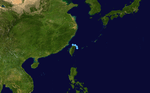
Tropical Storm Domeng
| Tropical storm (PAGASA) | |||
|---|---|---|---|
| |||
| Duration | August 3 – August 5 | ||
| Peak intensity | 65 km/h (40 mph) (10-min) 997 hPa (mbar) | ||
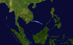
_2010_track.png)
Late on August 2, PAGASA reported that a low pressure area had formed within the Intertropical convergence zone about 570 km to the northeast of Virac, Catanduanes.[54] Early the next day PAGASA reported that the low pressure area had intensified into a tropical depression and named it as Domeng.[55] During that day Domeng interacted with another low pressure area which was located to the north of the system, before merging with it early on August 4. After Domeng, had merged with the low pressure area PAGASA reported that Domeng had intensified into a tropical storm and reached its 10-minute peak sustained windspeeds of 65 km/h (40 mph). Later that day PAGASA reported that Domeng had weakened into a tropical depression, before reporting early the next day that after it had passed through the Babuyan Islands, Domeng had weakened into an area of low pressure.
In Luzon, heavy rain produced by the storm led to a few landslides, prompting road closures. Offshore, three people drowned after their boat capsized amidst rough seas produced by Domeng.[56]
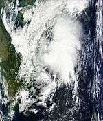
Severe Tropical Storm Dianmu (Ester)
| Severe tropical storm (JMA) | |||
|---|---|---|---|
| Tropical storm (SSHWS) | |||
| |||
| Duration | August 6 – August 12 | ||
| Peak intensity | 95 km/h (60 mph) (10-min) 985 hPa (mbar) | ||

Early on August 6, the JTWC reported that a tropical disturbance formed within the monsoon gyre about 800 km (500 mi) southeast of Taipei, Taiwan. Later that day PAGASA reported that the disturbance had developed into a tropical depression and named it as Ester, before the JTWC issued a tropical cyclone formation alert early the next day. During that day the JMA started to monitor the depression before the JTWC designated it as Tropical Depression 05W. The depression was then upgraded into a tropical storm by the JMA and named "Dianmu", the mother of lightning in Chinese folklore, with the JTWC following suit soon after. Early the next day, the JMA further upgraded the tropical storm into a severe tropical storm. After moving northward for several days, it turned northeastward and struck southern South Korea. Dianmu weakened as it crossed the Korean peninsula and emerged into the Sea of Japan
Heavy rains produced by the storm resulted in one fatality after a cargo ship sank amidst rough seas produced by the storm.[57] In South Korea, at least three people were killed by Dianmu in flood-related incidents. This marked the first time in nine years that a rain-related fatality took place in the capital city of Seoul.[58] More than 3,000 homes were destroyed in eastern China after heavy rains from the outer bands of Dianmu struck the region.[59] Later reports stated that five people had been confirmed to have died as a result of Dianmu in South Korea.[60] The storm made landfall on Japan; exiting the country within five hours. Heavy rains were reported throughout the islands.
Nearly a week after the two ships sank off the coast of the Philippines, 31 crew members remain missing and are presumed dead after numerous coast guard rescue attempts. Damage from the storm on Jeju Island amounted to 5 billion won ($4.2 million USD).[61]
Tropical Storm Mindulle
| Tropical storm (JMA) | |||
|---|---|---|---|
| Category 1 typhoon (SSHWS) | |||
| |||
| Duration | August 21 – August 26 | ||
| Peak intensity | 85 km/h (50 mph) (10-min) 985 hPa (mbar) | ||
Early on August 17, an area of low pressure formed about 415 km (258 mi), northeast of Tuguegarao City, Cagayan. The next day the disturbance started to move west. However, on the evening of August 18, as it crossed Babuyan Islands, the disturbance's low level center (LLC) weakened due to land interaction and high vertical wind shear. It regenerated on August 20 when it was located about 280 km (170 mi), to the west of Dagupan City, Pangasinan. Early on the next day, the disturbance started to move west and located in warm water temperatures and favorable conditions with moderate vertical wind shear. At the same time, the LCC of the disturbance became partially exposed due to a Tropical Upper Tropospheric Trough (TUTT) that was developing off Luzon at that time. On the afternoon of that day, Japan Meteorological Agency (JMA) upgraded the system into a tropical depression.[36][62] The next day, they further upgraded the depression into a tropical storm and named it "Mindulle". At the same time, the JTWC reported that Tropical Depression 06W has intensified into a tropical storm. Due to land reaction, Mindulle rapidly weakened on August 25 and fully dissipated and made their final warning very early on August 26.
As the storm neared Vietnam, thousands of fishermen were urged to return to port. According to Vietnamese officials, contact was lost with 10 vessels on August 24 and the 137 fishermen on the ships were listed as missing.[63] Widespread heavy rainfall, peaking at 297 mm (11.7 in),[64] led to significant flooding and agricultural losses across Vietnam.[65] Across the country, at least 10 people were killed and losses reached ₫850 billion (US$43.3 million).[66]
Tropical Depression
| Tropical depression (JMA) | |||
|---|---|---|---|
| |||
| Duration | August 26 – August 29 | ||
| Peak intensity | 55 km/h (35 mph) (10-min) 1004 hPa (mbar) | ||
.jpg)

Severe Tropical Storm Lionrock (Florita)
| Severe tropical storm (JMA) | |||
|---|---|---|---|
| Tropical storm (SSHWS) | |||
| |||
| Duration | August 26 – September 3 | ||
| Peak intensity | 95 km/h (60 mph) (10-min) 985 hPa (mbar) | ||


Early on August 25, an area of low pressure formed about 415 km (258 mi) east of Cagayan, Philippines. The low pressure was located in an area of low vertical wind shear and a favorable environment. At the same time, a tropical upper tropospheric trough (TUTT) was located in the east of the system. On the next day, the disturbance started to move west and later crossed the island of Luzon but on the next day, the circulation became slightly disorganized due to dry air. Later that afternoon, the Japan Meteorological Agency (JMA) upgraded the disturbance to a tropical depression and the Joint Typhoon Warning Centre (JTWC) issued a Tropical Cyclone Formation Alert (TCFA) which was later upgraded to a tropical depression. On August 28, the JMA upgraded the system to a tropical storm and it was named "Lionrock". For the next couple of days, Lionrock remained almost stationary in South China Sea. On August 31, Lionrock start to move northeast slowly due to interaction with tropical storm Namtheun. Early on September 1, Lionrock made a Fujiwhara effect with Namtheun, while Lionrock maintained its strength while Namtheun was absorbed. Lionrock made landfall on the east coast of Guangdong Province, China, just north of the city of Shantou. It then started to dissipate and weaken into a tropical storm and moved over Guangzhou, Guangdong's capital. Lionrock soon lost its intensity as it went over Guangdong, and on September 3, the storm had turned into a low pressure area.
Typhoon Kompasu (Glenda)
| Typhoon (JMA) | |||
|---|---|---|---|
| Category 3 typhoon (SSHWS) | |||
| |||
| Duration | August 28 – September 2 | ||
| Peak intensity | 150 km/h (90 mph) (10-min) 960 hPa (mbar) | ||

On early August 27, an area of low pressure formed about 305 km (190 mi) to the east of Yap Island. At that time, the system was disorganized due to high vertical wind shear. On the next day, the system started to move northwest and crossed Guam island. On the evening of that day, the system was located about 370 km (230 mi) northwest of Guam. At that time, the system experienced low vertical windshear and was located in a favorable environment. A Tropical Upper Tropospheric Trough (TUTT) was located to the east of the system. At that time, the Japan Meteorological Agency (JMA) upgraded the system into a tropical depression. Midday of August 29, the Joint Typhoon Warning Centre (JTWC) issued a Tropical Cyclone Formation Alert (TCFA) on the system as the Low Level Circulation Centre had become organized. On the morning of that same day, the JTWC announced that the system had quickly developed into a tropical storm and assigned the designation "08W". Intensification continued, then by midday of August 30, the JMA reported that the depression had intensified into a tropical storm and assigned it the international designation "Kompasu". In addition, PAGASA also announced that the low pressure in the northeast of Batanes had formed and assigned it a local name, "Glenda". After six hours, the JMA reported that Kompasu had intensified rapidly into a severe tropical storm. At the same time, the JTWC also upgraded Kompasu into a Category 1 typhoon. On the next day, Kompasu crossed the island of Okinawa and rapidly intensified into a Category 2 typhoon equivalent. On September 1, Kompasu was upgraded by JTWC as a Category 3 typhoon equivalent, becoming the 3rd strongest typhoon of the season at the time.
The storm later weakened to a Category 1 typhoon in the Yellow Sea, before veering northeast and making landfall on Ganghwa Island, northwest of Incheon and Seoul, killing at least four people.[67] Kompasu was the strongest tropical storm to hit the Seoul metropolitan area in 15 years.[68] Kompasu weakened to a tropical storm over the Sea of Japan on September 2.
Tropical Storm Namtheun
| Tropical storm (JMA) | |||
|---|---|---|---|
| Tropical storm (SSHWS) | |||
| |||
| Duration | August 28 – September 1 | ||
| Peak intensity | 65 km/h (40 mph) (10-min) 996 hPa (mbar) | ||


On August 27, an extensive cloud formed in the waters east of Taiwan. On August 28, it developed into a low pressure. At 18:00, near Yaeyama Islands, the Japan Meteorological Agency upgraded the low pressure into a tropical depression. There were two tropical cyclones developing on both sides of 09W (namely Lionrock and Kompasu), and Typhoon Kompasu had a relatively stronger intensity, causing 09W moved southwest to Taiwan Strait. This tropical depression lingered in the east of Taiwan for over a day. On August 30, it caused heavy rain in northern Taiwan. Taiwan's Central Weather Bureau could only issue a tropical depression warning since it had not strengthened to a tropical storm. At 20:00, 09W suddenly intensified into a tropical storm, and was named Namtheun. However, due to the development of another stronger tropical storm Lionrock at South China Sea, the increase of intensity of Namtheun was difficult. In the evening hours of August 31, Namtheun weakened into a tropical depression north of Taiwan Strait, then continued to move south to southwest, and skirted the southern coast of Fujian province. It continued to weaken, and finally transformed into a low pressure along the coast of Huian, Guangdong. Early of September 1, Lionrock made a Fujiwhara effect with Namtheun, whilst Lionrock maintained its strength while Namtheun was absorbed by Lionrock and fully dissipated early on the 1st of September.
Tropical Depression
| Tropical depression (JMA) | |||
|---|---|---|---|
| |||
| Duration | August 29 – September 1 | ||
| Peak intensity | <55 km/h (35 mph) (10-min) 1008 hPa (mbar) | ||


Late on August 28, the Central Pacific Hurricane Center reported that an area of low pressure associated with a tropical disturbance had developed about 1,000 mi (1,600 km) to the southwest of Honolulu in Hawaii. Isolated thunderstorms were developing in association with the small low-level circulation. During the next day the disturbance moved towards the west and moved into the western Pacific where the JMA immediately designated it as a tropical depression. The depression was expected to bring inclement weather to Majuro and nearby atolls, although the system significantly weakened before reaching the area. The depression dissipated completely very late on August 31.[69][70]
Severe Tropical Storm Malou (Henry)
| Severe tropical storm (JMA) | |||
|---|---|---|---|
| Tropical storm (SSHWS) | |||
| |||
| Duration | September 1 – September 10 | ||
| Peak intensity | 95 km/h (60 mph) (10-min) 992 hPa (mbar) | ||

Malou started out as a tropical depression wardering around the Western Pacific. It moved into the Philippine Area of Responsibility and was given the name Henry. It remained for a depression for two days before it strengthened into a tropical storm and was given the name Malou. Malou drifted over the Okinawa Islands and became a severe tropical storm. After passing through the Okinawa Islands, Malou was expected to make a landfall on Jeju Island; instead, it turned northeast and landed on Tsushima Island as a tropical storm on September 7. It then moved along the coast of Honshū and made another landfall near Tsuruga, Fukui Prefecture, Japan on September 8. After the second landfall, Malou weakened into a tropical depression over Shizuoka Prefecture. Nevertheless, it lingered over Kantō region and caused heavy rain in Greater Tokyo Area[71] until it transitioned into a polar low on September 10.
Off the northeastern coast of China, an oil rig was knocked on a 45 degree angle by large waves produced by Tropical Storm Malou. The severe tilting sent 32 workers overboard; 30 of these workers were quickly rescued but the remaining two remain missing.[72] In Japan, Malou produced record heavy rains, exceeding 100 mm (3.9 in) per hour, resulting in severe flash flooding. Several rivers burst their banks and inundated nearby areas. A few bridges were destroyed; however, no loss of life took place. The rains also brought an end to one of the hottest and longest heat waves in Japanese history.[73] Southwest of Tokyo, roughly 10,000 people were advised to evacuate their homes due to the threat of dangerous flash floods and landslides.[74]
Severe Tropical Storm Meranti
| Severe tropical storm (JMA) | |||
|---|---|---|---|
| Category 1 typhoon (SSHWS) | |||
| |||
| Duration | September 6 – September 10 | ||
| Peak intensity | 100 km/h (65 mph) (10-min) 985 hPa (mbar) | ||


Early on September 6, the JMA reported that a tropical depression had formed about 330 km (210 mi) to the southeast of Taipei, Taiwan. Later that day the JTWC started to monitor the system and reported that the depression, had an unorganized low level circulation center that had convection flaring over it and was located in a favorable environment of decreasing vertical windshear and high sea surface temperatures. During the next day as the depression moved towards Taiwan the system became better organized with a tropical cyclone formation alert issued later that day. In the morning of September 9, JMA upgraded the cyclone into a tropical storm, and it was named Meranti. After Meranti was upgraded into a tropical storm, it continued to move northward into Taiwan Strait. In the early hours of September 10, Meranti made a landfall at Shishi City, Quanzhou, Fujian Province, China. It continued to move north toward inland Fujian. In the evening of September 10, the JMA downgraded Meranti into a tropical depression.
At least three people were killed by the storm and damage amounted to $117.7 million.[75] In Hong Kong, a violent thunderstorm associated with Meranti produced a record 13,102 strikes of lightning in one hour. Several skyscrapers were struck by lightning, resulting in five incidents of people becoming trapped in stalled-out elevators. Torrential rains, exceeding 40 mm (1.6 in) per hour triggered flash flooding and wind gusts up to 100 km/h (62 mph) were recorded.[76]
In post-storm analysis, the JMA upgraded Meranti into a severe tropical storm.
Typhoon Fanapi (Inday)
| Typhoon (JMA) | |||
|---|---|---|---|
| Category 3 typhoon (SSHWS) | |||
| |||
| Duration | September 14 – September 21 | ||
| Peak intensity | 175 km/h (110 mph) (10-min) 930 hPa (mbar) | ||


Late on September 14, the JMA reported that a tropical depression had formed southeast of Taiwan, and the JTWC soon designated it as 12W with the PAGASA naming it Inday shortly thereafter. Later that day, both the JMA and the JTWC upgraded the system to a tropical storm and named it Fanapi. On September 16, the storm intensified into a typhoon and turned northwest. On September 18, Fanapi further intensified to a category 3 typhoon and moved straight into Taiwan. It made landfall over Hualien County early on September 19.[77] Because of land interaction, Fanapi moved southwest, again turned west and weakened into a severe tropical storm. After staying inland for about nine hours, Fanapi moved to the Taiwan Strait and made its second landfall over Zhangpu in Fujian, China.[78][79] Late on September 20, Fanapi weakened into a tropical depression over Guangdong, China, and it dissipated completely on the next day.
Typhoon Malakas
| Typhoon (JMA) | |||
|---|---|---|---|
| Category 2 typhoon (SSHWS) | |||
| |||
| Duration | September 20 – September 25 | ||
| Peak intensity | 155 km/h (100 mph) (10-min) 945 hPa (mbar) | ||


On September 20, the JTWC had reported that a Tropical Depression had formed and designated it with 13W.[80] Later on the same day, the depression strengthened slightly. The next day, JMA started monitoring the depression while the JTWC upgraded it into a Tropical Storm. Later on the same day, the JMA further upgraded it into a tropical storm naming it "Malakas".[81] On September 22, the storm strengthened further and moved towards the Japanese Islands.[82] The next day, the storm intensified into a Severe tropical storm. The JTWC directly upgraded the storm into a Typhoon that time. Later on that day, the JTWC reported that the Typhoon weakened to a tropical storm unexpectedly. By the next day, the storm reintensified into a Category 1 typhoon and further intensified into a Category 2 typhoon on the SSHS. The JMA also reported that the system had intensified into a Typhoon. By the next day, the JTWC reported that the storm had weakened into a Category 1 typhoon issuing its final warning while the JMA announced the storms closest approach to Japan. The system later transitioned into a powerful extratropical cyclone on September 25, which stalled near Alaska for a few days, until it was absorbed by a larger extratropical storm on October 1.
Tropical Depression
| Tropical depression (JMA) | |||
|---|---|---|---|
| |||
| Duration | September 29 – September 30 | ||
| Peak intensity | 45 km/h (30 mph) (10-min) 1008 hPa (mbar) | ||


Tropical Depression 14W
| Tropical depression (JMA) | |||
|---|---|---|---|
| Tropical depression (SSHWS) | |||
| |||
| Duration | October 5 – October 11 | ||
| Peak intensity | 55 km/h (35 mph) (10-min) 1004 hPa (mbar) | ||


On October 5, the JTWC reported that a tropical depression had formed from a low pressure in the South China Sea.[83] The depression made landfall without any warnings, no damage or deaths have been reported in that day. The depression maintained full strength and didn't weaken as it moved farther inland.[84] However, as it approached South China on October 6, the depression began weakening and the final warning was issued for the system. The system continued to weaken as it made landfall on South China on October 7, and moved back over the South China Sea. Later on the same day, the depression degenerated to the remnant low. The system continued to drift in the South China Sea for the 4 days. During this time, the remnant low regenerated slightly, but didn't restrengthen into a tropical depression, and the system dissipated on October 11 near Hong Kong.
Tropical Depression
| Tropical depression (JMA) | |||
|---|---|---|---|
| |||
| Duration | October 7 – October 8 | ||
| Peak intensity | <55 km/h (35 mph) (10-min) 1012 hPa (mbar) | ||

The JMA had briefly monitored a weak tropical depression several miles to the east of Japan on October 7. The system dissipated the next day as it was absorbed by a stationary front.[85]
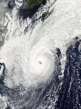
Typhoon Megi (Juan)
| Typhoon (JMA) | |||
|---|---|---|---|
| Category 5 super typhoon (SSHWS) | |||
| |||
| Duration | October 12 – October 24 | ||
| Peak intensity | 230 km/h (145 mph) (10-min) 885 hPa (mbar) | ||

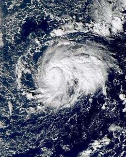
Late on October 12, JMA reported that a tropical depression formed west of Guam.[86] During October 13, JTWC designated the tropical depression as 15W.[87] Later that day, the system intensified into a tropical storm named Megi by JMA.[88] On October 14, JTWC upgraded it to a typhoon, so did JMA on the next day.[89] Later, PAGASA began to issue advisories on Megi and named it Juan.[90] Early on October 17, JTWC upgraded Megi to a Category 5 super typhoon— the only super typhoon in 2010 and the first since Nida in 2009.[91] According to RSMC Best Track Data, Megi attained peak intensity at 18Z and 00Z. Megi made landfall over Luzon early on October 18.[92]
By passing Luzon and reaching the South China Sea, Megi significantly weakened on October 18 and 19.[93] Because of low vertical wind shear and good radial outflow, the typhoon intensified again on October 20 and reached its second peak intensity on October 21.[94] Due to subsidence and increasing vertical wind shear, Megi began to weaken on October 22.[95] Megi made landfall over Zhangpu in Fujian, China and weakened to a tropical storm on October 23.[96] Later that day, Megi further weakened to a tropical depression before dissipating completely on October 24.
Tropical Depression
| Tropical depression (JMA) | |||
|---|---|---|---|
| |||
| Duration | October 18 – October 20 | ||
| Peak intensity | <55 km/h (35 mph) (10-min) 1010 hPa (mbar) | ||

Early on October 18, the JMA reported that a tropical depression, had formed about 1000 km, (620 mi), to the southwest of Wake island. However, early on October 20, the JMA issued their final advisory on the tropical depression as it weakened into an area of low pressure, and then dissipated.[97][98][99]
Typhoon Chaba (Katring)
| Typhoon (JMA) | |||
|---|---|---|---|
| Category 4 typhoon (SSHWS) | |||
| |||
| Duration | October 20 – October 30 | ||
| Peak intensity | 175 km/h (110 mph) (10-min) 930 hPa (mbar) | ||
Early on October 20, the Japan Meteorological Agency (JMA) upgraded an area of low pressure into a tropical depression.[100] Later that day, the JMA reported that the tropical depression slightly intensified.[101] The next day, the Joint Typhoon Warning Center started monitoring the system as tropical depression 16W.[102] On October 23, the system entered the Philippine Area of responsibility and the Philippine Atmospheric, Geophysical and Astronomical Services Administration (PAGASA) started monitoring the system as Tropical Depression "Katring"[103] On October 24, the JMA and JTWC upgraded the tropical depression into a tropical storm and the JMA named it "Chaba".[104][105] On October 25, the JMA further upgraded the storm into a Severe Tropical Storm.[106] Later that day, the JTWC upgraded the storm into a Category 1 Typhoon.[107] Early on October 26, the JMA further upgraded the storm into a Typhoon.[108] Early on October 27, the JTWC upgraded the typhoon into a Category 2 Typhoon.[109] The following day the JTWC upgraded the system into a Category 4 Typhoon, but soon after weakened back to a Category 3.[110][111] Late on October 29, the JMA had downgraded the typhoon into a Severe Tropical Storm while the JTWC downgraded it into a Category 1 Typhoon.[112][113] Early on October 30, the JTWC reported that Chaba had transitioned into an extratropical cyclone.[114] During the afternoon of October 30, the JMA downgraded Chaba to a remnant low as passed near Japan. The remnants of Chaba continued to weaken rapidly as it slowly moved northwest, until it dissipated completely on October 31.
Tropical Depression 17W
| Tropical depression (JMA) | |||
|---|---|---|---|
| Tropical depression (SSHWS) | |||
| |||
| Duration | October 20 – October 27 | ||
| Peak intensity | 55 km/h (35 mph) (10-min) 1006 hPa (mbar) | ||
.jpg)

Early on October 20, the Japan Meteorological Agency (JMA) upgraded an area of low pressure into a tropical depression.[115] Late on the next day, the Joint Typhoon Warning Center (JTWC) identified the same system as Tropical Depression 17W.[116] On October 23, the JTWC downgraded the depression into a remnant low.[117] Early on October 26, the JMA issued their final advisory on the depression. However early, the next day the JMA reported that the system had re-intensified into a tropical depression and reissuing advisories on it, whilst it was located about 1400 km to the southwest of Chiba, Japan. However, later that day, the depression to a remnant low, with the JMA issuing their final advisory on the system. The remnants of the depression dissipated completely early on October 28.
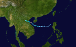
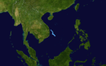
Tropical Depression Jal
| Depression (IMD) | |||
|---|---|---|---|
| |||
| Duration | October 31 – November 1 (Out of area) | ||
| Peak intensity | 45 km/h (30 mph) (3-min) 1006 hPa (mbar) | ||
_nov_2.jpg)

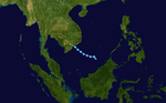
On October 29, the Japan Meteorological Agency (JMA) and the Joint Typhoon Warning Center (JTWC), reported that a tropical disturbance had developed within a monsoonal trough of low pressure, about 550 km (340 mi), to the southeast of Ho Chi Minh City, Vietnam.[118][119][120] During that day the disturbance moved towards the southwest before the JTWC reported the next day, that the disturbance had a developing low level circulation center associated with a weak area of convection, which showed no signs of organizing.[119][121] Over the next couple of days, convection around the disturbance increased but failed to organize around the disturbances low level circulation center.[122][123] Despite this on October 31, as the disturbance moved into the Gulf of Thailand, the Thai and Malaysian meteorological departments reported that the disturbance had developed into a tropical depression, and initiated advisories on the tropical depression.[124][125][126] On November 1, the depression made landfall on Thailand, before moving into the North Indian Ocean and intensifying into Severe Cyclonic Storm Jal.[119][125][127]
Tropical Depression
| Tropical depression (JMA) | |||
|---|---|---|---|
| |||
| Duration | November 3 – November 5 | ||
| Peak intensity | 55 km/h (35 mph) (10-min) 1006 hPa (mbar) | ||
On November 3, the JMA reported that a tropical depression had developed within an area of moderate vertical windshear, about 500 km (310 mi) to the northeast of Ho Chi Minh City in Southern Vietnam.[128][129] During that day the depression moved westwards as its low level circulation center gradually consolidated further, before the JTWC issued a tropical cyclone formation alert on the system.[130]
Tropical Depression 18W
| Tropical depression (JMA) | |||
|---|---|---|---|
| Tropical depression (SSHWS) | |||
| |||
| Duration | November 12 – November 14 | ||
| Peak intensity | 55 km/h (35 mph) (10-min) 1004 hPa (mbar) | ||
On November 10, an area of low pressure associated with a monsoon trough formed in the central South China Sea. On November 11, the low pressure area became a strong tropical disturbance wave. During the next day, the Japan Meteorological Agency (JMA) reported that the system had intensified into a Tropical Depression.[131] Later that day, JTWC issued Tropical Cyclone Formation Alert for system, and eventually, it was numbered Tropical Depression 18W.[132] It made landfall south of Da Nang, Vietnam on November 14, and it dissipated later in the day.[133]
Tropical Depression 19W
| Tropical depression (JMA) | |||
|---|---|---|---|
| Tropical depression (SSHWS) | |||
| |||
| Duration | December 12 – December 13 | ||
| Peak intensity | 55 km/h (35 mph) (10-min) 1004 hPa (mbar) | ||

On December 11, an area of low pressure associated with a monsoon trough formed in the south of South China Sea. Later that day, the low pressure area became a strong tropical disturbance wave. During the next day, the Joint Typhoon Warning Center (JTWC) reported that the system had intensified into Tropical Depression 19W, while the JMA upgraded the system to a tropical depression.[134][135] On December 13, JWTC and the JMA both issued their last advisory on Tropical Depression 19W, as it dissipated completely over the northwestern part of the South China Sea, without impacting any major land masses.
Tropical Depression Omeka
| Tropical depression (JMA) | |||
|---|---|---|---|
| Subtropical storm (SSHWS) | |||
| |||
| Duration | December 19 – December 20 (Exited basin) | ||
| Peak intensity | 55 km/h (35 mph) (10-min) 998 hPa (mbar) | ||

On December 18 the CPHC initiated special weather outlooks for a subtropical depression located near the International Date Line.[136] The system soon crossed this line, and the next day JMA classified it as a Tropical Depression, about 2,600 km (1,615 mi) to the west of Hilo, Hawaii.[137] Although the JTWC has not issued an advisory on the system, they noted that it was a subtropical cyclone with sustained winds of at least 85 km/h (50 mph) and had a pressure of 990 mbar (hPa).[138] However, there is a disagreement between warning centers on the nature of the system. While west of the dateline, the CPHC referred to the system as a tropical cyclone while the JTWC considered it a subtropical disturbance.[136][138] Early on December 20, the JTWC issued its last significant tropical weather outlook on Tropical Depression 01C, as it crossed back over the international dateline, back over the Central Pacific basin, passing on the authority of monitoring the system over to the CPHC.[139] During the storm's time in the Central Pacific, it was known as Tropical Storm Omeka.[136]
Storm names
Within the North-western Pacific Ocean, both the Japan Meteorological Agency (JMA) and the Philippine Atmospheric, Geophysical and Astronomical Services Administration assign names to tropical cyclones that develop in the Western Pacific, which can result in a tropical cyclone having two names.[140] The Japan Meteorological Agency's RSMC Tokyo — Typhoon Center assigns international names to tropical cyclones on behalf of the World Meteorological Organization's Typhoon Committee, should they be judged to have 10-minute sustained windspeeds of 65 km/h, (40 mph).[141] While the Philippine Atmospheric, Geophysical and Astronomical Services Administration assigns names to tropical cyclones which move into or form as a tropical depression in their area of responsibility located between 135°E and 115°E and between 5°N-25°N even if the cyclone has had an international name assigned to it.[140] The names of significant tropical cyclones are retired, by both PAGASA and the Typhoon Committee.[141] Should the list of names for the Philippine region be exhausted then names will be taken from an auxiliary list of which the first ten are published each season. Unused names are marked in gray.
International names
During the season 14 named tropical cyclones developed in the Western Pacific and were named by the Japan Meteorological Agency, when it was determined that they had become tropical storms. These names were contributed to a list of a 140 names submitted by the fourteen members nations and territories of the ESCAP/WMO Typhoon Committee. The names Lionrock and Fanapi were used for the first time, as it was replaced from Tingting and Rananim.
| Omais | Conson | Chanthu | Dianmu | Mindulle | Lionrock | Kompasu |
| Namtheun | Malou | Meranti | Fanapi | Malakas | Megi | Chaba |
Philippines
| Agaton | Basyang | Caloy | Domeng | Ester |
| Florita | Glenda | Henry | Inday | Juan |
| Katring | Luis (unused) | Mario (unused) | Neneng (unused) | Ompong (unused) |
| Paeng (unused) | Queenie (unused) | Ruby (unused) | Seniang (unused) | Tomas (unused) |
| Usman (unused) | Venus (unused) | Waldo (unused) | Yayang (unused) | Zeny (unused) |
| Auxiliary list | ||||
|---|---|---|---|---|
| Agila (unused) | Bagwis (unused) | Chito (unused) | Diego (unused) | Elena (unused) |
| Felino (unused) | Gunding (unused) | Harriet (unused) | Indang (unused) | Jessa (unused) |
During the season PAGASA used its own naming scheme for the 11 tropical cyclones, that either developed within or moved into their self-defined area of responsibility.[142] The names were taken from a list of names, that had been last used during 2006 and are scheduled to be used again during 2014.[142]
After the season the names Juan and Katring were retired by PAGASA, as they had caused over 300 deaths and over Php1 billion in damages. They were subsequently replaced on the list with Jose and Kanor.[143][144] However in 2014, PAGASA had revised their list and switched the name from Kanor to Karding after negative feedback from the public.[145][146]
Retirement
During their 2011 annual session the ESCAP/WMO Typhoon Committee, announced that the name Fanapi, would be retired from its naming lists and was replaced with the name Rai. The names Juan and Katring were retired from PAGASA's list of name after they both became destructive tropical cyclones over the country.[147][145][146] They were subsequently replaced with the names Jose and Kanor, later replaced by Karding, when the lists of names were next used in 2014.[146]
Season effects
This table lists all the storms that developed in the western Pacific Ocean to the west of the International Date Line during the 2010 season. It includes their intensity, duration, name, landfalls, deaths, and damages. All damage figures are in 2010 USD. Damages and deaths from a storm include when the storm was a precursor wave or extratropical low.
| Name | Dates active | Peak classification | Sustained wind speeds |
Pressure | Land areas affected | Damage (USD) |
Deaths | Refs |
|---|---|---|---|---|---|---|---|---|
| 01W | January 18 – 20 | Tropical Depression | 55 km/h (35 mph) | 1006 hPa (29.71 inHg) | Vietnam, Cambodia | $243 thousand | 3 | |
| Omais (Agaton) | March 22 – 26 | Tropical storm | 65 km/h (40 mph) | 998 hPa (29.47 inHg) | Woleai, Fais, Ulithi, Yap | $10 thousand | None | |
| TD | April 26 | Tropical depression | Not specified | 1008 hPa (29.77 inHg) | Mindanao | None | None | |
| TD | June 3 – 6 | Tropical depression | Not specified | 1002 hPa (29.59 inHg) | None | None | None | |
| Conson (Basyang) | July 11 – 18 | Typhoon | 130 km/h (80 mph) | 970 hPa (28.64 inHg) | Philippines, Southern China, Vietnam | $99 million | 111 | |
| Chanthu (Caloy) | July 18 – 23 | Typhoon | 130 km/h (80 mph) | 970 hPa (28.64 inHg) | Philippines, China | $29.5 million | 12 | |
| TD | July 18 – 20 | Tropical depression | 55 km/h (35 mph) | 1004 hPa (29.65 inHg) | Japan | None | None | |
| TD | July 24 – 25 | Tropical depression | Not specified | 1008 hPa (29.77 inHg) | Taiwan | None | None | |
| TD | July 26 – 28 | Tropical depression | 55 km/h (35 mph) | 1002 hPa (29.59 inHg) | Eastern China | None | None | |
| Domeng | August 3 – 5 | Tropical storm | 65 km/h (40 mph) | 997 hPa (29.44 inHg) | Northern Luzon | None | 3 | |
| Dianmu (Ester) | August 6 – 12 | Severe tropical storm | 95 km/h (60 mph) | 985 hPa (29.09 inHg) | South Korea, Japan | 42 million | 37 | |
| Mindulle | August 22 – 25 | Tropical storm | 85 km/h (50 mph) | 985 hPa (29.09 inHg) | Vietnam | 43.6 million | 10 | |
| TD | August 26 – 29 | Tropical depression | 55 km/h (35 mph) | 1004 hPa (29.65 inHg) | None | None | None | |
| Lionrock (Florita) | August 27 – September 4 | Severe tropical storm | 95 km/h (60 mph) | 985 hPa (29.09 inHg) | Philippines, Taiwan, South China | Unknown | Unknown | |
| Kompasu (Glenda) | August 28 - September 2 | Typhoon | 150 km/h (90 mph) | 960 hPa (28.35 inHg) | South Korea | $58.3 million | 29 | |
| Namtheun | August 28 – 31 | Tropical storm | 65 km/h (40 mph) | 996 hPa (29.41 inHg) | Taiwan, China | None | None | |
| TD | August 29 – 31 | Tropical depression | 55 km/h (35 mph) | 1008 hPa (29.77 inHg) | None | None | None | |
| Malou (Henry) | September 1 – 10 | Severe tropical storm | 95 km/h (60 mph) | 985 hPa (29.09 inHg) | Japan | Unknown | Unknown | |
| Meranti | September 7 – 10 | Severe tropical storm | 100 km/h (65 mph) | 985 hPa (29.09 inHg) | Taiwan, China | Unknown | Unknown | |
| Fanapi (Inday) | September 14 – 21 | Typhoon | 175 km/h (110 mph) | 935 hPa (27.61 inHg) | Taiwan, China | $735 million | 141 | |
| Malakas | September 20 – 25 | Typhoon | 155 km/h (100 mph) | 945 hPa (27.91 inHg) | Japan | None | None | |
| TD | September 29 – 30 | Tropical depression | Not specified | 1008 hPa (29.77 inHg) | None | None | None | |
| 14W | October 5 – 11 | Tropical depression | 55 km/h (35 mph) | 1006 hPa (29.71 inHg) | None | $14.9 million | None | |
| TD | October 7 – 8 | Tropical depression | Not specified | 1012 hPa (29.89 inHg) | None | None | None | |
| Megi (Juan) | October 12 – 24 | Typhoon | 230 km/h (145 mph) | 885 hPa (26.13 inHg) | Philippines, Taiwan, China | $34 million | 69 | |
| TD | October 18 – 20 | Tropical depression | Not specified | 1010 hPa (29.83 inHg) | None | None | None | |
| Chaba (Katring) | October 20 – 31 | Typhoon | 175 km/h (110 mph) | 935 hPa (27.61 inHg) | Japan | Minimal | 19 | |
| 17W | October 20 – 26 | Tropical depression | 55 km/h (35 mph) | 1006 hPa (29.71 inHg) | None | Unknown | Unknown | |
| Jal | October 28 – November 1 | Depression | 45 km/h (30 mph) | 1006 hPa (29.71 inHg) | Thailand, Malaysia | None | None | |
| Tropical depression | November 1 – 5 | Tropical depression | 55 km/h (35 mph) | 1006 hPa (29.71 inHg) | Vietnam | None | None | |
| 18W | November 12 – 14 | Tropical depression | 55 km/h (35 mph) | 1004 hPa (29.65 inHg) | Vietnam, Laos, Thailand | Unknown | Unknown | |
| 19W | December 12 – 13 | Tropical depression | 55 km/h (35 mph) | 1004 hPa (29.65 inHg) | Vietnam | None | None | |
| Omeka | December 19 – 20 | Tropical depression | 55 km/h (35 mph) | 998 hPa (29.47 inHg) | None | None | None | |
| Season Aggregates | ||||||||
| 33 systems | January 18 – December 20 | 230 km/h (145 mph) | 885 hPa (26.13 inHg) | 1.29 billion | 353 | |||
See also
- List of Pacific typhoon seasons
- 2010 Pacific hurricane season
- 2010 Atlantic hurricane season
- 2010 North Indian Ocean cyclone season
- South-West Indian Ocean cyclone seasons: 2009–10, 2010–11
- Australian region cyclone seasons: 2009–10, 2010–11
- South Pacific cyclone seasons: 2009–10, 2010–11
Notes
- ↑ According to TSR: An intense typhoon is a typhoon that has one-minute winds of at least 175 km/h (110 mph)
References
- 1 2 3 4 Adam Lea, Mark Saunders (16 March 2009). "Extended Range Forecast for Northwest Pacific Typhoon Activity in 2010" (PDF). Tropical Storm Risk Consortium. Archived from the original (PDF) on July 3, 2010. Retrieved 3 July 2010.
- 1 2 Adam Lea, Mark Saunders (5 May 2010). "May Forecast Update for Northwest Pacific Typhoon Activity in 2010" (PDF). Tropical Storm Risk Consortium. Archived from the original (PDF) on July 4, 2010. Retrieved 3 July 2010.
- 1 2 Adam Lea, Mark Saunders (6 July 2010). "July Forecast Update for Northwest Pacific Typhoon Activity in 2010" (PDF). Tropical Storm Risk Consortium. Archived from the original (PDF) on July 8, 2010. Retrieved 3 July 2010.
- 1 2 3 Adam Lea, Mark Saunders (4 August 2010). "August Forecast Update for Northwest Pacific Typhoon Activity in 2010" (PDF). Tropical Storm Risk Consortium. Archived from the original (PDF) on August 18, 2010. Retrieved 18 August 2010.
- 1 2 Staff Writer (7 January 2010). "PAGASA: 19 storms to enter RP in '10". Philippine Atmospheric, Geophysical and Astronomical Services Administration. Sunstar Manila. Archived from the original on January 7, 2010. Retrieved 7 January 2010.
- 1 2 3 Weather Forecast Center (June 28, 2011). Three to Five Typhoons Expected to Hit Taiwan in 2011 (.doc) (Report). Taiwan: Central Weather Bureau. Retrieved June 28, 2011.
- 1 2 Staff Writer (7 January 2010). "PAGASA: Only 13 to 15 cyclones to pass through RP in 2010". GMA News.TV. Archived from the original on July 5, 2010. Retrieved 7 January 2010.
- 1 2 3 Staff Writer (26 April 2010). "April 2010 Predictions of Seasonal Tropical Cyclone Activity over the Western North Pacific". Guy Carpenter Asia-Pacific Climate Impact Center. City University of Hong Kong. Retrieved 26 April 2010.
- 1 2 Staff Writer (24 May 2010). "Forecasts of the number of tropical cyclones making landfall in South China and (2) the Korea-Japan region in 2010". Guy Carpenter Asia-Pacific Climate Impact Center. City University of Hong Kong. Retrieved 2 July 2010.
- 1 2 Staff Writer (27 July 2010). "Forecasts of the number of tropical cyclones making landfall in South China and (2) the Korea-Japan region in 2010". Guy Carpenter Asia-Pacific Climate Impact Center. City University of Hong Kong. Retrieved 16 August 2010.
- 1 2 Staff Writer (24 June 2010). "Updated Prediction of Seasonal Tropical Cyclone Activity over the Western North Pacific for 2010". Guy Carpenter Asia-Pacific Climate Impact Center. City University of Hong Kong. Retrieved 2 July 2010.
- 1 2 Staff Writer (23 March 2010). "Speech by Dr. B Y Lee, Director of the Hong Kong Observatory 2010-03-23" (PDF). Hong Kong Observatory. Archived from the original (PDF) on July 2, 2010. Retrieved 2 July 2010.
- ↑ Staff Writer (2010). "Rainy season outlook for 2010 (from May to October)". Vietnamese National Center for Hydro Meteorological forecasts. Archived from the original on July 2, 2010. Retrieved 29 August 2010.
- ↑ Staff Writer (2010). "Prediction of Rainy Season May to October 2010" (PDF). Thai Meteorological Department. Archived from the original (PDF) on July 2, 2010. Retrieved 29 August 2010.
- ↑ Hirotaka Kamahori (March 2012). The Inactive Typhoon Season of 2010 (PDF) (Report). Japan Meteorological Agency. Retrieved 2012-04-20.
- ↑ Staff Writer (18 January 2010). "JMA WWJP25 Advisory 2010-01-18 06z". Japan Meteorological Agency. Retrieved 20 January 2010.
- ↑ Staff Writer (18 January 2010). "Significant Tropical Weather Advisory for the Western and southern Pacific Ocean 2010-01-18 10z". Joint Typhoon Warning Center. Retrieved 20 January 2010.
- 1 2 Staff Writer (18 January 2010). "JTWC Tropical Cyclone Warning: 01W: 2010-01-18 21z". Joint Typhoon Warning Center. Retrieved 20 January 2010.
- ↑ Staff Writer (19 January 2010). "JTWC Tropical Cyclone Warning: 01W: 2010-01-19 09z". Joint Typhoon Warning Center. Retrieved 20 January 2010.
- ↑ Staff Writer (19 January 2010). "Prognostic reasoning for Tropical Depression 01W 2010-01-19 15z". Joint Typhoon Warning Center. Retrieved 20 January 2010.
- ↑ Staff Writer (19 January 2010). "JTWC Tropical Cyclone Warning: 01W: 2010-01-19 21z". Joint Typhoon Warning Center. Retrieved 20 January 2010.
- ↑ Staff Writer (18 January 2009). "JTWC Running Best Track Analysis". Joint Typhoon Warning Center. United States Naval Research Laboratory. Archived from the original on January 21, 2010. Retrieved 21 January 2010.
- ↑ Staff Writer (20 January 2010). "JMA WWJP25 Advisory 2010-01-20 06z". Japan Meteorological Agency. Retrieved 20 January 2010.
- ↑ Staff Writer (20 January 2010). "JMA WWJP25 Advisory 2010-01-20 12z". Japan Meteorological Agency. Retrieved 20 January 2010.
- ↑ "Three dead in Binh Thuan as tropical depression makes landfall". Sài Gòn Giải Phóng. 21 January 2010. Archived from the original on January 22, 2010. Retrieved 21 January 2010.
- 1 2 "Significant Tropical Weather Advisory for the Western and Southern Pacific Oceans 2010-03-18 06z". Joint Typhoon Warning Center. 18 March 2010. Retrieved 22 March 2010.
- ↑ "Significant Tropical Weather Advisory for the Western and Southern Pacific Oceans 2010-03-19 06z". Joint Typhoon Warning Center. 19 March 2010. Retrieved 22 March 2010.
- ↑ "Significant Tropical Weather Advisory for the Western and Southern Pacific Oceans 2010-03-20 06z". Joint Typhoon Warning Center. 20 March 2010. Retrieved 22 March 2010.
- ↑ "Tropical Cyclone Formation Alert 2010-03-20 23z". Joint Typhoon Warning Center. 20 March 2010. Retrieved 22 March 2010.
- 1 2 "JTWC Tropical Depression 02W Advisory 1 2010-03-21 18z". Joint Typhoon Warning Center. 21 March 2010. Retrieved 22 March 2010.
- ↑ "Prognostic reasoning for Tropical Depression 02W 2010-03-22 03z". Joint Typhoon Warning Center. 22 March 2010. Retrieved 22 March 2010.
- ↑ "Prognostic reasoning for Tropical Depression 02W 2010-03-22 15z". Joint Typhoon Warning Center. 22 March 2010. Retrieved 22 March 2010.
- ↑ Stanko (March 26, 2010). "Tropical Storm Omais Advisory Number 19". National Weather Service. Retrieved 26 March 2010.
- ↑ "JMA WWJP25 Advisory 2010-04-26 06z". Japan Meteorological Agency. 26 April 2010. Retrieved 27 April 2010.
- ↑ "Significant Tropical Weather Advisory for the Western and southern Pacific Ocean 2010-04-26 0z". Joint Typhoon Warning Center. 26 April 2010. Retrieved 27 April 2010.
- 1 2 Japan Meteorological Agency | Weather Maps
- ↑ "PAGASA WWJP25 Advisory 2010-04-28 12z". Philippine Atmospheric, Geophysical and Astronomical Services Administration. 29 April 2010. Retrieved 2 May 2010.
- ↑ "JMA WWJP25 Advisory 2010-06-02 00z". Japan Meteorological Agency. 2 June 2010. Archived from the original on June 4, 2010. Retrieved 12 July 2010.
- ↑ Staff Writer (3 June 2010). "JMA WWJP25 Advisory 2010-06-03 18z". Japan Meteorological Agency. Archived from the original on June 4, 2010. Retrieved 17 September 2010.
- ↑ Staff Writer (22 July 2010). "RSMC Darwin Tropical Diagnostic Statement June 2010" (PDF). RSMC Darwin Tropical Diagnostic Statement. Bureau of Meteorology. 29 (6): 3. Archived (PDF) from the original on 6 July 2011. Retrieved 26 May 2011.
- ↑ Staff Writer (5 June 2010). "JMA WWJP25 Advisory 2010-06-05 18z". Japan Meteorological Agency. Archived from the original on June 5, 2010. Retrieved 17 September 2010.
- ↑ Staff Writer (6 June 2010). "JMA WWJP25 Advisory 2010-06-06 00z". Japan Meteorological Agency. Retrieved 17 September 2010.
- ↑ Associated Press, The (July 14, 2010). "26 Killed, 38 Missing As Typhoon Hits Philippines". NPR. Archived from the original on 16 July 2010. Retrieved 14 July 2010.
- ↑ "20 dead as 'Basyang' rips through Luzon". Philippine Daily Inquirer. Agence France Presse. 14 July 2010. Archived from the original on 16 July 2010. Retrieved 15 July 2010.
- ↑ "Cyclone 'Basyang' death toll now at 38, NDCC says". GMANews.tv. 16 July 2010. Archived from the original on 17 July 2010. Retrieved 16 July 2010.
- ↑ "JMA WWJP25 Advisory 2010-07-17 00z". Japan Meteorological Agency. 17 July 2010. Archived from the original on July 17, 2010. Retrieved 17 July 2010.
- ↑ Philippine Atmospheric, Geophysical and Astronomical Services Administration (17 July 2010). "Shallow Low Pressure Area Weather Advisory One" (PDF). National Disaster Coordinating Council. Archived from the original (PDF) on 23 August 2011. Retrieved 17 July 2010.
- ↑ "Effects of Active Low Pressure Area in Aurora Province" (PDF). National Disaster Coordinating Council. 18 July 2010. Archived from the original (PDF) on 23 August 2011. Retrieved 26 May 2011.
- ↑ "JMA WWJP25 Advisory 2010-07-24 00z". Japan Meteorological Agency. 24 July 2010. Archived from the original on July 24, 2010. Retrieved 29 July 2010.
- ↑ "Significant Tropical Cyclone Advisory 2010-07-24 06z". Joint Typhoon Warning Center. 24 July 2010. Archived from the original on July 24, 2010. Retrieved 29 July 2010.
- ↑ "JMA WWJP25 Advisory 2010-07-24 18z". Japan Meteorological Agency. 24 July 2010. Archived from the original on July 24, 2010. Retrieved 29 July 2010.
- ↑ "JMA WWJP25 Advisory 2010-07-25 00z". Japan Meteorological Agency. 25 July 2010. Retrieved 29 July 2010.
- ↑ "Significant Tropical Cyclone Advisory 2010-07-25 06z". Joint Typhoon Warning Center. 25 July 2010. Archived from the original on July 25, 2010. Retrieved 29 July 2010.
- ↑ Virgil Lopez (3 August 2010). "Weather bureau: Low pressure to intensify (2:59 pm)". Sun Star. Archived from the original on August 3, 2010. Retrieved 3 August 2010.
- ↑ "PAGASA Tropical Cyclone Advisory 2010-08-03 06z". Philippine Atmospheric, Geophysical and Astronomical Services Administration. 3 August 2010. Archived from the original on August 3, 2010. Retrieved 3 August 2010.
- ↑ Staff Writer (August 6, 2010). "'Domeng' exits RP, leaves 3 people dead — NDCC". GMA News. Archived from the original on 7 August 2010. Retrieved August 10, 2010.
- ↑ "Tropical Storm Ester leaves 1 dead, 15 missing in the Philippines". CNN. August 9, 2010. Retrieved 26 May 2011.
- ↑ Typhoon Dianmu fatally hit S Korea – GlobalTimes
- ↑ Biggs, Stuart (August 10, 2010). "Tropical Storm Dianmu Weakens After Report It Left 3 Dead in South Korea". Bloomberg. Retrieved 26 May 2011.
- ↑ Five Killed In South Korean Typhoon
- ↑ (Korean) http://media.paran.com/hotissue/view.kth?date=20100813&titlekey=PARAN_2010_2515026&titlequery=%C5%C2%C7%B3&tq=&clusterid=IiQmMjszUV5DVStBQVVSXEVUK0NB&kind=0&q=&dirnews=2515026&year=2010
- ↑ http://www.typhoon2000.ph/t2kgraphsat.gif
- ↑ Stuart Biggs (August 24, 2010). "Vietnam Says 137 Fishermen Missing as Tropical Storm Mindulle Approaches". Bloomberg. Archived from the original on 27 August 2010. Retrieved August 24, 2010.
- ↑ Trần An — Chiêu Anh (August 24, 2010). "Bão Mindulle bắt đầu gây thiệt hại" (in Vietnamese). VnExpress. Archived from the original on 24 August 2010. Retrieved August 24, 2010.
- ↑ Staff Writer (August 24, 2010). "Mindulle brings heavy rains to the north". Voice of Vietnam. Archived from the original on 25 August 2010. Retrieved August 24, 2010.
- ↑ "Viet Nam: Tropical storm Mindulle kills at least 10, injures 64". Government of Vietnam. ReliefWeb. August 27, 2010. Retrieved October 8, 2012.
- ↑ Yoon, Sangwon (September 2, 2010). "Typhoon suspends SKorean flights, trains, kills 4". Bloomberg Businessweek. Retrieved 2 September 2010.
- ↑ INSIDE JoongAng Daily
- ↑ WebCite query result
- ↑ WebCite query result
- ↑ Tropical Storm Malou Drenches Tokyo, Japan – NTDTV.com
- ↑ Staff Writer (September 8, 2010). "Two missing in China oil rig accident". BBC News. Archived from the original on October 18, 2010. Retrieved October 18, 2010.
- ↑ Staff Writer (September 8, 2010). "Tropical storm Malou drenches Japan". CBC News. Archived from the original on October 18, 2010. Retrieved October 18, 2010.
- ↑ Aaron Sheldrick and Taku Kato (September 8, 2010). "Tropical Storm Crosses Japan Coast, Heads for Tokyo". Bloomberg Businessweek News. Archived from the original on October 18, 2010. Retrieved October 18, 2010.
- ↑ "Southern China braces for tropical storm". CNN. July 20, 2010. Retrieved 26 May 2011.
- ↑ Nick Gentle (September 9, 2010). "Hong Kong Hit By Record 13,000 Lightning Strikes in One Hour". Bloomberg News. Archived from the original on October 18, 2010. Retrieved October 18, 2010.
- ↑ Typhoon Fanapi lashes Taiwan | Herald Sun
- ↑ BERNAMA – Typhoon Fanapi Lands On Fujian Province
- ↑ Typhoon Fanapi hits Chinese coast – MarketWatch
- ↑ Tropical Weather : Weather Underground
- ↑ Saipan Tribune
- ↑ Biggs, Stuart (September 22, 2010). "Tropical Storm Malakas Churns Toward Japanese Islands, May Become Typhoon". Bloomberg. Retrieved 26 May 2011.
- ↑ http://www.usno.navy.mil/NOOC/nmfc-ph/RSS/jtwc/warnings/wp1410.gif
- ↑ Bushman's Typhoon Blog: TD 14W [UNNAMED] – Update #04
- ↑ http://agora.ex.nii.ac.jp/cgi-bin/weather-chart/search_day.pl?lang=en&year=2010&month=10&day=08
- ↑ "WWJP25 RJTD 121200". Japan Meteorological Agency. October 12, 2010. Archived from the original on October 12, 2010. Retrieved October 19, 2010.
- ↑ "Tropical Depression 15W Advisory One". Joint Typhoon Warning Center. October 13, 2010. Archived from the original on October 13, 2010. Retrieved October 13, 2010.
- ↑ "Tropical Storm Megi Tropical Cyclone Advisory 131200". Japan Meteorological Agency. October 13, 2010. Retrieved October 19, 2010.
- ↑ "TYPHOON 15W (MEGI) WARNING NR 008". Joint Typhoon Warning Center. Archived from the original on 14 October 2010. Retrieved 1 March 2013.
- ↑ "Severe Weather Bulletin Number ONE". Philippine Atmospheric, Geophysical and Astronomical Services Administration. October 15, 2010. Archived from the original on October 15, 2010. Retrieved October 22, 2011.
- ↑ "SUPER TYPHOON 15W (MEGI) WARNING NR 018". Joint Typhoon Warning Center. Archived from the original on 17 October 2010. Retrieved 1 March 2013.
- ↑ "Super Typhoon Megi hits northern Philippines". BBC News. October 18, 2010. Retrieved October 14, 2011.
- ↑ "TYPHOON 15W (MEGI) WARNING NR 024". Joint Typhoon Warning Center. Archived from the original on 18 October 2010. Retrieved 4 March 2013.
- ↑ "TYPHOON 15W (MEGI) WARNING NR 032". Joint Typhoon Warning Center. Archived from the original on 20 October 2010. Retrieved 4 March 2013.
- ↑ "TYPHOON 15W (MEGI) WARNING NR 038". Joint Typhoon Warning Center. Archived from the original on 22 October 2010. Retrieved 4 March 2013.
- ↑ ""鲇鱼"登陆福建漳浦 全省转移27万多人". Xinhua News Agency. October 23, 2010. Retrieved October 23, 2010.
- ↑ Staff Writer (18 October 2010). "JMA WWJP25 Advisory 2010-10-18 00z". Japan Meteorological Agency. Retrieved 19 October 2010.
- ↑ Staff Writer (18 October 2010). "JMA WWJP25 Advisory 2010-10-18 06z". Japan Meteorological Agency. Archived from the original on October 18, 2010. Retrieved 19 October 2010.
- ↑ Staff Writer (18 October 2010). "NRL running best track analysis 96W 2010-10-18". Joint Typhoon Warning Center. Naval Research Laboratory. Archived from the original on October 18, 2010. Retrieved 19 October 2010.
- ↑ "JMA Tropical Weather Outlook for Pre-Tropical Depression 16W". Japan Meteorological Agency. Archived from the original on October 20, 2010. Retrieved 23 October 2010.
- ↑ "JMA Tropical Weather Outlook for Pre-Tropical Depression 16W". Japan Meteorological Agency. Archived from the original on October 20, 2010. Retrieved 23 October 2010.
- ↑ "JTWC Tropical Depression 16W Warning 01". Joint Typhoon Warning Center. Archived from the original on October 21, 2010. Retrieved 25 October 2010.
- ↑ "PAGASA Tropical Depression Katring Advisory 01". Philippine Atmospheric, Geophysical and Astronomical Services Administration. Archived from the original on October 23, 2010. Retrieved 24 October 2010.
- ↑ "JMA Tropical Cyclone Advisory 241200 on Tropical Storm Chaba". Japan Meteorological Agency. Archived from the original on 24 October 2010. Retrieved 25 October 2010.
- ↑ "JTWC Tropical Storm Chaba Warning 13". Joint Typhoon Warning Center. Archived from the original on October 24, 2010. Retrieved 25 October 2010.
- ↑ "JMA Tropical Cyclone Advisory 250600 on Severe Tropical Storm Chaba". Japan Meteorological Agency. Archived from the original on 25 October 2010. Retrieved 25 October 2010.
- ↑ "JTWC Typhoon 16W Warning 18". Joint Typhoon Warning Center. Archived from the original on October 25, 2010. Retrieved 27 October 2010.
- ↑ "JMA Tropical Cyclone Advisory 260000 for Typhoon Chaba". Japan Meteorological Agency. Archived from the original on October 26, 2010. Retrieved 26 October 2010.
- ↑ "JTWC Typhoon 16W Warning 22". Joint Typhoon Warning Center. Archived from the original on October 27, 2010. Retrieved 27 October 2010.
- ↑ "Typhoon 2000". Typhoon 2000. Archived from the original on 10 November 2010. Retrieved 28 October 2010.
- ↑ "JTWC Typhoon Chaba Warning 29". Joint Typhoon Warning Center. Archived from the original on October 28, 2010. Retrieved 28 October 2010.
- ↑ "JMA Tropical Cyclone Advisory 291200 for Severe Tropical Storm Chaba". Japan Meteorological Agency. Archived from the original on October 29, 2010. Retrieved 29 October 2010.
- ↑ "JTWC Typhoon Chaba Warning 33". Joint Typhoon Warning Center. Archived from the original on October 29, 2010. Retrieved 29 October 2010.
- ↑ "JTWC Extra-Tropical Cyclone Chaba Warning 36". Joint Typhoon Warning Center. Archived from the original on October 30, 2010. Retrieved 30 October 2010.
- ↑ "JMA Tropical Weather Outlook 1 for Pre-Tropical Depression 17W". Japan Meteorological Agency. Archived from the original on October 20, 2010. Retrieved 24 October 2010.
- ↑ "JTWC Tropical Depression 17W Warning 01". Joint Typhoon Warning Center. Archived from the original on October 21, 2010. Retrieved 24 October 2010.
- ↑ "JTWC Tropical Depression 17W Warning 08". Joint Typhoon Warning Center. Archived from the original on October 23, 2010. Retrieved 24 October 2010.
- ↑ "JMA WWJP25 warning 2010-10-29 12z". Japan Meteorological Agency. 29 October 2010. Retrieved 9 November 2010.
- 1 2 3 "JTWC Running best track analysis 05B (Jal)". Joint Typhoon Warning Center. Naval Research Laboratory. 28 October 2010. Archived from the original on November 9, 2010. Retrieved 9 November 2010.
- ↑ "Weekly Tropical Climate Note 2010-11-09". RSMC Darwin. Australian Bureau of Meteorology. 9 November 2010. Archived from the original on November 9, 2010. Retrieved 10 November 2010.
- ↑ Staff Writer (30 October 2010). "Significant tropical weather advisory for the western and southern Pacific ocean 2010-10-30 06z". Joint Typhoon Warning Center. Retrieved 10 November 2010.
- ↑ Staff Writer (31 October 2010). "Significant tropical weather advisory for the western and southern Pacific ocean 2010-10-31 06z". Joint Typhoon Warning Center. Retrieved 10 November 2010.
- ↑ Staff Writer (1 November 2010). "Significant tropical weather advisory for the western and southern Pacific ocean 2010-11-01 06z". Joint Typhoon Warning Center. Retrieved 10 November 2010.
- ↑ Staff Writer (1 November 2010). "Tropical depression in the Gulf and cooler weather in upper Thailand". Thai Meteorological Department. Archived from the original on November 1, 2010. Retrieved 10 November 2010.
- 1 2 Staff Writer (4 November 2010). "Storm Tracking". Thai Meteorological Department. Archived from the original on November 9, 2010. Retrieved 10 November 2010.
- ↑ Staff Writer (1 November 2010). "Tropical Depression Warning 2010-11-01 00z". Malaysian Meteorological Department. Archived from the original on November 10, 2010. Retrieved 10 November 2010.
- ↑ Staff Writer (6 November 2010). "RSMC Severe Cyclonic Storm Jal warning Six". India Meteorological Department. Archived from the original on November 6, 2010. Retrieved 10 November 2010.
- ↑ "JMA WWJP25 Warning and Summary November 3, 2010 06z". Japan Meteorological Agency. Archived from the original on November 3, 2010. Retrieved January 2, 2012.
- ↑ Joint Typhoon Warning Center. "Significant Tropical Weather Outlook for the Western and South Pacific Ocean November 3, 2010 06z". United States Navy, United States Airforce. Archived from the original on November 3, 2010. Retrieved January 2, 2012.
- ↑ Joint Typhoon Warning Center. "Tropical Cyclone Formation Alert November 3, 2010 21z". United States Navy, United States Airforce. Archived from the original on November 3, 2010. Retrieved January 2, 2012.
- ↑ Staff Writer. "Tropical Depression 30 Forms in the Western Pacific". Japan Meteorological Agency. Archived from the original on November 12, 2010. Retrieved 13 November 2010.
- ↑ Staff Writer. "JTWC Tropical Cyclone Warning 02 for Tropical Depression 18W". Joint Typhoon Warning Center. Archived from the original on November 13, 2010. Retrieved 13 November 2010.
- ↑ Staff Writer. "Prognostic Reasoning For Tropical Depression 18W Warning Nr 06". Joint Typhoon Warning Center. Archived from the original on November 14, 2010. Retrieved 14 November 2010.
- ↑ "Joint Typhoon Warning Center Tropical Depression 19W Warning 1". Joint Typhoon Warning Center. Archived from the original on 12 December 2010. Retrieved 13 December 2010.
- ↑ "Japan Meteorological Agency Tropical Depression 31 Summary". Japan Meteorological Agency. Archived from the original on December 12, 2010. Retrieved 13 December 2010.
- 1 2 3 Craig, Timothy; Houston, Samuel (December 19, 2010). Tropical Storm Omeka December 19, 2010 12z (Report). United States Central Pacific Hurricane Center. Archived from the original on April 12, 2015. Retrieved April 12, 2015.
- ↑ "JMA WWJP25 Warning and Summary December 19, 2010 12z". Japan Meteorological Agency. December 19, 2010. Archived from the original on December 19, 2010. Retrieved April 12, 2015.
- 1 2 "Significant Tropical Weather Outlook". Joint Typhoon Warning Center. December 19, 2010. Archived from the original on December 19, 2010. Retrieved December 19, 2010.
- ↑ "Significant Tropical Weather Outlook December 19, 2010 23z". United States Joint Typhoon Warning Center. December 19, 2010. Archived from the original on December 19, 2010. Retrieved December 19, 2010.
- 1 2 Padgett, Gary. "Monthly Tropical Cyclone summary December 1999". Australian Severe Weather. Archived from the original on August 28, 2012. Retrieved August 28, 2012.
- 1 2 the Typhoon Committee (February 21, 2012). "Typhoon Committee Operational Manual 2012" (PDF). World Meteorological Organization. pp. 37–38. Archived (PDF) from the original on August 28, 2012.
- 1 2 "Philippine Tropical Cyclone Names". Philippine Atmospheric, Geophysical and Astronomical Services Administration. Retrieved January 20, 2016.
- ↑ Flores, Helen (September 1, 2011). "3 destructive cyclones expected this month — Pagasa". The Philippine Star. Archived from the original on February 26, 2012. Retrieved December 31, 2011.
- ↑ Romero, Alexis (October 6, 2011). "Combined death toll from 'Pedring,' 'Quiel' rises to 76". The Philippine Star. Retrieved October 6, 2011.
- 1 2 Flores, Helen (September 4, 2014). "Kanor to Karding: Pagasa censors name of cyclone". The Philippine Star. Archived from the original on January 24, 2015. Retrieved January 26, 2013.
- 1 2 3 Speta, Robert (September 2, 2014). "What is a Typhoon Name? PAGASA Censors "Kanor"". Western Pacific Weather. Retrieved January 24, 2015.
- ↑ La Viña, Dean T (January 5, 2013). "A new disaster management agency". Manila Standard Today Sunday. Archived from the original on January 26, 2013. Retrieved January 26, 2013.
External links
| Wikimedia Commons has media related to 2010 Pacific typhoon season. |
- Japan Meteorological Agency
- China Meteorological Agency
- Digital Typhoon
- Hong Kong Observatory
- Joint Typhoon Warning Center
- Korea Meteorological Administration
- National Weather Service Guam
- Malaysian Meteorological Department
- Philippine Atmospheric, Geophysical and Astronomical Services Administration
- Taiwan Central Weather Bureau
- TCWC Jakarta (Indonesian)
- Thai Meteorological Department (Thai)
- Typhoon2000
- Vietnam's National Hydro-Meteorological Service
Tropical cyclones of the 2010 Pacific typhoon season | ||
|---|---|---|
| ||
| ||