1998 Gainesville–Stoneville tornado outbreak
 Survey of all storm reports during the 3-20-98 severe weather outbreak | |
| Type | Tornado outbreak |
|---|---|
| Duration | March 20, 1998 |
| Tornadoes confirmed | 12 |
| Max rating1 | F3 tornado |
| Duration of tornado outbreak2 | 14 hours, 20 minutes |
| Damage | $56.5 million[1] |
| Casualties | 14 deaths, 205 injuries |
| Areas affected | Georgia, North Carolina, Virginia |
|
1Most severe tornado damage; see Fujita scale 2Time from first tornado to last tornado | |
The 1998 Gainesville–Stoneville tornado outbreak was a deadly tornado outbreak that struck portions of the southeastern United States on March 20, 1998. Particularly hard hit were rural areas outside of Gainesville, Georgia, where at least 12 people were killed in an early morning F3 tornado. The entire outbreak killed 14 people and produced 12 tornadoes across three states with the town of Stoneville, North Carolina being also hard hit by the storms.
Meteorological synopsis
Prior to March 20, several days of severe weather dumped heavy amounts of rain in the Southeast, particularly in North Carolina. On the day of the severe weather outbreak, temperatures were in the 40s across the Appalachian Mountains and the North Carolina Piedmont region, while temperatures in the 60s and 70s further south creating a sharp contrast between air masses across the Southeast.[2]
A strong storm cell moved across northern Georgia during the early morning hours. This supercell produced the Gainesville area tornado, before producing scattered reports of large hail and high wind damage farther northeast in Appalachian North Carolina. As this first bout of severe weather slowly dissipated, a line of storms rapidly developed east of the mountains over the western Carolinas during the early afternoon. Moving into a warmer environment where CAPE values were high (over 1000 j/kg), the line of storms evolved into several supercells, including two particularly prolific storms that moved across central and northern North Carolina from Charlotte to the Virginia border.[3]
Confirmed tornadoes
| F0 | F1 | F2 | F3 | F4 | F5 | Total |
|---|---|---|---|---|---|---|
| 3 | 4 | 3 | 2 | 0 | 0 | 12 |
| F# | Location | County | Time (UTC) | Path length | Damage | |
|---|---|---|---|---|---|---|
| Georgia | ||||||
| F3 | S of Murrayville to SE of Cleveland | Hall, White | 1125 | 13 miles (20.8 km) |
12 deaths - See section on this tornado – 171 people were injured. | |
| North Carolina | ||||||
| F0 | Mint Hill (East Charlotte) area | Mecklenburg | 1942 | 0.1 miles (0.16 km) |
Damage to trees and power lines occurred. 2-inch (0.051 m) hail fell in Mint Hill, where twin rope funnels were reported by an eyewitness. | |
| F1 | N of Pine Hall | Stokes | 2014 | 1.5 miles (2.4 km) |
Several mobile homes, a house, and a church were damaged, and trees were downed. Three people were injured. | |
| F3 | SW of Mayodan to NW of Eden | Rockingham | 2025 | 12 miles (19.2 km) |
2 deaths - See section on this tornado – 27 people were injured. | |
| F0 | SW of Holly Springs | Wake | 2315 | 0.1 miles (0.16 km) |
One home sustained minor damage. Home video of the storm showed a rotating wall cloud containing several vortices, of which only one briefly touched down. | |
| F2 | SE of Moriah | Durham | 2330 | 2.5 miles (4 km) |
Caused damage to farm sheds, homes, and businesses. One person was injured. | |
| F2 | Garner area | Wake | 2340 | 1.5 miles (2.4 km) |
A church was damaged, and numerous trees were snapped and uprooted. Two people were injured. | |
| F0 | Raleigh area | Wake | 2345 | 0.2 miles (0.32 km) |
Caused damage to a business, two sheds, five greenhouses, and several cars (some of which were overturned). | |
| F2 | E of Berea | Granville | 2355 | 1.5 miles (2.4 km) |
Caused damage to a ranch house, a farm house, and outbuildings. Barns were destroyed as well. | |
| F1 | NW of Castalia | Franklin | 0035 | 0.1 miles (0.16 km) |
Six houses and a mobile home were damaged. | |
| F1 | NE of Proctorville | Robeson | 0145 | 0.5 miles (0.8 km) |
A mobile home was slightly pushed off its foundation. One person was injured and large hail was also reported. One person was injured. | |
| Virginia | ||||||
| F1 | W of Sandy Level to NW of Whitmill | Henry, Pittsylvania | 2056 | 13 miles (20.8 km) |
60 residences, barns, outbuildings, vehicles and two churches were damaged or destroyed. Damage path up to 350 yards in width. | |
| Source: Tornado History Project - March 20, 1998 Storm Data | ||||||
Gainesville area tornado
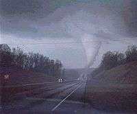
Touching down at around 6:25 AM EST in northwestern Hall County, this powerful pre-dawn F3 tornado traveled into southern White County, leaving a 13-mile long damage path through rural areas outside of Gainesville, Georgia, before dissipating at around 6:40 EST. It heavily damaged Lanier Elementary School and unroofed North Hall High School, while damaging or destroying several businesses. The school system did not fully recover until the next fall. At North Hall, the gymnasium was used as a temporary classroom until the end of the school year, while students at Lanier were temporarily relocated in three other area schools that were not affected by the tornado.[4] About 40 homes were completely destroyed and another 130 were damaged to varying degrees. 45 mobile homes were also damaged or destroyed, with 11 of the fatalities who were inside those structures. The other fatality occurred when a tractor-trailer was carried by the funnel and slammed into a school bus, killing the driver. Eight chicken houses were also destroyed and about 100,000 chickens were killed. 40 cattle were also killed by the storm.[4][5] In addition to the 12 fatalities, over 150 people were injured. A police officer was also killed after being hit by a car while assisting a motorist who was involved in an accident during the storm. The fatality was not directly attributed to the tornado itself.[4] Since recordkeeping began, this storm stands as the second deadliest Georgia tornado since 1950 and the deadliest since an F4 killed 18 on April 30, 1953 south of Macon.[6] The damage figures were estimated at between $15 million and $20 million with the majority of the damage in Hall County.[7]
The immediate Gainesville area is no stranger to deadly tornadoes. It was the site of the fifth deadliest tornado in United States history on April 6, 1936 during the Tupelo-Gainesville tornado outbreak, where two tornadoes merged into a very large F4 killing 203 including 70 at the Coopers Plant Factory. The tornado occurred only 12 hours after an F5 struck Tupelo, Mississippi, killing at least 216 (with others being unaccounted for), making it the fourth deadliest tornado on record including storms before 1950. Another tornado hit Gainesville in 1903 killing at least 100.[4]
The 1998 season, an El Niño year, had several deadly tornado outbreaks in addition to the Gainesville tornado including the Kissimmee Tornado Outbreak in Florida on February 23, the Birmingham, Alabama tornado on April 8, the Mississippi and Tennessee Valley outbreak on April 16 and the Spencer, South Dakota/Eastern tornado outbreak and derecho on May 30–31.
Stoneville tornado
A second significant tornado struck Stoneville, North Carolina, killing two people and injuring 27. This tornado destroyed or damaged 85% of the town. Leaving strong F3 damage in its wake, the Stoneville tornado left a 12 mile long damage path through parts of Rockingham County, beginning around 3:25 PM EST, producing a total of $34 million in damage.
A total of 500 to 600 residences were affected, along with numerous businesses; while several vehicles (including a fire truck) were also tossed some distance. The tornado initially touched down to the southwest of Stoneville in the town of Mayodan, where several buildings sustained major structural damage (including Mayodan United Methodist Church), and a textile factory was unroofed. $25 million of the damage tally was a result of the destruction of a large building in Mayodan. Canceled checks from Stoneville were found over 50 miles away in Huddleston, Virginia, while other debris was found scattered in and around the Martinsville area.[5][7]
As this tornado dissipated 6 miles northwest of the town of Eden, the parent supercell almost immediately produced an additional long-track F1 tornado, which continued a northeastward track through two southern Virginia counties, passing just northwest of the city of Danville.
See also
References
- ↑ http://www.ncdc.noaa.gov/stormevents/listevents.jsp?eventType=%28C%29+Tornado&beginDate_mm=03&beginDate_dd=20&beginDate_yyyy=1998&endDate_mm=03&endDate_dd=21&endDate_yyyy=1998&hailfilter=0.00&tornfilter=0&windfilter=000&sort=DT&submitbutton=Search&statefips=-999%2CALL
- ↑ March 20, 1998 Severe Weather Outbreak
- ↑ Base reflectivity radar imagery from KFCX WSR-88D from 1837Z March 20, 1998 through 2032Z March 20, 1998
- 1 2 3 4 Pre-dawn Killer: The 1998 Tornado Remembered | AccessNorthGa
- 1 2 1998 Tornadoes Archived October 8, 2008, at the Wayback Machine.
- ↑ Tornado Database, Tornado Maps, Tornado Paths
- 1 2 NCDC: Event Details